
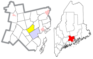
Waldo County is a county in the state of Maine, in the United States. As of the 2010 census, the population was 38,786. Its county seat is Belfast. The county was founded on 7 February 1827 from a portion of Hancock County and named after Brigadier-General Samuel Waldo, proprietor of the Waldo Patent.
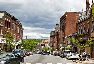
Belfast is a city in Waldo County, Maine, in the United States. As of the 2010 census, the city population was 6,668. Located at the mouth of the Passagassawakeag River estuary on Belfast Bay and Penobscot Bay. Belfast is the county seat of Waldo County. The seaport has a wealth of antique architecture in several historic districts, and remains popular with tourists.

Frankfort is a town on the Penobscot River estuary in Waldo County, Maine, United States. The population was 1,124 at the 2010 census.
Prospect is a town in Waldo County, Maine, United States. The population was 709 at the 2010 census.

Swanville is a town in Waldo County, Maine, United States. The population was 1,388 at the 2010 census.
Waldo is a town in Waldo County, Maine, United States. The population was 762 at the 2010 census. It is the home town of Heather Hemmens, who is known for her role on Hellcats.

The Penobscot River is a 109-mile-long (175 km) river in the U.S. state of Maine. Including the river's West Branch and South Branch increases the Penobscot's length to 264 miles (425 km), making it the second-longest river system in Maine and the longest entirely in the state. Its drainage basin contains 8,610 square miles (22,300 km2).

The Kentucky River is a tributary of the Ohio River, 260 miles (418 km) long, in the U.S. Commonwealth of Kentucky. The river and its tributaries drain much of the central region of the state, with its upper course passing through the coal-mining regions of the Cumberland Mountains, and its lower course passing through the Bluegrass region in the north central part of the state. Its watershed encompasses about 7,000 square miles (18,000 km2). It supplies drinking water to about one-sixth of the population of the Commonwealth of Kentucky.

Penobscot Bay is an inlet of the Gulf of Maine and Atlantic Ocean in south central Maine. The bay originates from the mouth of Maine's Penobscot River, downriver from Belfast. Penobscot Bay has many working waterfronts including Rockland, Rockport, and Stonington, and Belfast upriver. Penobscot Bay is between Muscongus Bay and Blue Hill Bay, just west of Acadia National Park.

Umbagog Lake is a wilderness lake located in Coös County, New Hampshire, and Oxford County, Maine. It is one of the most pristine lakes in the state of New Hampshire. It lies in the towns of Errol, New Hampshire, and Upton, Maine, as well as the townships of Cambridge, New Hampshire, and Magalloway Plantation, Maine. The name Umbagog is properly pronounced with the stress on the second syllable (um-BAY-gog) and is said to come from the Abenaki word for "shallow water". Both "Lake Umbagog" and "Umbagog Lake" are commonly used and accepted when referring to the body of water.

Goose Pond is a 625-acre (2.5 km2) water body located in Grafton County in western New Hampshire, United States, in the towns of Canaan and Hanover. It is considered a great pond by the state of New Hampshire. The lake has 6.3 miles (10.1 km) of shoreline, and is approximately 3 miles (5 km) long by 0.5 miles (0.8 km) wide. All but the northernmost end of the pond is in the town of Canaan. The average depth of the pond is approximately 10 feet (3.0 m), with the deepest part approximately 35 feet (11 m). The lake is part of the Mascoma River watershed, flowing to the Connecticut River.
This article shows U.S. Census totals for Waldo County, Maine, broken down by municipality, from 1900 to 2000.

Chesuncook Lake is a reservoir in the North Maine Woods and Piscataquis County, Maine. It is formed by the damming of the West Branch Penobscot River, by dams built in 1835, 1903, and 1916. It is approximately 22 miles (35 km) long and 1–4 miles wide, with a surface area of 25,183 acres (101.91 km2) and a maximum depth of 150 feet (46 m). It is the third-largest body of fresh water in Maine.
The Goose River is a river in Waldo County, Maine. From the outflow of Swan Lake in Swanville, the river runs 9.3 miles (15.0 km) south to the city of Belfast and its mouth at Belfast Bay, an arm of Penobscot Bay.

The Paugussett Trail is a 9.2-mile (14.8 km) Blue-Blazed hiking trail "system" in the lower Housatonic River valley in Fairfield County and, today, is entirely in Shelton and Monroe, Connecticut. Much of the trail is in Indian Well State Park and the Town of Monroe's Webb Mountain Park. The mainline trail is primarily southeast to northwest with three short side or spur trails.

The Zoar Trail is a 6.5-mile (10.5 km) Blue-Blazed hiking trail "system" in the lower Housatonic River valley in Fairfield County and is entirely in the Sandy Hook section of Newtown in the lower block of Paugussett State Forest.
The Kettletown Trails are a 4.6-mile (7.4 km) Blue-Blazed hiking trail "system" in the lower Housatonic River valley in Fairfield County and are in the towns of Southbury and Oxford -- primarily in the Kettletown State Park and the Jackson Cove recreation area belonging to the town of Oxford.

Swan Lake State Park is a public recreation area at the north end of 3-mile-long (4.8 km) Swan Lake in the town of Swanville, Waldo County, Maine. The state park's 67 acres (27 ha) offer opportunities for swimming, picnicking, canoeing, and fishing. The 1,370-acre (550 ha) lake supports populations of smallmouth bass, landlocked salmon, white perch, brook trout, and wild togue. The park is managed by the Maine Department of Agriculture, Conservation and Forestry.

Searsport is an incorporated town and deep water seaport located at the confluence of the Penobscot River estuary and the Penobscot Bay immediately SE of Sears Island and Cape Jellison in Waldo County, Maine, United States. The population was 2,615 at the 2010 census. Searsport includes the village of North Searsport. The town is known as "the home of the famous sea captains" and the "Antique Capital of Maine".
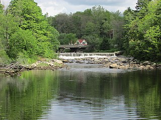
The Frankfort Dam impounds Marsh Stream near the center of Frankfort, Maine. Built in 1905 out of granite probably quarried at the nearby Mount Waldo Granite Works to provide power to local mills, it served for many years as a key element of the local economy. Its spillway has been adapted for use by a hydroelectric power station. The dam was listed on the National Register of Historic Places in 2003.


