
Perth is the capital and largest city of Western Australia and the fourth most populous city in Australia and Oceania, with a population of 2.2 million living in Greater Perth. Perth is part of the South West Land Division of Western Australia, with most of the metropolitan area on the Swan Coastal Plain between the Indian Ocean and the Darling Scarp. The city has expanded outward from the original British settlements on the Swan River, upon which the city's central business district and port of Fremantle are situated. Perth is located on the traditional lands of the Whadjuk Noongar people, where Aboriginal Australians have lived for at least 45,000 years.

Western Australia is a state of Australia occupying the western 33 percent of the land area of Australia, excluding external territories. It is bounded by the Indian Ocean to the north and west, the Southern Ocean to the south, the Northern Territory to the north-east, and South Australia to the south-east. Western Australia is Australia's largest state, with a total land area of 2,527,013 square kilometres (975,685 sq mi). It is the second-largest country subdivision in the world, surpassed only by Russia's Sakha Republic. As of 2021, the state has 2.76 million inhabitants—11 percent of the national total. The vast majority live in the south-west corner; 79 percent of the population lives in the Perth area, leaving the remainder of the state sparsely populated.

Albany is a port city in the Great Southern region in the Australian state of Western Australia, 418 kilometres (260 mi) southeast of Perth, the state capital. The city centre is at the northern edge of Princess Royal Harbour, which is a part of King George Sound. The central business district is bounded by Mount Clarence to the east and Mount Melville to the west. The city is in the local government area of the City of Albany. While it is the oldest colonial, although not European, settlement in Western Australia - predating Perth and Fremantle by over two years - it was a semi-exclave of New South Wales for over four years until it was made part of the Swan River Colony.

Hamersley is a residential suburb 14 kilometres north-northwest of the central business district of Perth, the capital of Western Australia, and six kilometres (4 mi) from the Indian Ocean. The suburb adjoins two major arterial roads—Mitchell Freeway to the west and Reid Highway to the south—and is within the City of Stirling local government area. It was built during the late 1960s and 1970s as part of the Government of Western Australia's response to rapidly increasing land prices across the metropolitan area.

The Town of Cambridge is a local government area in the inner western suburbs of the Western Australian capital city of Perth, about 5 kilometres (3 mi) west of Perth's central business district and extending to the Indian Ocean at City Beach. The Town covers an area of 22.0 square kilometres (8.5 sq mi) and had a population of almost 27,000 as at the 2016 Census. It was originally part of the City of Perth before the restructuring by the Western Australian State Government in 1994.

The City of Swan is a local government area of Western Australia. It is in the eastern metropolitan region of Perth and includes the Swan Valley and 42 suburbs. It is centred approximately 20 km north-east of the Perth central business district. The City covers an area of 1,042 km² and had an estimated population of 155,653 in 2020.
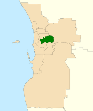
The Division of Swan is an Australian electoral division located in Western Australia.

Esperance is a town in the Goldfields–Esperance region of Western Australia, on the Southern Ocean coastline approximately 720 kilometres (450 mi) east-southeast of the state capital, Perth. The urban population of Esperance was 12,145 at June 2018. Its major industries are tourism, agriculture, and fishing.

Bellevue is an eastern suburb of Perth, Western Australia in the local government areas of the City of Swan and the Shire of Mundaring. It is at the foot of the slopes of Greenmount, a landmark on the Darling Scarp that is noted in the earliest of travel journals of the early Swan River Colony.

The Division of Pearce is an Australian electoral division in the state of Western Australia. It was created at the 1989 redistribution and named after George Pearce, the longest serving member of the Australian Senate, serving from 1901 to 1938. For most of its existence, Pearce was a hybrid urban-rural seat that covered Perth's outer northern suburbs before fanning inland from the Indian Ocean to take in portions of the Wheatbelt southeast, east and northeast of the capital. However, as of the 2021 redistribution, Pearce is largely coterminous with the City of Wanneroo in Perth's northern suburbs. It has had four members: Fred Chaney, Judi Moylan, Christian Porter, and Tracey Roberts. The first three were members of the Liberal Party, whereas Roberts, a former mayor of Wanneroo, is a member of the Labor Party.

Ellenbrook is a northeastern suburb of Perth, Western Australia, about 30 km (19 mi) from Perth's central business district (CBD), located within the City of Swan. Ellenbrook, and its neighbouring suburbs of The Vines and Aveley, are unusual for Perth in being a significant distance from neighbouring suburbs. Given this relative isolation and the distance from the CBD, Ellenbrook has been designed and developed as a self-sustainable community. Since the upgrade of Gnangara Road and the completion of the Tonkin Highway Northlink, access to Ellenbrook has improved. The Morley–Ellenbrook railway line is well underway as at June 2021 and this will enable better public transport. At the time of the 2016 census there were 22,681 people living in the gazetted suburb, by June 2018, it was estimated that the urban population for Ellenbrook and surrounds had grown to 41,382. It is envisioned that Ellenbrook will eventually become a satellite city, with a population of 80,000.

Swan Hills is an electoral district of the Legislative Assembly in the Australian state of Western Australia.

The Anglican Schools Commission (ASC) was established in 1985, following the passage of a resolution by the Perth Diocesan Synod of the Anglican Church of Australia.
Aveley is a suburb of Perth, Western Australia, east of Ellenbrook and south of The Vines. In 1897 George Hardey Barrett Lennard, grandson of Edward Pomeroy Barrett-Lennard, purchased a property in the area of which is now Aveley, naming it "Belhus" after his family's estate in Belhus, Essex, England. The name "Aveley", deriving from the eponymous town where the estate was located, was approved as a suburb name on 6 September 2006, before which the area was part of Ellenbrook. It is bordered by Gnangara Road and Lake Yakine to the south, a small part of West Swan Road, the Ellen Brook and Chateau Place to the east, The Broadway, Doig Road, and Cashman Avenue to the north, and Henley Brook Avenue to the west. The suburb is accessible from Henley Brook Avenue, The Promenade, Gnangara Road, and West Swan Road.
Brabham is a suburb located about 21 km (13 mi) north-east of Perth's central business district. The suburb is located in the City of Swan just south of Henley Brook, formerly being a part of that suburb before it was gazetted in May 2011. The suburb was named after Australian motor racing personality Sir Jack Brabham who competed in the 1962 Australian Grand Prix, held at the nearby Caversham Airfield. The suburb is part of the City of Swan's urban growth corridor and is bordered by Park Street to the north, Murray Street to the east, Harrow Street to the south and Drumpellier Drive and Isoondon Street to the west. It is located in the Whiteman Ward of the City of Swan.
East Perth Locomotive Depot was a major steam locomotive depot for the Western Australian Government Railways from a year before the end of the First World War in 1917 until the end of the steam railway era on its railway system in 1970/1971. The previous locomotive depot had been located west of the Perth railway station.

Gilmore College is an independent public co-educational high day school, located in Orelia, an outer south-western suburb of Perth in Western Australia, Sited approximately 32 kilometres (20 mi) from the Perth CBD, the school is located on Dargin Place. Formerly known as Kwinana Senior High School, and originally was called Medina Junior High School, the name Gilmore College was adopted in 2006.

Claise Brook is a stream which empties into Claisebrook Cove before running into the Swan River in Perth, Western Australia. The area surrounding the stream is on the outskirts of the Perth CBD and is part of the suburb of East Perth. Claise Brook was once an important water course from which the numerous interconnected fresh water lakes north of Perth emptied into during the wet season before entering the Swan River.
Charles Street is a major road in the inner northern suburbs of Perth, Western Australia. It runs from Newcastle Street and extends up to London Street, providing a connection between Mitchell Freeway and Wanneroo Road. It is the southern section of part of State Route 60, which continues north along Wanneroo Road.

