
Northamptonshire is a ceremonial county in the East Midlands of England. It is bordered by Leicestershire, Rutland and Lincolnshire to the north, Cambridgeshire to the east, Bedfordshire, Buckinghamshire, Oxfordshire to the south and Warwickshire to the west. Northampton is the largest settlement and the county town.
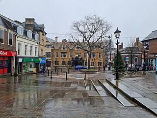
Wellingborough is a market town and civil parish in the North Northamptonshire unitary authority area of Northamptonshire, England. It is 65 miles (105 km) from London and 11 miles (18 km) from Northampton, and is on the north side of the River Nene.

Raunds is a market town in North Northamptonshire, England. It had a population of 9,379 at the 2021 census.

Rushden is a town and civil parish in North Northamptonshire, England, around 18 miles (29 km) east of Northampton. The parish is on the border with Bedfordshire, 12 miles (19 km) north of Bedford.
The Borough of Wellingborough was a non-metropolitan district and borough in Northamptonshire, England, from 1974 to 2021. It was named after Wellingborough, its main town, but also included surrounding rural areas.

The River Ise is a river in Northamptonshire, England and a tributary of the River Nene.

Wilby is a suburban linear village and civil parish in the Wellingborough built-up area of North Northamptonshire, England. The suburb is 3 miles south-west of Wellingborough town centre.

Wellingborough and Rushden is a constituency in Northamptonshire represented in the House of Commons of the UK Parliament. The seat is currently held by Labour MP Gen Kitchen, after the recall of MP Peter Bone in December 2023 which resulted in a by-election in February 2024.

Finedon is a town and civil parish in North Northamptonshire, England, with a population at the 2021 census of 4,552. In 1086 when the Domesday Book was completed, Finedon was a large royal manor, previously held by Queen Edith, wife of Edward the Confessor.
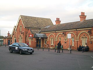
Wellingborough railway station is a Grade II listed station located in the market town of Wellingborough in Northamptonshire, England. It lies on the Midland Main Line and is 65 miles (104 km) from London St. Pancras. The station is operated by East Midlands Railway, which is also the primary operator serving the station with passenger services under the Luton Airport Express brand.
The Borough Council of Wellingborough in Northamptonshire, UK was elected every four years. After the last boundary changes in 1999, thirty-six councillors were elected from 16 wards. The council was abolished in 2021, with the area becoming part of North Northamptonshire.

The Northamptonshire Fire and Rescue Service (NFRS) is a fire and rescue service covering the county of Northamptonshire, United Kingdom. NFRS covers an area of 948 square miles (2,460 km2) area with a population of around 750,000.

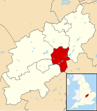
North Northamptonshire is one of two local government districts in Northamptonshire, England. Its council is a unitary authority, being a district council which also performs the functions of a county council. It was created in 2021. The council is based in Corby, the district's largest town. Other notable towns are Kettering, Wellingborough, Rushden, Raunds, Desborough, Rothwell, Irthlingborough, Thrapston and Oundle.

The Northamptonshire Football Association, also simply known as the Northamptonshire FA, is the governing body of football in the English county of Northamptonshire.
The Wellingborough School Ground is a cricket ground which was used by Northamptonshire County Cricket Club in 43 First-class matches for 45 years between 1946 and 1991, and 17 List A games between 1970 and 1991. It is now used predominantly for Women's County Twenty20 Cricket. The Thatched Pavilion which adjoins the ground features, as the last step an incoming batsman takes on the way to the wicket, a paving stone from W. G. Grace's home in Bristol. Murray Witham, a geography teacher at the school, rescued the stone from Grace's home when it was being demolished in the 1930s and brought it to the school.

The ceremonial county of Northamptonshire is divided into two unitary authorities West Northamptonshire and North Northamptonshire. Up until 31 March 2021, Northamptonshire was divided into seven districts. The former districts of Northamptonshire were South Northamptonshire, Northampton, Daventry, Wellingborough, Kettering, Corby, and East Northamptonshire.

Finedon Top Lodge Quarry, also known as Finedon Gullet is a 0.9-hectare (2.2-acre) geological Site of Special Scientific Interest east of Wellingborough in Northamptonshire. It is a Geological Conservation Review site revealing a sequence of middle Jurassic limestones, sandstones and ironstones, and is the type section for a sequence of sedimentary rocks known as the 'Wellingborough Member'. It was created by quarrying for the underlying ironstone for use at Wellingborough and Corby Steelworks; the ore was transported by the 1,000 mm gauge Wellingborough Tramway.

Hemmingwell is a medium sized, densely populated council estate in Wellingborough, Northamptonshire, England. The area had a population of 8,272 at the 2011 census. The estate is often known as 'Wellingborough's toughest estate'.

The 1999 Borough Council of Wellingborough election took place on 6 May 1999 to elect members of Borough Council of Wellingborough in Northamptonshire, UK. This was on the same day as other local elections.

