
A village development committee in Nepal was the lower administrative part of its Ministry of Federal Affairs and Local Development. Each district had several VDCs, similar to municipalities but with greater public-government interaction and administration. There were 3,157 village development committees in Nepal. Each village development committee was further divided into several wards depending on the population of the district, the average being nine wards.
Belbhar is a town in Banke District in the Bheri Zone of south-western Nepal. At the time of the 1991 Nepal census it had a population of 3,583 and had 697 houses in the town.
Ganapur is a town in Banke District in the Bheri Zone of south-western Nepal. At the time of the 1991 Nepal census it had a population of 3,775 and had 735 houses in the town best area for industries.
Narainapur is a town in Banke District in the Bheri Zone of south-western Nepal. At the time of the 1991 Nepal census it had a population of 3,870 and had 692 houses in the town.
Naubasta is a town in Banke District in the Bheri Zone of south-western Nepal. At the time of the 1991 Nepal census it had a population of 11,160 and had 1663 houses in the town.
Bhorle is a Village Development Committee in Rasuwa District in the Bagmati Zone of northern Nepal. At the time of the 1991 Nepal census, it had a population of 4884 people residing in 903 individual households.

Briddim is a village development committee in Rasuwa District in the Bagmati Zone of northern Nepal. At the time of the 1991 Nepal census it had a population of 722 people living in 165 individual households.
Chilime is a village development committee in Rasuwa District in the Bagmati Zone of northern Nepal. At the time of the 1991 Nepal census it had a population of 1281 people living in 261 individual households.
Dandagaun is a village development committee in Rasuwa District in the Bagmati Zone of northern Nepal. At the time of the 1991 Nepal census it had a population of 1782 people living in 320 individual households.
Dhaibung is a village development committee in Rasuwa District in the Bagmati Zone of northern Nepal. At the time of the 1991 Nepal census it had a population of 3880 people living in 724 individual households.
Gatlang is a village development committee in Rasuwa District in the Bagmati Zone of northern Nepal. At the time of the 1991 Nepal census it had a population of 1533 people living in 328 individual households.

Goljung is a village development committee in Rasuwa District in the Bagmati Zone of northern Nepal. At the time of the 1991 Nepal census it had a population of 836 people living in 172 individual households.

Haku is a village development committee in Rasuwa District in the Bagmati Zone of northern Nepal. At the time of the 1991 Nepal census it had a population of 2055 people living in 378 individual households.
Jibjibe is a village development committee (VDC) in Rasuwa District in the Bagmati Zone of northern Nepal. At the time of the 1991 Nepal census it had a population of 4944.
Laharepauwa is a village development committee in Rasuwa District in the Bagmati Zone of northern Nepal. At the time of the 1991 Nepal census it had a population of 4276 people living in 774 individual households.
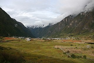
Langtang was a village development committee (VDC) in Rasuwa District in the Bagmati Zone of northern Nepal. It was located within the Langtang valley, approximately 40 miles northeast of Kathmandu. At the time of the 1991 Nepal census, it had a population of 468 people living in 100 individual households.

Ramche is a village development committee in Rasuwa District in the Bagmati Zone of northern Nepal.
Saramthali, Rasuwa is a village development committee in Rasuwa District in the Bagmati Zone of northern Nepal. At the time of the 1991 Nepal census it had a population of 3359 people living in 624 individual households.
Thulogaun is a village development committee in Rasuwa District in the Bagmati Zone of northern Nepal. At the time of the 1991 Nepal census it had a population of 1247 people, living in 249 individual households.

Thuman is a village development committee in Rasuwa District in the Bagmati Zone of northern Nepal. At the time of the 1991 Nepal census it had a population of 929 people living in 188 individual households.


