
A tsunami is a series of waves in a water body caused by the displacement of a large volume of water, generally in an ocean or a large lake. Earthquakes, volcanic eruptions and other underwater explosions above or below water all have the potential to generate a tsunami. Unlike normal ocean waves, which are generated by wind, or tides, which are in turn generated by the gravitational pull of the Moon and the Sun, a tsunami is generated by the displacement of water from a large event.
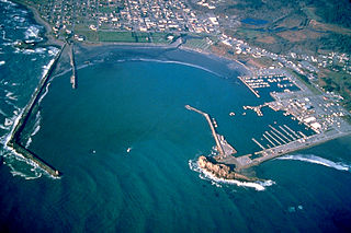
Crescent City is the only incorporated city in Del Norte County, California; it is also the county seat. Named for the crescent-shaped stretch of sandy beach south of the city, Crescent City had a total population of 6,673 in the 2020 census, down from 7,643 in the 2010 census.

The Hawaiian Islands are an archipelago of eight major volcanic islands, several atolls, and numerous smaller islets in the North Pacific Ocean, extending some 1,500 miles from the island of Hawaiʻi in the south to northernmost Kure Atoll. Formerly called the Sandwich Islands by Europeans, the present name for the archipelago is derived from the name of its largest island, Hawaiʻi.

The 1964 Alaskan earthquake, also known as the Great Alaskan earthquake and Good Friday earthquake, occurred at 5:36 PM AKST on Good Friday, March 27. Across south-central Alaska, ground fissures, collapsing structures, and tsunamis resulting from the earthquake caused about 131 deaths.
The Intergovernmental Oceanographic Commission of UNESCO (IOC/UNESCO) was established by resolution 2.31 adopted by the General Conference of the United Nations Educational, Scientific and Cultural Organization (UNESCO). It first met in Paris at UNESCO Headquarters from 19 to 27 October 1961. Initially, 40 States became members of the commission. The IOC assists governments to address their individual and collective ocean and coastal management needs, through the sharing of knowledge, information and technology as well as through the co-ordination of programs and building capacity in ocean and coastal research, observations and services.
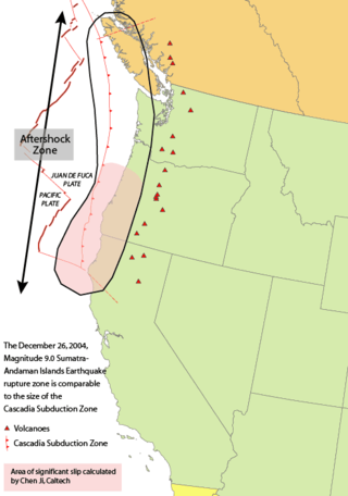
The 1700 Cascadia earthquake occurred along the Cascadia subduction zone on January 26, 1700, with an estimated moment magnitude of 8.7–9.2. The megathrust earthquake involved the Juan de Fuca Plate from mid-Vancouver Island, south along the Pacific Northwest coast as far as northern California. The plate slipped an average of 20 meters (66 ft) along a fault rupture about 1,000 kilometers long.

A tsunami warning system (TWS) is used to detect tsunamis in advance and issue the warnings to prevent loss of life and damage to property. It is made up of two equally important components: a network of sensors to detect tsunamis and a communications infrastructure to issue timely alarms to permit evacuation of the coastal areas. There are two distinct types of tsunami warning systems: international and regional. When operating, seismic alerts are used to instigate the watches and warnings; then, data from observed sea level height are used to verify the existence of a tsunami. Other systems have been proposed to augment the warning procedures; for example, it has been suggested that the duration and frequency content of t-wave energy is indicative of an earthquake's tsunami potential.

The Pacific Tsunami Warning Center (PTWC), located on Ford Island, Hawaii, is one of two tsunami warning centers in the United States, covering Hawaii, Guam, American Samoa and the Northern Mariana Islands in the Pacific, as well as Puerto Rico, the U.S. Virgin Islands and the British Virgin Islands in the Caribbean Sea. Other parts of the United States are covered by the National Tsunami Warning Center.

Deep-ocean Assessment and Reporting of Tsunamis (DART) is a component of an enhanced tsunami warning system.
The Indian Ocean Tsunami Warning System was set up to provide warning to inhabitants of nations bordering the Indian Ocean of approaching tsunamis. The tsunami warning system has been in use since the mid-2000s.

Bruce Bolt was an Australian-born American seismologist and a professor of earth and planetary science at the University of California, Berkeley. Professor Bolt was known as a pioneer of seismic engineering. He served for 15 years on the California Seismic Safety Commission leading public debate on earthquake safety in that state, and acted as a consultant on major projects throughout the world. As well, Bolt published a number of popular and technical books on seismology.
Patrick Mendis is an educator, diplomat, author, and executive in government service in the United States. A former American diplomat and military professor during the Clinton, Bush, and Obama administrations, he held various positions in the U.S. Departments of Agriculture, Defense, Energy, and State. He was appointed twice as a commissioner of the U.S. National Commission for UNESCO at the State Department by the Obama administration. His appointment to the UNESCO Commission ended during the Trump administration when the White House withdrew from the UN agency.
Patrick Kenji Takahashi is an American biochemical engineer and popular science writer. He has published more than a hundred scientific papers and written four books. He is director emeritus of the Hawaii Natural Energy Institute at the University of Hawaii.

A continent is any of several large geographical regions. Continents are generally identified by convention rather than any strict criteria. A continent could be a single landmass or a part of a very large landmass, as in the case of Asia or Europe. Due to this, the number of continents varies; up to seven or as few as four geographical regions are commonly regarded as continents. Most English-speaking countries recognize seven regions as continents. In order from largest to smallest in area, these seven regions are Asia, Africa, North America, South America, Antarctica, Europe, and Australia. Different variations with fewer continents merge some of these regions; examples of this are merging North America and South America into America, Asia and Europe into Eurasia, and Africa, Asia, and Europe into Afro-Eurasia.
Although National Oceanic and Atmospheric Administration (NOAA) scientists at the Pacific Tsunami Warning Center (PTWC) in Hawaii eventually issued warnings of a possible tsunami from the large earthquake off Sumatra, the waves outran notification systems at jet speeds of 500 mph (804 km/h), catching hundreds of thousands of people unaware. The following is a timeline of the 2004 Indian Ocean earthquake. All times are Coordinated Universal Time (UTC), on Sunday, 26 December 2004.

The National Tsunami Warning Center (NTWC) is one of two tsunami warning centers in the United States, covering all coastal regions of the United States and Canada, except Hawaii, Guam, the Northern Mariana Islands, Puerto Rico and the U.S. Virgin Islands. Until 2013, it was known as the West Coast and Alaska Tsunami Warning Center.
Frank Edwin Snodgrass was a physical oceanographer and electrical engineer. He spent nearly all of his career working with Prof. Walter Munk at Scripps Institution of Oceanography (SIO). The Cecil H. and Ida M. Green branch of the University of California Systemwide Institute of Geophysics and Planetary Physics (IGPP), in La Jolla, California has been strongly linked to Scripps since the 1960s through joint faculty appointments, research interests, and shared facilities. Other IGPP branches can be found at the Los Angeles, Irvine, Santa Cruz and Riverside campuses. Snodgrass spent many years researching and measuring the ocean tides and waves. During his career he had opportunities to work with fellow scientists around the world, including collaborations through the IGPP campuses, with Woods Hole Oceanographic Institution in Massachusetts and with the National Institute of Oceanography in England.
Kären Esther Wigen is an American historian, geographer, author and educator. She is the Frances and Charles Field Professor of history at Stanford University.

Harsh Kumar Gupta is an Indian earth scientist and seismologist, known for his pioneering work on estimation of reservoir-induced earthquakes. He is a former vice chancellor of the Cochin University of Science and Technology (CUSAT) and a Raja Ramanna Fellow at the National Geophysical Research Institute (NGRI), Hyderabad. A recipient of the 1983 Shanti Swarup Bhatnagar Prize for Science and Technology, the highest Indian award in the science and technology category, and the 2008 Waldo E. Smith Award, Gupta was awarded the fourth highest Indian civilian honour of the Padma Shri in 2006.
Martin W. Lewis is an American historical geographer, author, and academic. He is a senior lecturer emeritus in History at Stanford University.