
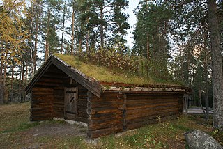
Sylling is a village in Lier municipality, in the county of Buskerud, Norway. Sylling is located 27 kilometres west of Oslo. The settlement has 707 inhabitants as of 1 January 2016. [1] [2]
Sylling is a village in Lier municipality, in the county of Buskerud, Norway. Sylling is located 27 kilometres west of Oslo. The settlement has 707 inhabitants as of 1 January 2016. [1] [2]
Sylling is located on Holsfjorden, the southeastern arm of Tyrifjorden. Sylling is known for agriculture, particularly the cultivation of fruit. Local farms have a long history of cultivation of strawberries and vegetables. The good soil is due to gravel after the Last glacial period including Sylling-moraine. Its population is about 1700. [3]
Pilgrims' Way (Pilegrimsleden) must have passed Sylling and stopped at the local Olav's spring (Olavskilden). The pilgrims arrived on foot or they could travel by boat across Holsfjorden. During the Civil war era in Norway, King Sverre and the Birchleg forces overcame the Bagler forces of Magnus V at the Battle of Hørte Bridge (Slaget ved Hørte bro) during the Summer of 1178. The victory was the first of many for Sverre. Subsequently, during autumn, the Birchlegs went north to Trøndelag and won control of Nidaros.

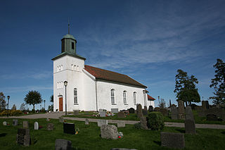
Sylling Church (Sylling kirke) is a church constructed in a rectangular shape. There has been a church on the same site since the Middle Ages. The church has a cemetery and next to it is the old rectory. The structure is of stone and brick and the church has 370 seats. Sylling church was built in 1852. In 2001, there were major renovation. At that time some old gravestones with inscriptions and some other items were found which were of interest to the National Cultural Heritage (Riksantikvaren). The church was re-opened for normal use again in December 2001. [4] [5]

Bærum is a municipality in the Greater Oslo Region in Akershus County, Norway. It forms an affluent suburb of Oslo on the west coast of the city. Bærum is Norway's fifth largest municipality with a population of 128,760 (2021). The administrative centre of the municipality is the town of Sandvika. Bærum was established as a municipality on 1 January 1838.

Vennesla is a municipality in Agder county, Norway. It is located in the traditional district of Sørlandet. The administrative centre of the municipality is the village of Vennesla. Other villages in Vennesla include Grovane, Hægeland, Homstean, Mushom, Øvre Eikeland, Øvrebø, Røyknes, and Skarpengland. Vennesla lies about 17 kilometres (11 mi) north of the city of Kristiansand in the Otra river valley.
Våler is a municipality in Innlandet county, Norway. It is located in the traditional district of Solør. The administrative centre of the municipality is the village of Våler. Other villages in Våler include Braskereidfoss, Gravberget, and Risberget.

Dovre is a municipality in Innlandet county, Norway. It is located in the traditional district of Gudbrandsdal. The administrative centre of the municipality is the village of Dovre. Other villages in Dovre include Dombås and Hjerkinn. The municipality is bordered on the north by Oppdal municipality, on the east by Folldal, on the south by Sel and Vågå, and on the northwest by Lesja. The highest peak in the municipality is Snøhetta at a height of 2,286 metres (7,500 ft).

Krødsherad is a municipality in Buskerud county, Norway. The administrative centre of the municipality is the village of Noresund. The municipality of Krødsherad was established when it was separated from the municipality of Sigdal on 1 January 1901.

Bamble is a municipality in Telemark county, Norway. It is located in the traditional district of Grenland. The administrative centre of the municipality is the town of Langesund. Other population centres in Bamble include the town of Stathelle and the villages of Bamble, Botten, Herre, and Valle.

Sogndal is a municipality in Vestland county, Norway. It is located on the northern shore of the Sognefjorden in the traditional district of Sogn. The village of Hermansverk is the administrative center of Sogndal municipality. Other villages include Kaupanger, Kjørnes, Fimreite, Nornes, and Fjærland. Sogndal Airport, Haukåsen is located 10 kilometres (6.2 mi) southwest of Kaupanger.
Hokksund is a town in the municipality of Øvre Eiker in the county of Viken, Norway.
Botne is a former municipality in Vestfold county, Norway.

Høvåg is a former municipality in the old Aust-Agder county in Norway. The 77 km2 (30 sq mi) municipality existed from 1865 until its dissolution in 1962. It was located in the southern part of the present-day municipality of Lillesand which is now in Agder county. The administrative centre of the municipality was the village of Høvåg where the Høvåg Church is located. Old coastal settlements in Høvåg include Ulvøysund, Gamle Hellesund, Skottevik, Kjøbmannsvig and Åkerøyhamn. The village of Høvåg is located midway between the towns of Lillesand and Kristiansand.

Sjåstad is a village in Lier municipality, Buskerud county, Norway. Sjåstad and the neighboring village of Oddevall are regarded as one community. The two villages have a combined population of 556 (2014).

Ytre Sandsvær is a former municipality in Buskerud county, Norway.

Onsøy is a peninsula and a former municipality in Østfold county, Norway. The administrative centre was Gressvik.

Glemmen is a parish and former municipality with the city of Fredrikstad, Østfold county, Norway.

Idd is a parish and former municipality in Halden, Østfold county, Norway.

Varteig is a village in Sarpsborg and a former municipality in Østfold County, Norway.
Skjeberg is a district of Sarpsborg, Østfold County, Norway. Skjeberg was formerly a municipality in Østfold County. The last administrative centre was at Borgenhaugen. As of 2018, Skjeberg has a population of 1,397.

Borge is a parish and former municipality in Østfold county, Norway. Today it is located in the northeast part of Fredrikstad municipality, near the border with Sarpsborg.

Norderhov is a former municipality located within Ringerike in Buskerud county, Norway.

Tranby is a village in Lier municipality in Buskerud, Norway.
59°54′N10°17′E / 59.900°N 10.283°E
| | This Buskerud location article is a stub. You can help Wikipedia by expanding it. |