Kristiansand Region is a statistical metropolitan region in the counties of Vest-Agder and Aust-Agder in southern Norway. It is centered on the city of Kristiansand. The region consist of 6 municipalities in the centre of Southern Norway. Vennesla, Songdalen, and Birkenes are inland municipalities while Kristiansand, Søgne, and Lillesand are coastal municipalities. Kristiansand is the largest municipality in population in the region and Birkeland is the largest in area.

Birkeland is the administrative centre of the municipality of Birkenes in Aust-Agder county, Norway. The village is located on the eastern shore of the river Tovdalselva, across the river from the village of Flakk. The Norwegian National Road 41 runs through the village. The village is located about 30 kilometres (19 mi) northeast of the city of Kristiansand and about 14 kilometres (8.7 mi) northwest of Lillesand.

Uldalsåna is a lake on the border of the municipalities of Birkenes and Froland in Aust-Agder county, Norway. It is part of the Tovdalselva river drainage basin. On the southeastern end of the lake, there is a hydroelectric dam which releases water into the waterfall, Hanefoss, on its way down to the lake Herefossfjorden near the village of Herefoss. The lake is fed by the rivers Rettåna and Skjeggedalsåna. The lake Nystølfjorden flows into the river Skjeggedalsåna.
Ogge is a lake in the municipalities of Birkenes and Iveland in Aust-Agder county, Norway. It is located about 40 kilometres (25 mi) north of the city of Kristiansand, just east of the villages of Vatnestrøm and Oggevatn. The 6.71-square-kilometre (2.59 sq mi) lake includes about 360 islands and reefs. The overall length of the lake is approximately 16 kilometres (9.9 mi). The Sørlandsbanen railway line and the Norwegian County Road 405 both run along the west side of the lake.
Herefossfjorden is a lake in the municipality of Birkenes in Aust-Agder county, Norway. The 3.7-square-kilometre (1.4 sq mi) lake is about 9 kilometres (5.6 mi) long and it is part of the Tovdalselva river. The Gauslåfjorden and Uldalsåna lakes flow into Herefossfjorden near the village of Herefoss at the northern end of the lake. The Uldalsåna lake is held back by a dam and the Gauslåfjorden flows over a waterfall into the Herefossfjorden. The Norwegian National Road 41 runs along the eastern shore. The village of Herefoss lies on the northern edge of the lake and the village of Søre Herefoss lies at the southern end of the fjord. The old municipality of Herefoss existed from 1838 until 1967 and it included all the land surrounding the lake.
Vegusdal is a former municipality in Aust-Agder county, Norway. The 325-square-kilometre (125 sq mi) municipality existed from 1877 until its dissolution in 1967. It was located in the northwestern part of the present-day municipality of Birkenes. The administrative centre of the municipality was the village of Engesland where Vegusdal Church is located. The Norwegian County Road 405 runs through Vegusdal south to the village of Mosby in Vennesla.

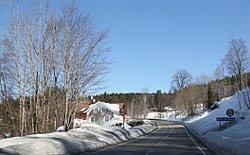
Herefoss is a village in Birkenes municipality in Aust-Agder county, Norway. The village is located on the northeastern end of the Herefossfjorden which is a large lake on the river Tovdalselva. The Norwegian National Road 41 runs through the village connecting it to Søre Herefoss, about 8 kilometres (5.0 mi) to the south, and to Hynnekleiv in Froland, about 10 kilometres (6.2 mi) to the north. The lake Uldalsåna lies about 2 kilometres (1.2 mi) to the northwest.

Norwegian County Road 404 is a Norwegian county road in Aust-Agder county, Norway. The 27.83-kilometre (17.29 mi) long road runs between the village of Frivoll in Grimstad municipality in the southeast and the village of Søre Herefoss in Birkenes municipality at the south end of the Herefossfjorden. The road connects to the Norwegian National Road 41 at Søre Herefoss and it connects to the European route E18 highway at Frivoll. The road passes between the two lakes Syndle and Rore in rural Grimstad, just northeast of the village of Roresand. Prior to a 2010 government reform, the road was classified as a Norwegian national road.
Mjåvatn is a village in Froland municipality in Aust-Agder county, Norway. The village is located along Norwegian County Road 42, about 10 kilometres (6.2 mi) northwest of the village of Blakstad-Osedalen, about 4 kilometres (2.5 mi) south of the village of Hinnebu, and about 10 kilometres (6.2 mi) east of the village of Herefoss.
Oggevatn is a village in Birkenes municipality in Aust-Agder county, Norway. The village is located on the western shore of the large lake Ogge, just north of the municipal border with Iveland. The Sørlandsbanen railway line runs through the village. The village of Vatnestrøm lies about 5 kilometres (3.1 mi) southwest of Oggevatn.
Rugsland is a village in Birkenes municipality in Aust-Agder county, Norway. The village is located on the western shore of the river Tovdalselva, about 5 kilometres (3.1 mi) south of the village of Mollestad. The village of Svaland lies about 5 kilometres (3.1 mi) to the northwest.

Sennumstad or Senumstad is a village in Birkenes municipality in Aust-Agder county, Norway. The village is located on the western shore of the river Tovdalselva at the junction of the Norwegian National Road 41 and the Norwegian County Road 406. The Senumstad Bridge crosses the river in the village. The nearby village of Væting lies about 5 kilometres (3.1 mi) to the northwest, the village of Søre Herefoss lies about 5 kilometres (3.1 mi) to the north, and the municipal centre of Birkeland lies about 10 kilometres (6.2 mi) to the south.
Vatnestrøm is a village in Iveland municipality in Aust-Agder county, Norway. The village is located along the Norwegian County Road 405, on the western shore of the lake Ogge. The municipal centre of Birketveit lies about 12 kilometres (7.5 mi) to the northwest and the village of Oggevatn in the neighboring municipality of Birkenes lies about 6 kilometres (3.7 mi) to the northeast.
Væting is a village in Birkenes municipality in Aust-Agder county, Norway. The village is located just off the Norwegian County Road 406, about 5 kilometres (3.1 mi) northwest of the village of Senumstad.
Ås is a village in Birkenes municipality in Aust-Agder county, Norway. The village is located about 2 kilometres (1.2 mi) southeast of the village of Engesland, along the Norwegian County Road 405.

Norwegian National Road 41 is a Norwegian national road that runs through Telemark, Aust-Agder, and Vest-Agder counties in Norway. The road runs between the village of Brunkeberg in Kviteseid municipality in Telemark county in the north and Timenes in Hånes in the city of Kristiansand in Vest-Agder county in the south. The 172.9-kilometre (107.4 mi) long road connects to the European route E134 highway in the north and to the European route E18 highway in the south. The road runs for 12.5 kilometres (7.8 mi) in Vest-Agder county, 89 kilometres (55 mi) in Aust-Agder county, and 71.4 kilometres (44.4 mi) in Telemark county. The southern half of the road runs along the river Tovdalselva and the lake Herefossfjorden, and it is located in a fault zone called the Kristiansand-Porsgrunn grabenen.

Herefoss Church is a parish church in Birkenes municipality in Aust-Agder county, Norway. It is located in the village of Herefoss, at the northern end of the Herefossfjorden, just west of the Norwegian National Road 41. The church is part of the Herefoss parish in the Vest-Nedenes deanery in the Diocese of Agder og Telemark. The white, wooden church was built in an octagonal style in 1865 by the architect Jacob Wilhelm Nordan. The church seats about 200 people. It was consecrated on 11 October 1865 by the Bishop Jacob von der Lippe. This is the third church at Herefoss, but the other two were located a little closer to the lake. That site was prone to flooding, so the present church was moved further from the shoreline.

Herefoss is a former municipality in Aust-Agder county, Norway. The municipality existed from 1838 until its dissolution in 1967 when it was merged into Birkenes municipality. Herefoss was a 148-square-kilometre (57 sq mi) area surrounding the Herefossfjorden. The administrative centre was the village of Herefoss where the Herefoss Church is located. The other main village was Søre Herefoss, located in the southern part of the municipality.