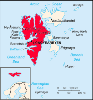
Hinlopen Strait is the strait between Spitsbergen and Nordaustlandet in Svalbard, Norway. It is 150 kilometers (93 mi) long and 10 to 60 kilometers wide. The strait is difficult to pass because of pack ice. It is believed to have been named after Thijmen Jacobsz Hinlopen.

Haakon VII Land is a land area at the northwestern part of Spitsbergen, Svalbard, between Woodfjorden and Kongsfjorden.
Andrée Land is the land area between Wijdefjorden and Woodfjorden on Spitsbergen, Svalbard in Arctic Norway. Limited in the south by a line from Woodfjorden through Vonbreen to Holtedahlfonna eastwards to the upper part of Abrahamsenbreen through Ruskbreen, Millarpasset, Lisbetbreen and Vestfjorddalen to Vestfjorden.
Moseøya Bird Sanctuary is a bird reserve at Svalbard, Norway, established in 1973. It includes Moseøya, south of Danes Island, part of Albert I Land. The protected area covers a total area of around 1,400,000 square metres.
Bockfjorden is a fjord in Haakon VII Land at Spitsbergen, Svalbard, at the western side of Woodfjorden. Bockfjorden is named after Arctic explorer Franz-Karl von Bock. At the western side of the fjord is the inactive volcano Sverrefjellet.
Vegafonna is an ice cap in Gustav Adolf Land on Nordaustlandet in the Svalbard archipelago. It is located on the peninsula Scaniahalvøya, between the bay Palanderbukta to the north and Torellneset to the south. The glacier is named after the vessel SS Vega. Further west on the peninsula is the ice cap Glitnefonna.
Scaniahalvøya is a peninsula in Gustav Adolf Land on Nordaustlandet, Svalbard. It is located south of Wahlenbergfjorden and the bay Palanderbukta, and northeast of Hinlopen Strait. The peninsula is named after the Swedish province of Scania. Large parts of Scaniahlavøya are glaciated, with the two icecaps Vegafonna and Glitnefonna.
Mosselhalvøya is a peninsula in Ny-Friesland at Spitsbergen, Svalbard. It is located between Mosselbukta and Sorgfjorden. At the northern part of the peninsular is the coastal plain of Verlegenhukflya, with its northernmost point Verlegenhuken.
Nordvestøyane is an archipelago in Albert I Land at Spitsbergen, Svalbard. Among the islands in the group are Fuglesongen (4.1 km²) and Klovningen (2.2 km²).
Woodfjorddalen is a valley in Andrée Land at Spitsbergen, Svalbard. It forms a southeastward continuation of the fjord Woodfjorden. The upper part of the valley is covered by the glacier Abrahamsenbreen. At the lower part of the valley is the flat sand and clay area Poninskiøyra and the hill Tantalushaugen. A side valley to the south is Piræusdalen, six kilometers from the head of Woodfjorden. North of the valley is the mountain group Vaktarfjella, with a length of about eleven kilometers.
Vaktarfjella is a mountain group in Andrée Land at Spitsbergen, Svalbard. It has an extension of about eleven kilometers, and is located north of the valley Woodfjorddalen. The highest summit in the group is Vaktaren, with a height of 1,227 m.a.s.l. The northwestern mountain in the group is Kapp Ringertz.
Oxfordhalvøya is a peninsula in Wahlenbergfjorden at the southwestern side of Nordaustlandet, Svalbard. It is located between Bodleybukta and Etonbreen at the head of the fjord. The bay Kløverbladbukta cuts into the peninsula, and its highest point is Carfaxhaugen at 103 m.a.s.l.
Idunneset, also called Indunneset Point, is a headland in Gustav V Land at Nordaustlandet, Svalbard. It is located at the northern side of Wahlenbergfjorden, east of the glacier Bragebreen.
Rosenthalbreen is a glacier in Gustav Adolf Land in Nordaustlandet, Svalbard. It is named after German shipowner and expedition organizer Friedrich Wilhelm Albert Rosenthal. The glacier is an outlet from Vegafonna. It borders to the coastal plain of Svartknausflya, and drains into the sea east of Torellneset, into the bay Ulvebukta of Hinlopen Strait.
Perthesøya is an island at the coast of Gustav V Land at Nordaustlandet, Svalbard. It is located outside Torellneset, in the southern part of Augustabukta. The island is named after a German publishing company.
Norddomen is an ice dome of Austfonna at Nordaustlandet, Svalbard. The glacier cap of Austfonna has two significant ice domes, Norddomen and Sørdomen further south. Norddomen is the highest point of Nordaustlandet, with a height of about 700 m.a.s.l.
Sørdomen is an ice dome of Austfonna at Nordaustlandet, Svalbard. The glacier cap of Austfonna has two significant ice domes, Sørdomen and Norddomen further north. The part of Austfonna west of Sørdomen is called Palanderisen.
Palanderisen is a glaciated area in Gustav Adolf Land at Nordaustlandet, Svalbard. It has an extension of about 35 kilometers and is part of the ice cap of Austfonna, located west of the Sørdomen ice dome, between Etonbreen and Ericadalen. The area is named after Arctic explorer Louis Palander. It includes Sørfonna.
Smeerenburgfjorden is a fjord in Albert I Land at Spitsbergen, Svalbard. It has a length of about twenty kilometers and a width of about four kilometers. The fjord is named after the old whaling settlement Smeerenburg, which was situated at the southern part of Amsterdam Island. The fjord is located between the peninsulas of Vasahalvøya and Reuschhalvøya, and connects westwards through the straits of Danskegattet and Sørgattet. The Smeerenburgbreen glacier debouches into the head of the fjord.