Moyen-Mono is a prefecture located in the Plateaux Region of Togo. The prefecture seat is located in Tohoun.
Elizewo is a village in the administrative district of Gmina Kcynia, within Nakło County, Kuyavian-Pomeranian Voivodeship, in north-central Poland.
Pieńki Kościelskie is a village in the administrative district of Gmina Osięciny, within Radziejów County, Kuyavian-Pomeranian Voivodeship, in north-central Poland.
Micielno is a village in the administrative district of Gmina Chodecz, within Włocławek County, Kuyavian-Pomeranian Voivodeship, in north-central Poland.

Qaragöz is a village in the Zangilan Rayon of Azerbaijan.

Kluski is a village in the administrative district of Gmina Pątnów, within Wieluń County, Łódź Voivodeship, in central Poland. It lies approximately 10 kilometres (6 mi) south of Pątnów, 18 km (11 mi) south of Wieluń, and 97 km (60 mi) south-west of the regional capital Łódź.
Godzisz is a village in the administrative district of Gmina Sobolew, within Garwolin County, Masovian Voivodeship, in east-central Poland. It lies approximately 4 kilometres (2 mi) south of Sobolew, 22 km (14 mi) south of Garwolin, and 73 km (45 mi) south-east of Warsaw.
Nowy Sielc is a village in the administrative district of Gmina Krasnosielc, within Maków County, Masovian Voivodeship, in east-central Poland.
Kalinowiec is a village in the administrative district of Gmina Płoniawy-Bramura, within Maków County, Masovian Voivodeship, in east-central Poland. It lies approximately 10 kilometres (6 mi) north-west of Maków Mazowiecki and 81 km (50 mi) north of Warsaw.
Kowalewice Włościańskie is a village in the administrative district of Gmina Świercze, within Pułtusk County, Masovian Voivodeship, in east-central Poland.
Dojutrów is a village in the administrative district of Gmina Blizanów, within Kalisz County, Greater Poland Voivodeship, in west-central Poland.
Teklin is a village in the administrative district of Gmina Trzcinica, within Kępno County, Greater Poland Voivodeship, in west-central Poland.
Wodziczna is a village in the administrative district of Gmina Trzcinica, within Kępno County, Greater Poland Voivodeship, in west-central Poland. It lies approximately 16 kilometres (10 mi) south of Kępno and 159 km (99 mi) south-east of the regional capital Poznań.
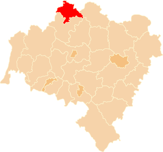
Ligota Wołczyńska is a village in the administrative district of Gmina Wołczyn, within Kluczbork County, Opole Voivodeship, in south-western Poland.
Miodne is a settlement in the administrative district of Gmina Nowogard, within Goleniów County, West Pomeranian Voivodeship, in north-western Poland.
Barnisławice is a village in the administrative district of Gmina Golczewo, within Kamień County, West Pomeranian Voivodeship, in north-western Poland. It lies approximately 5 kilometres (3 mi) south-east of Golczewo, 25 km (16 mi) south-east of Kamień Pomorski, and 52 km (32 mi) north-east of the regional capital Szczecin.
Changshun County is a county of Guizhou, China. It is under the administration of the Qiannan Buyei and Miao Autonomous Prefecture.
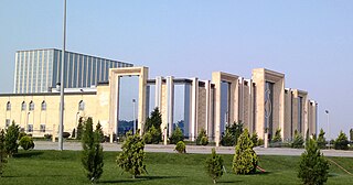
The Buta Palace is one of the principal performing arts centers and music venues of Baku. It consists of two event halls and adjacent parking lot for 800 cars. The greater hall is a caravanserai-stylized venue, capable of accommodating about 2,000 visitors. The minor hall is designed for conferences and presentations and can house 400 visitors. The size of the greater hall is 1,572 square metres (16,920 sq ft) and the minor hall — 652 square metres (7,020 sq ft).
Rouached is a town and commune in Mila Province, Algeria. At the 1998 census it had a population of 25399.

Gare de Tergnier is a railway station serving the town Tergnier, Aisne department, northern France. It is situated on the Creil–Jeumont railway.