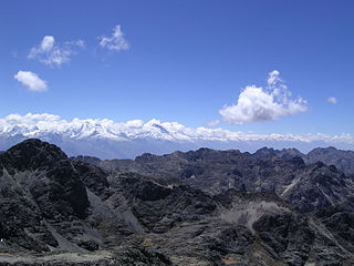
The Recuay Province is one of twenty provinces of the Ancash Region in Peru. Its seat is the town of Recuay.

The Pomabamba Province is one of twenty provinces of the Ancash Region in Peru. It was formerly called Pumapampa and today it is also known as "The City of Cedars". It is located at the left bank of the Pomabamba river, at 3,063 meters (10,049 ft) above sea level. It was created by law on February 21, 1861.

Pucaraju is a mountain in the Cordillera Blanca in the Andes of Peru, about 5,346 metres (17,539 ft) high or 5,322 metres (17,461 ft) high depending on the source. It is situated in the Ancash Region, Recuay Province, Ticapampa District. Pucaraju lies west of Yanamarey and northeast of Lake Querococha.

Cuncush is a mountain in the southern part of the Cordillera Blanca in the Andes of Peru, about 5,000 metres (16,404 ft) high. It is situated in the Ancash Region, Recuay Province, Catac District. Cuncush lies southwest of Mururaju and northwest of Pukarahu.

Yana Kunkush is a mountain in the southern part of the Cordillera Negra in the Andes of Peru, about 4,600 metres (15,092 ft) high. It is situated in the Ancash Region, Aija Province, Aija District, and in the Recuay Province, Catac District. Yana Kunkush lies southeast of Sach'a Hirka and east of a lake of that name.

Wishka Hirka or Wishpa Hirka is a 4,934-metre-high (16,188 ft) mountain in the southern part of the Cordillera Blanca in the Andes of Peru. It is located in the Ancash Region, Recuay Province, Catac District. Wishka Hirka lies southwest of Qiwllarahu.

Ichic Jeulla is a 5,091-metre-high (16,703 ft) mountain in the southern part of the Cordillera Blanca in the Andes of Peru. It is located in the Ancash Region, Recuay Province, Catac District. Ichic Jeulla lies southeast of Caullaraju.

Qiwlla Hirka is a mountain in the southern part of the Cordillera Blanca in the Andes of Peru, about 5,000 m (16,000 ft) high. It is located in the Ancash Region, Recuay Province, Catac District. Qiwlla Hirka lies northeast of Qiwllarahu and Challwa, near Pastu Ruri.

Kuntur Sinqa is a mountain in the Cordillera Blanca in the Andes of Peru, about 4,630 m (15,190 ft) high. It is situated in the Ancash Region, Recuay Province, Catac District. Kuntur Sinqa lies west of Mururahu at a lake named Qishqiqucha.

Rocotopunta is a mountain in the Cordillera Blanca in the Andes of Peru, about 4,400 m (14,436 ft) high. It is located in the Ancash Region, Recuay Province, Ticapampa District, northeast of Lake Querococha. Rocotopunta lies between Yanamarey Creek to the north and Conde Creek to the south.

Minapata is a mountain in the southern part of the Cordillera Blanca in the Andes of Peru, about 5,400 m (17,700 ft) high. It is located in the Ancash Region, Bolognesi Province, Aquia District, and in the Recuay Province, Catac District. Minapata lies south of Challwa and northeast of Qiwllarahu.

Puka Hirka is a mountain in the Cordillera Negra in the Andes of Peru, about 4,600 m (15,100 ft) high. It is situated in the Ancash Region, Aija Province, on the border of the districts of Aija and La Merced, in the Huaraz Province, Huaraz District, and in the Recuay Province, Recuay District.
Puka Hirka or Pukahirka may refer to:

Wank'ap'iti is a 4,976-metre-high (16,325 ft) mountain in the Cordillera Negra in the Andes of Peru. It is situated in the Ancash Region, Aija Province, Aija District, and in the Recuay Province, Ticapampa District. Wank'ap'iti lies southeast of Puka Allpa.
Kuntur Wayi or Kuntur Wayin may refer to:

Qullpa Hirka is a mountain in the Cordillera Negra in the Andes of Peru which reaches a height of approximately 4,400 m (14,400 ft). It lies in the Ancash Region, Recuay Province, in the northern part of the Cotaparaco District.

Izcopata is a mountain in the Cordillera Negra in the Andes of Peru which reaches a height of approximately 4,400 m (14,400 ft). It is located in the Ancash Region, Recuay Province, Cotaparaco District. Izcopata is also the name of a place southeast of the mountain.


