
Lampung, officially the Province of Lampung, is a province of Indonesia. It is located on the southern tip of the island of Sumatra. It has a short border with the province of Bengkulu to the northwest, and a longer border with the province of South Sumatra to the north, as well as a maritime border with the provinces of Banten and Jakarta to the east. It is the home of the Lampung people, who speak their own language and possess their own written script. Its capital city is Bandar Lampung.

The Java Sea is an extensive shallow sea on the Sunda Shelf, between the Indonesian islands of Borneo to the north, Java to the south, Sumatra to the west, and Sulawesi to the east. Karimata Strait to its northwest links it to the South China Sea. It is a part of the western Pacific Ocean.

Anambas Islands Regency is a small archipelago of Indonesia, located 150 nautical miles northeast of Batam Island in the North Natuna Sea between the Malaysian mainland to the west and the island of Borneo to the east. Geographically part of the Tudjuh Archipelago, it is administratively a regency within the Riau Islands Province. It covers a land area of 661.47 square kilometres (255.39 sq mi) and had a population of 37,411 at the 2010 Census and 47,402 at the 2020 Census; the official estimate as at mid 2023 was 50,140. The administrative centre is at Tarempa on Siantan Island.

The Gaspar Strait is a strait separating the Indonesian islands Belitung and Bangka. It connects the Java Sea with the South China Sea.
Tambelan archipelago is a group of 68 islands off the west coast of West Kalimantan (Borneo), Indonesia, just north of the equator. The archipelago is located on the north opening of Karimata Strait which separates Borneo and Belitung island. Geographically it is part of the Tudjuh Archipelago, and administratively forms a district (kecamatan) of Bintan Regency within the Riau Islands Province. It covers a land area of 90.4 km2 and had a population of 4,960 in mid 2022. Major islands include Big Tambelan, Mendarik, Uwi, Benua, and Pejantan. The islands are divided into eight administrative villages (kelurahan) - Batu Lepuk, Kampung Hilir, Kampung Melayu, Kukup, Pengikik, Pulau Mentebung, Pulau Pinang and Teluk Sekuni. As a historical side note; It was the first Dutch territory captured by the Japanese in World War 2.
South Natuna is an archipelago off the west coast of the island of Borneo, the southernmost group of the Natuna Islands in the South China Sea. Geographically it is part of the Tudjuh Archipelago, and administratively part of the Riau Islands Province of Indonesia.
Badas Islands is a group of islands in the Tudjuh Archipelago in the South China Sea between the Malaysian mainland to the west and the island of Borneo to the east. Administratively it is part of Bintan Regency within the Riau Islands province of Indonesia under island district/kecamatan of Tambelan.
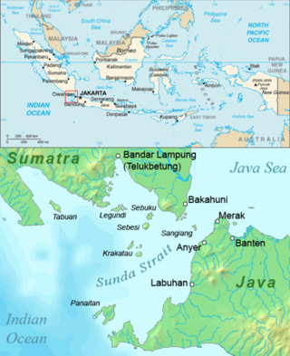
Pulau Legundi is an Indonesian island in the Sunda Strait between Java and Sumatra. It is one of the larger islands in the Strait and lies at the western end of Sumatra's Lampong Bay, in the province of Lampung.

South Lampung Regency is a regency of Lampung, Sumatra, Indonesia, a strip of land surrounding the provincial capital of Bandar Lampung on its northern and eastern sides. The regency is bounded to the west by the new Pesawaran Regency, to the northeast by the East Lampung Regency, and to the south by the Sunda Strait; as such it is a major transit corridor to/from Java island. It has an area of 2,109.74 km2, and a population of 909,989 at the 2010 census and 1,064,301 at the 2020 census; the official estimate as at mid 2023 was 1,101,376. The regency seat is the town of Kalianda.

Tanggamus Regency is a regency (kabupaten) of Lampung Province, Sumatra, Indonesia. It has an area of 4,654.96 km2 which consists of a land area of 2,855.46 km2 and a sea area of 1,799.5 km2. It had a population of 534,595 at the 2010 Census and 640,275 at the 2020 Census; the official estimate as at mid 2023 was 662,542. The regency seat is the town of Kota Agung Pusat. The regency was created on 21 March 1997 from what were previously the western districts of South Lampung Regency, but districts in its eastern part split away on 29 October 2008 to form the new Pringsewu Regency. It lies in the southwest of the province, and surrounds Semangka Bay on its west, north and east coasts.
Salahnama Island is a small island in the Strait of Malacca, off the coast of Sumatra, about 40 km from Tanjungbalai and 10 km south of Pandang Island. It belongs to Indonesia.
Pandang Island is a small island in the Strait of Malacca, off the coast of Sumatra, about 47 km from Tanjungbalai and 10 km north of Salahnama Island. It belongs to Indonesia.
Little Karimun is an island in the Strait of Malacca, about 58 kilometres (36 mi) west of Batam and 35 km south-west of Singapore. It belongs to the Karimun Regency of the Riau Islands Province of Indonesia. It is located just off the east coast of Sumatra.
Rondo Island is Indonesia's northernmost territory, located in the Andaman Sea, with a 0.650 km2 area 35m above sea level. The island is one of the outlying islands of Indonesia in the Aceh province of the Sumatra region. It is administratively part of Ujung Bau village in the Sukakarya District of Sabang City, whose administration center is on Weh Island, south of Rondo. Rondo is 50 km offshore from Indonesia's Sumatra mainland. This otherwise uninhabited island, accessible only by boat, has an Indonesian military outpost with a heliport and blue-roofed barracks, an adjacent lighthouse complex with a red-roofed lighthouse keeper's house and a white skeletal lighthouse topped with a viewing gallery and lantern.

Manipa Island is an island in West Seram Regency, Maluku Province, Indonesia. It is located 8 km off the western coast of Kelang at the western end of Seram Island and 25 km off the western coast of Buru. Including adjacent small islands, it forms an administrative district (kecamatan) within the regency, with its district centre at Masawoi. The district covers an area of 159.71 km2 and had a population of 7,165 at the 2020 Census; the official estimate as at mid 2023 was 7,793.
Sibungor Island is an islet on the Brunei River in Brunei-Muara District, Brunei. A proposal for an 8 hectares protection status to be implemented on the island. The island is home to proboscis monkeys and forest swamps.
Masoni Island, also known as Sonit Island, is an island in Central Sulawesi, Indonesia. The island is low-lying, and is around 12 miles northwest of Timpaus Island. The waters surrounding the island are rich in corals, and the island is considered a regional water conservation area.

The Kuala Belait Port, also known as Kuala Belait Wharf, is a port operated by both the Brunei Shell Petroleum (BSP) and Maritime and Port Authority Brunei Darussalam (MPABD). The port can only accommodate low-draught ships. It is one of the only three existing ports in the country.
