Niger is a landlocked nation in West Africa located along the border between the Sahara and Sub-Saharan regions. Its geographic coordinates are longitude 16°N and latitude 8°E. Its area is 1.267 million square kilometers, of which 1 266 700 km² is land and 300 km² water, making Niger slightly less than twice the size of France.

Protected areas or conservation areas are locations which receive protection because of their recognized natural, ecological or cultural values. There are several kinds of protected areas, which vary by level of protection depending on the enabling laws of each country or the regulations of the international organizations involved.
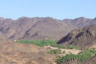
The Aïr Mountains or Aïr Massif is a triangular massif, located in northern Niger, within the Sahara Desert. Part of the West Saharan montane xeric woodlands ecoregion, they rise to more than 1,800 m (5,900 ft) and extend over 84,000 km2 (32,000 sq mi). Lying in the midst of desert north of the 17th parallel, the Aïr plateau, with an average altitude between 500 and 900 m, forms an island of Sahel climate which supports a wide variety of life, many pastoral and farming communities, and dramatic geological and archaeological sites. There are notable archaeological excavations in the region that illustrate the prehistoric past of this region. The endangered painted hunting dog once existed in this region, but may now be extirpated due to human population pressures in this region.
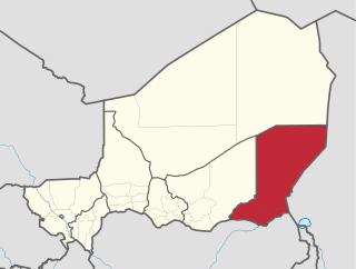
Diffa is an administrative region in the southeast of Niger. The capital of the region is the city of Diffa.

The Region of Maradi is one of seven Regions of Niger. It is located in south-center Niger, east of the Region of Tahoua, west of Zinder, and north of Nigeria's city of Kano. The administrative center is at Maradi. The population of the Region is majority Hausa.
The UN Environment World Conservation Monitoring Centre (UNEP-WCMC) is an executive agency of UN Environment, based in Cambridge in the United Kingdom. UNEP-WCMC has been part of UN Environment since 2000, and has responsibility for biodiversity assessment and support to policy development and implementation. The World Conservation Monitoring Centre was previously an independent organisation jointly managed by IUCN, UN Environment and WWF established in 1988, and prior to that the Centre was a part of the IUCN Secretariat.

The Scandola Nature Reserve is located on the west coast of the French island of Corsica, within the Corsica Regional Park. The reserve was established in 1975. The park and reserve has been recognized by the United Nations as a Natural World Heritage Site, and was inscribed on the World Heritage List in 1983.

The Dosso Partial Faunal Reserve is a nature reserve in the southwest Dosso Region of Niger. It is a Partial Faunal Reserve IUCN type IV, established 1 January 1962. The reserve covers 3,065 square kilometres in the mouth of Dallol Bosso valley, a seasonal wash and ancient riverbed running from the Azawagh region, near where it reaches the Niger River valley. It is situated near the W du Niger National Park.

The Tamou Total Reserve is a nature reserve in the southwest of Niger. It is a Total Faunal Reserve IUCN type IV, covering some 75,600 hectares within the Tillaberi Region. The reserve abuts W du Niger, and is primarily dedicated to the protection of African Elephant populations which migrate through the region.
The Gadabedji Total Reserve is a nature reserve in the central region of Niger. It is a Total Faunal Reserve IUCN type IV, covering some 76,000 hectares within the northern tip of the Maradi Region, just north of the town of Dakoro, and south of the border with the Agadez Region. The reserve is also recognized biosphere reserve by the Unesco since 2017.

The Aïr and Ténéré Addax Sanctuary is a nature reserve in the north center of the nation of Niger. The reserve forms part of the larger Aïr and Ténéré National Nature Reserve, which is a UNESCO World Heritage Site. The Aïr and Ténéré National Nature Reserve covers 77,360 square kilometres (29,870 sq mi), of which 12,800 square kilometres (4,900 sq mi) form the Aïr and Ténéré Addax Sanctuary.
The Gaoligong Mountains,, are a mountainous sub-range of the southern Hengduan Mountain Range, located in the western Yunnan highlands and straddling the border of southwestern China and northern Myanmar (Burma).

The Termit Massif is a mountainous region in southeastern Niger. Just to the south of the dunes of Tenere desert and the Erg of Bilma, the northern areas of the Termit, called the Gossololom consists of black volcanic peaks which jut from surrounding sand seas. The southern Termit is a roughly east–west range of heavily eroded black sandstone. Its foothills on the south west are the Koutous hills.

Kep National Park is a national park in Cambodia's Kep Province that was established in 1993 and covers an area of 66.64 km2 (25.73 sq mi) The nearest town lies at Krong Kaeb.
The Central African mangroves ecoregion consists of the largest area of mangrove swamp in Africa, located on the coasts of West Africa, mainly in Nigeria.

The World Database on Protected Areas (WDPA) is the largest assembly of data on the world's terrestrial and marine protected areas, containing more than 200,000 protected areas as of October 2017, with records covering 245 countries and territories throughout the world. The WDPA is a joint venture between the United Nations Environment Programme World Conservation Monitoring Centre and the International Union for Conservation of Nature World Commission on Protected Areas.