Niger is a landlocked nation in West Africa located along the border between the Sahara and Sub-Saharan regions. Its geographic coordinates are longitude 16°N and latitude 8°E. Its area is 1.267 million square kilometers, of which 1 266 700 km2 is land and 300 km2 water, making Niger slightly less than twice the size of France.
The W National Park or W Regional Park is a major national park in West Africa around a meander in the River Niger shaped like the letter W. The park includes areas of the three countries Niger, Benin and Burkina Faso, and is governed by the three governments. Until 2008, the implementation of a regional management was supported by the EU-funded project ECOPAS. The three national parks operate under the name W Transborder Park.. The section of W National Park lying in Benin, measuring over 8,000 km2 (3,100 sq mi), came under the full management of African Parks in June 2020. In Benin, W National Park is contiguous with Pendjari National Park which is also under the management of African Parks.
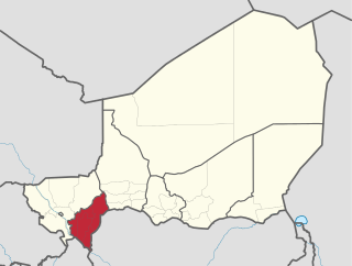
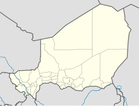
Dosso is one of the eight Regions of Niger. The region has an area of 31,002 square kilometres (11,970 sq mi), with a population of 2,078,339 as of 2011.

Burkina Faso is largely wild bush country with a mixture of grass and small trees in varying proportions. The savanna region is mainly grassland in the rainy season and semi desert during the harmattan period. Fauna, one of the most diverse in West Africa, includes the elephant, hippopotamus, buffalo, monkey, lions, crocodile, giraffe, various types of antelope, and a vast variety of bird and insect life. The country has 147 mammal species, 330 aquatic species including 121 species of fish and 2067 different plant species. Of the plant species, the dominant endemic species are shea tree (Butyrospermum parkii) and the baobab, the former plant species has immense economic value to the country.

The wildlife of Niger is composed of its flora and fauna. The wildlife protected areas in the country total about 8.5 million hectares, which is 6.6% of the land area of the country, a figure which is expected to eventually reach the 11% percent target fixed by the IUCN with addition of more areas under the reserve category. The dama gazelle has become a national symbol. Under the Hausa name meyna or ménas the dama appears on the badge of the Niger national football team, who are popularly called the Ménas.
The Dosso Kingdom is a precolonial state in what is now southwest Niger which has survived in a ceremonial role to the modern day.

The Termit Massif Total Reserve is a nature reserve in the southeast of Niger which was established in January 1962. In March 2012, a national nature and cultural reserve was established covering an area of 100,000 square kilometres (39,000 sq mi), including the entire area of the Termit Massif and Tin Toumma desert, making it the largest single protected area in Africa. The area provides habitat for many critically endangered species. Prominent among them is the addax antelope, which is categorized under the IUCN Red List as one of the rarest and most endangered species in the world; about 300 of them are reported in the reserve. A conservation effort has been launched by the Government of Niger in collaboration with many international conservation agencies. The reserve has also been declared an UNESCO World Heritage Site for the biodiversity value of the Termit Massif and surrounding Sahara Desert and for the cultural value of its archaeological sites.

The Tamou Total Reserve is a nature reserve in the southwest of Niger. It is a Total Faunal Reserve IUCN type IV, covering some 75,600 hectares within the Tillaberi Region. The reserve abuts W du Niger, and is primarily dedicated to the protection of African Elephant populations which migrate through the region.
The Tadrès Total Reserve (T'adéras/Tadress) is a nature reserve in the central north of Niger, southwest the city of Agadez. It is a Total Faunal Reserve IUCN type IV, covering some 788,928 hectares within the Agadez Region. The reserve follows the northeast - southwest flow of the Tadrès valley, a Kori or seasonal wash and ancient river bed south of the Aïr Mountains. It was originally dedicated to the protection of Oryx populations which have largely disappeared from the region. In the 1940s, the valley was an important migration route for the animals from the Tenere desert to the Adar in the south of the country. It remains a transhumance route for domesticated cattle and camels, as well as wild Dorcas and Ménas Gazelles

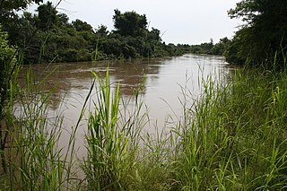
The Dallol Bosso is one of two major seasonal river valleys in southwest Niger. The Dallol Bosso valley runs from the Azawagh area in the Sahara west and south through the Dosso Region where it reaches the Niger River valley.
The Gadabedji Total Reserve is a nature reserve in the central region of Niger. It is a Total Faunal Reserve IUCN type IV, covering some 76,000 hectares within the northern tip of the Maradi Region, just north of the town of Dakoro, and south of the border with the Agadez Region. The reserve is also recognized biosphere reserve by the Unesco since 2017.

The Aïr and Ténéré Addax Sanctuary is a nature reserve in the north center of the nation of Niger. The reserve forms part of the larger Aïr and Ténéré National Nature Reserve, which is a UNESCO World Heritage Site. The Aïr and Ténéré National Nature Reserve covers 77,360 square kilometres (29,870 sq mi), of which 12,800 square kilometres (4,900 sq mi) form the Aïr and Ténéré Addax Sanctuary.

The West African giraffe, Niger giraffe or Nigerien giraffe, is a subspecies of the giraffe distinguished by its light colored spots, which is found in the Sahel regions of West Africa.

There are at least seven nature reserves in Jordan. In 1966, the organization that would later start Jordan's nature reserves, the Royal Society for the Conservation of Nature, was founded. RSCN's first efforts involved bringing back severely endangered species. In 1973, RSCN, was given the right to issue hunting licenses, giving RSCN an upper hand in preventing extinction. The first step was the founding of Jordan's first nature reserve, Shaumari Wildlife Reserve, in 1975. The primary purpose was to create means to breed endangered species, specifically: the Arabian oryx, gazelles, ostriches and Persian onagers in their natural environment.

Harikanassou is a large village and rural commune in the Boboye Department of the Dosso Region of southwest Niger, 90.7 kilometres (56.4 mi) by road southeast of the capital of Niamey. At the time of the 2012 census, the rural community had 23,567 residents living in 3,340 households. Onion cultivation is a chief source of income for many, along with the cultivation of lettuce, beans, squashes, and tomatoes.
The Kidepo Game Reserve is a protected area located in Budi County, Eastern Equatoria State, South Sudan, Africa. With an area of 1200 km2, this reserve is located 4° 04'N and 33° 28'E on the South Sudan/Uganda border, where it forms a contiguous ecosystem with Uganda's Kidepo Valley National Park.

The Association to Safeguard Giraffes in Niger is an organization formed to help the giraffes of Niger, including ensuring the preservation of their habitat in the face of devastating agricultural expansion.
Kouré is a rural community located 60 kilometres (37 mi) east of Niamey, the capital of Niger. The town lies on both sides of the road from Niamey to Dallol Bosso.

The Benin–Niger border is 277 km in length and runs from the tripoint with Burkina Faso in the west to the tripoint with Nigeria in the east.