Tagant Plateau

Last updated
Tagant Plateau
الهضبة تكانت
Natural region
Passe de djouk.jpg
Landscape of the Tagant region in Djouk
Mauritania rel95.jpg
Location of the Tagant plateau in Mauritania
Country Mauritania
Elevation
400 m (1,300 ft)

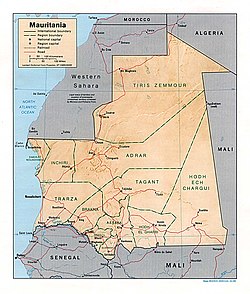
The Tagant Plateau is located in eastern Mauritania, forming a stony part of the Sahara Desert. The Tagant Region, a national administrative division, is named after the plateau.

Contents

Geography

Some towns are located at the foot of the Tagant Plateau's slopes, which form cliffs in some places. Among these areas are Tichit, Moudjéria and Rachid. Tidjikdja lies on the Tagant itself. The Assaba Massif, where Late Ordovician glacial formations have been identified, is a southward prolongation of the Tagant Plateau. [1] The Aoukar, the dry basin of a former lake lies beyond the southern escarpments of the Tagant Plateau. [2]

History

Beginning in mid-17th century, migrants from the Adrar Plateau region moved in and displaced the native population of the Tagant Plateau, the Toucouleur people, who now inhabit Futa Toro along the Senegal river. [3] :17,50

The Tartega Gueltas oasis is one of the few wetlands in the region where there were still desert crocodiles in 1976, [4] but the population seems to have been last seen in 1996. [5]

See also

Related Research Articles

<span class="mw-page-title-main">Sahara desert (ecoregion)</span> The ecology of the Sahara desert

The Sahara desert, as defined by the World Wide Fund for Nature (WWF), includes the hyper-arid center of the Sahara, between latitudes 18° N and 30° N. It is one of several desert and xeric shrubland ecoregions that cover the northern portion of the African continent.

<span class="mw-page-title-main">Geography of Algeria</span> Geographical features of Algeria

Algeria comprises 2,381,740 square kilometres (919,590 sq mi) of land, more than 80% of which is desert, in North Africa, between Morocco and Tunisia. It is the largest country in Africa. Its Arabic name, Al Jazair, is believed to derive from the rocky islands along the coastline of the Mediterranean Sea. The northern portion, an area of mountains, valleys, and plateaus between the Mediterranean and the Sahara Desert, forms an integral part of the section of North Africa known as the Maghreb. This area includes Morocco, Tunisia, and the northwestern portion of Libya known historically as Tripolitania.

<span class="mw-page-title-main">Geography of Mauritania</span>

Mauritania, a country in the Western Region of the continent of Africa, is generally flat, its 1,030,700 square kilometres forming vast, arid plains broken by occasional ridges and clifflike outcroppings. Mauritania is the world’s largest country lying entirely below an altitude of 1,000 metres (3,300 ft). It borders the North Atlantic Ocean, between Senegal and Western Sahara, Mali and Algeria. It is considered part of both the Sahel and the Maghreb. A series of scarps face southwest, longitudinally bisecting these plains in the center of the country. The scarps also separate a series of sandstone plateaus, the highest of which is the Adrar Plateau, reaching an elevation of 500 metres or 1,640 feet. Spring-fed oases lie at the foot of some of the scarps. Isolated peaks, often rich in minerals, rise above the plateaus; the smaller peaks are called Guelbs and the larger ones Kedias. The concentric Guelb er Richat is a prominent feature of the north-central region. Kediet ej Jill, near the city of Zouîrât, has an elevation of 915 metres or 3,002 feet and is the highest peak.

<span class="mw-page-title-main">Libyan Desert</span> North-eastern part of the Sahara Desert

The Libyan Desert is a geographical region filling the northeastern Sahara Desert, from eastern Libya to the Western Desert of Egypt and far northwestern Sudan. On medieval maps, its use predates today's Sahara, and parts of the Libyan Desert include the Sahara's most arid and least populated regions; this is chiefly what sets the Libyan Desert apart from the greater Sahara. The consequent absence of grazing, and near absence of waterholes or wells needed to sustain camel caravans, prevented Trans-Saharan trade between Kharga close to the Nile, and Murzuk in the Libyan Fezzan. This obscurity saw the region overlooked by early European explorers, and it was not until the early 20th century and the advent of the motor car before the Libyan Desert started to be fully explored.

<span class="mw-page-title-main">Sahara</span> Desert on the African continent

The Sahara is a desert spanning North Africa. With an area of 9,200,000 square kilometres (3,600,000 sq mi), it is the largest hot desert in the world and the third-largest desert overall, smaller only than the deserts of Antarctica and the northern Arctic.

<span class="mw-page-title-main">Hoggar Mountains</span> Mountain range in Algeria

The Hoggar Mountains are a highland region in the central Sahara in southern Algeria, along the Tropic of Cancer. The mountains cover an area of approximately 550,000 km².

<span class="mw-page-title-main">Tagant Region</span> Region of Mauritania

Tagant is a region in south-central Mauritania named for the Tagant Plateau. Its capital is Tidjikdja. Other major cities/towns include Tichit and Rachid, Nbeika. The region borders the Mauritanian regions of Adrar to the north, Hodh Ech Chargui to the east, Hodh El Gharbi and Assaba to the south and Brakna to the west. The Aoukar basin, which formerly gave name to the greater region, is located in the southern part of Tagant.

Tichit, or Tichitt, is a partly abandoned village at the foot of the Tagant Plateau in central southern Mauritania that is known for its vernacular architecture. The main agriculture in Tichit is date farming, and the village is also home to a small museum.

<span class="mw-page-title-main">Tidjikja</span> Commune and town in Tagant, Mauritania

Tidjikja is the capital of the Tagant region of central Mauritania, lying on the Tagant plateau. Founded in 1680, it has a population of around 11,000 people.

<span class="mw-page-title-main">Adrar Plateau</span> Natural region in Mauritania

<span class="mw-page-title-main">Aoukar</span> Natural region in Mauritania

Aoukar or Erg Aoukar is a geological depression area of south eastern Mauritania. It is located between Kiffa and Néma, south of the Tagant Plateau.

<span class="mw-page-title-main">Kiffa</span> Commune and town in Assaba Region, Mauritania

Kiffa is a large town in the far south region of Mauritania, and the name of an administrative area within the local Assaba Region. Kiffa is located at 16.63°N 11.4°W, some 600 kilometres (370 mi) from the coast and at the western end of the Aoukar sand sea of southern Mauritania.

<span class="mw-page-title-main">Guelta d'Archei</span> Place in Chad

The Guelta d'Archei is one of the most famous gueltas in the Sahara. It is located in the Ennedi Plateau, in north-eastern Chad, south-east of the town of Fada. The Guelta d'Archei is inhabited by several kinds of animals, most notably the West African crocodile. Middle Holocene remains, as well as rock paintings, indicate that this species once thrived across most of today's Sahara Desert and in swamps and rivers along South Mediterranean shores. The small group of surviving crocodiles in the Guelta d'Archei represents one of the last colonies known in the Sahara today; the Tagant Plateau colony in Mauritania has likely been extinct since 1996.

Mauritania's wildlife has two main influences as the country lies in two biogeographic realms. The north sits in the Palearctic which extends south from the Sahara to roughly 19° north latitude and the south is in the Afrotropic realm. Additionally Mauritania is an important wintering area for numerous birds which migrate from the Palearctic.

<span class="mw-page-title-main">Mauritania</span> Country in Northwest Africa

Mauritania, officially the Islamic Republic of Mauritania, is a sovereign country in Northwest Africa. It is bordered by the Atlantic Ocean to the west, Western Sahara to the north and northwest, Algeria to the northeast, Mali to the east and southeast, and Senegal to the southwest. By land area, Mauritania is the 11th-largest country in Africa and the 28th-largest in the world, and 90% of its territory is situated in the Sahara. Most of its population of approximately 4.3 million lives in the temperate south of the country, with roughly one-third concentrated in the capital and largest city, Nouakchott, located on the Atlantic coast.

<span class="mw-page-title-main">Ancient Ksour of Ouadane, Chinguetti, Tichitt and Oualata</span> UNESCO World Heritage Site

The ancient ksour of Ouadane, Chinguetti, Tichitt and Oualata in Mauritania were inscribed on the UNESCO World Heritage List in 1996.

<span class="mw-page-title-main">West African crocodile</span> Species of reptile

The West African crocodile, desert crocodile, or sacred crocodile is a species of crocodile related to — and often confused with — the larger and more aggressive Nile crocodile.

<span class="mw-page-title-main">Tichitt culture</span> Earliest West African Civilization

The Tichitt Culture, or Tichitt Tradition, was created by proto-Mande peoples. In 4000 BCE, the start of sophisticated social structure developed among herders amid the Pastoral Period of the Sahara. Saharan pastoral culture was intricate. By 1800 BCE, Saharan pastoral culture expanded throughout the Saharan and Sahelian regions. The initial stages of sophisticated social structure among Saharan herders served as the segue for the development of sophisticated hierarchies found in African settlements, such as Dhar Tichitt. After migrating from the Central Sahara, proto-Mande peoples established their civilization in the Tichitt region of the Western Sahara. The Tichitt Tradition of eastern Mauritania dates from 2200 BCE to 200 BCE.

References

  1. M. J. Hambrey, W. B. Harland eds. Earth's Pre-Pleistocene Glacial Record. p. 90
  2. Tichit - The living ghost of yesterday's glory
  3. James L. A. Webb, Desert Frontier: Ecological and Economic Change Along the Western Sahel.
  4. R. H. Hughes, J. S. Hughes, G. M. Bernacsek, A Directory of African Wetlands. p. 57
  5. de Smet, Klaas (January 1998). "Status of the Nile crocodile in the Sahara desert". Hydrobiologia. SpringerLink. 391 (1–3): 81–86. doi:10.1023/A:1003592123079. Another relict population [of Nile crocodiles], in the Tagant hills of Mauretania, was found to be probably extinct in 1996.

18°28′09″N11°03′08″W / 18.4692°N 11.0522°W / 18.4692; -11.0522