The Stikine River is a river, historically also the Stickeen River, approximately 610 km (379 mi) long, in northwestern British Columbia in Canada and in southeast Alaska in the United States.
Telegraph Creek is a small community located off Highway 37 in Northern British Columbia at the confluence of the Stikine River and Telegraph Creek. The only permanent settlement on the Stikine River, it is home to approximately 250 members of Tahltan First Nation and non-native residents. The town offers basic services, including Anglican and Catholic churches, a general store, a post office, a clinic with several nurses on-call around the clock, two Royal Canadian Mounted Police officers, and a k-9 school. Steep river banks and rocky gorges form the terraced nature of the geography.

Dease Lake is a small community located in the Cassiar Country of the Northern Interior of British Columbia, Canada. Located a few hours south of the Yukon border, it is located on Highway 37 at the south end of the lake of the same name. Dease Lake is the last major centre before the Alaska Highway, and also the junction to Telegraph Creek and the Grand Canyon of the Stikine. Dease Lake Indian Reserve No. 9 is located nearby and is under the governance of the Tahltan First Nation band government.
Iskut is a small, mostly aboriginal community in the Stikine Country of northwestern British Columbia. It is located on Highway 37, at the north end of Eddontenajon Lake just south of Dease Lake and the crossing of the Stikine River. The community of Eddontenajon used to be located nearby.
Choquette Hot Springs Provincial Park is a provincial park in the Stikine Country region of northwestern British Columbia, Canada. Despite the park's name, the official and most commonly used name of the springs it was established to protect is Stikine River Hot Springs. The park gets its name by the springs' proximity to Choquette Bar, site of the first gold strike of the Stikine Gold Rush of 1861 and named for Alexander "Buck" Choquette, the strike's discoverer.

Great Glacier Provincial Park is a provincial park in British Columbia, Canada, created to protect the Great Glacier, one of the major sights along the lower Stikine River. The park lies on the river's west (right) bank inland from the British Columbia-Alaska boundary, which lies a few miles downstream. Immediately across the river from the Great Glacier and its park is Choquette Hot Springs Provincial Park, which protects the Stikine River Hot Springs. Both parks are in the traditional territory of the Tahltan people. and lie about 120 km southwest of the Tahltan community of Telegraph Creek, which lies at the upper, opposite, end of the Grand Canyon of the Stikine from the area of the Great Glacier.
The Shuswap Indian Band is a member government of the Shuswap Nation Tribal Council and also of the Ktunaxa Kinbasket Tribal Council, located in the East Kootenay region of the Canadian province of British Columbia. Its main reserve, the Shuswap Indian Reserve, is located one mile north of Invermere, British Columbia in the Columbia Valley region of the Rocky Mountain Trench on the upper Columbia River, on the other side of the Selkirk Mountains from other Secwepemc bands. It was created when the government of the then-Colony of British Columbia established an Indian Reserve system in the 1860s. Though a member of the Ktunaxa Kinbasket Tribal Council and intermarried with the Ktunaxa bands in the same region, the members of the band are ethnically Secwepemc (Shuswap).
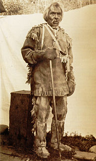
Tahltan, or Goon-da-chagga or Goon-tdar-shaga is an unincorporated locality and Indian Reserve community of the Tahltan people located west of Telegraph Creek in northern British Columbia, Canada, near the confluence of the Stikine and Tahltan Rivers. The local First Nations government is the Tahltan Band Council. The specific name of the Indian Reserve is Tahltan Indian Reserve No. 1. Other reserves in the immediate vicinity, also governed by this band, are Tahltan Forks Indian Reserve No. 5, Upper Tahltan Indian Reserve No. 4 and Hiusta's Meadow Indian Reserve No. 2.
The Stikine Plateau is a plateau in northern British Columbia, Canada. It lies between the Boundary Ranges of the Coast Mountains on the west and southwest and the Cassiar Mountains along its northeast, and between the Skeena Mountains on its south and southeast and the Jennings and Nakina Rivers on the north.
The Iskut First Nation is a band government of the Tahltan people. Their main reserve is Iskut IR No.6, located at Iskut, British Columbia; Kluachon Lake IR No.1 is in the same vicinity, while the band's third reserve, Stikine River IR No. 7 is located one mile west of, and on the opposite side of the Stikine River from, the community of Telegraph Creek. The Iskut First Nation is one of two member bands of the Tahltan Nation, the other member band being the Tahltan First Nation, also known as the Tahltan Indian Band.
The Klappan Coalbed Methane Project is a gas project owned by Shell Canada that looks to develop the coalbed methane from an area in northern British Columbia, near the source of three rivers: the Skeena River, Nass River, and Stikine River, and also the namesake Klappan River. The area is known in environmental politics and native lore as the Sacred Headwaters or Kablona. The project is the source of controversy and is opposed by First Nations groups and non-governmental organizations. If developed, the project will include a network of gas wells connected by roads and pipelines, as well as a pipeline to deliver the gas to market.
The Klastline Plateau is a plateau in the Stikine Country of the Northern Interior of British Columbia, Canada. A subplateau of the Stikine Plateau, it is located between the Stikine River (N), the upper Iskut River (S), Mess Creek (W) and the Klappan River (E). The Skeena Mountains are to the south, the Tahltan Highland to the west, the Spatsizi Plateau to the east, and the Tanzilla Plateau to the north, on the other side of the Stikine. The Spatsizi and Tanzilla Plateaus, and the Tahltan Highland, are also part of the Stikine Plateau.
The Chutine River, originally named the Clearwater River, is a major right tributary of the Stikine River in northwestern British Columbia, Canada. It is located west of the Stikine Icecap and just inside the boundary between Alaska and British Columbia. The former settlement of Chutine or Chutine Landing is located at the confluence of the Chutine and Stikine. The name means "half-people" in the Tahltan language.
Chutine, originally Chutine Landing, is an abandoned locality and is a former settlement at the confluence of the Chutine and Stikine Rivers in the Stikine Country of northwestern British Columbia, Canada. The name "Chutine" means "half-people" in the Tahltan language, as the community here was a mixture of Tahltan and Tlingit peoples.