
Kyle and Carrick was one of nineteen local government districts in the Strathclyde region of Scotland from 1975 to 1996.

The Rotten Calder is a river to the east of East Kilbride, South Lanarkshire, Scotland and along with the Rotten Burn it forms the southern and western boundaries of Blantyre.

Shinnel Water, also spelt Shinnell, is a river in the region of Dumfries and Galloway, Scotland.
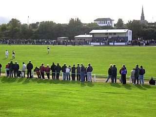
Girvan Football Club are a Scottish football club based in the town of Girvan, South Ayrshire. Nicknamed the Seasiders, they were formed in 1947 and play at Hamilton Park. They currently compete in West of Scotland League Conference A.

Straiton is a village on the River Girvan in South Ayrshire in Scotland, mainly built in the 18th century, but with some recent housing.

Meikle Auchengree is a hamlet near Kilbirnie and Longbar in North Ayrshire, Scotland.

The Water of Girvan is a river in South Ayrshire, which has its source at Loch Girvan Eye in the Carrick Forest section of Galloway Forest Park. This 28-mile (45-kilometre) river passes through the villages of Straiton, Kirkmichael and Dailly en route to the Firth of Clyde at Girvan Harbour.

The Caaf Water in western Scotland drains from the Caaf Reservoir above Dalry which is fed from Knockendon Reservoir. The Caaf Water's origins are springs below Green Hill and it is joined by the Bught Burn, the Reeves Burn, the Bradshaw Burn and the Stock Burn, passing the old Bradshaw shooting lodge before passing the old farms of Knockendon, Birkheadsteel, and Birkhead.

Closeburn is a village and civil parish in Dumfries and Galloway, Scotland. The village is on the A76 road 2+1⁄2 miles (4 km) south of Thornhill. In the 2001 census, Closeburn had a population of 1,119. Closeburn is recorded as Killosbern in 1185. The first element of the name is Gaelic cill 'cell or church'. The second element is a saint's name, but none has definitely been identified.
The Ladyburn distillery was a producer of single malt Scotch whisky that operated between 1966 and 1975.

Talla Water is a river in the Scottish Borders area of Scotland, near Tweedsmuir. It feeds the Talla Reservoir, and is a tributary of the River Tweed. Above the reservoir are a series of waterfalls known as the Talla Linns.

Drunmore Linn is a waterfall of Scotland, near Straiton, South Ayrshire.

Waukers Linn is a waterfall on Polharrow Burn in Dumfries and Galloway, Scotland.
Hespies Linn is a waterfall of Scotland.

Garpel Linn is a waterfall of Scotland.

The Tarf Water is a river in the former county of Wigtownshire in south-west Scotland. It rises on the Ayrshire border (55.0048°N 4.7815°W) and flows in a generally southeastward direction to meet the River Bladnoch near the village of Kirkcowan (54.9103°N 4.5792°W). It has no major tributaries but is fed by numerous burns which drain an area characterised by drumlins and much of which has been afforested.
The Girvan distillery is a lowland grain whisky distillery located in South Ayrshire, Scotland. The distillery is owned by William Grant & Sons. The Girvan Distillery is one of the largest facilities in Scotland in which whisky is made. The distillery is named after the town of Girvan. The distillery is known as one of the most energy efficient distilleries in Scotland.

Calderwood Castle was located in East Kilbride, Scotland. The castle was situated near the banks of the Rotten Calder Water in what is now Calderglen Country Park. Most likely constructed in the early to mid fifteenth century by the Maxwell family, the original peel tower collapsed in 1773. It was replaced by an extension to a large 18th-century country house called Calderwood House, which has itself since been demolished along with a later 1840s Gothic Revival addition.

Duchray Water, also called Dachray Water, is a 14-mile-long (23 km) headstream of the River Forth in the Trossachs region of Scotland.
 The start of Tairlaw Linn, the first of a set of waterfalls on the Water of Girvan close to Tairlaw Farm
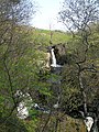 At the middle part of Tairlaw Linn – viewed here from the north bank through the woodland – the Water of Girvan splits into several short waterfalls. Below this, the waterfall makes a spectacular drop into a deep plunge pool.
