
Mombasa is a coastal city in southeastern Kenya along the Indian Ocean. It was the first capital of British East Africa, before Nairobi was elevated to capital status in 1907. It now serves as the capital of Mombasa County. The town is known as "the white and blue city" in Kenya. It is the country's oldest and second-largest city after Nairobi, with a population of about 1,208,333 people according to the 2019 census. Its metropolitan region is the second-largest in the country, and has a population of 3,528,940 people.
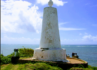
Malindi is a town on Malindi Bay at the mouth of the Sabaki River, lying on the Indian Ocean coast of Kenya. It is 120 kilometres northeast of Mombasa. The population of Malindi was 119,859 as of the 2019 census. It is the largest urban centre in Kilifi County.

Mijikenda are a group of nine related Bantu ethnic groups inhabiting the coast of Kenya, between the Sabaki and the Umba rivers, in an area stretching from the border with Tanzania in the south to the border near Somalia in the north. Archaeologist Chapuruka Kusimba contends that the Mijikenda formerly resided in coastal cities, but later settled in Kenya's hinterlands to avoid submission to dominant Portuguese forces that were then in control. Historically, these Mijikenda ethnic groups have been called the Nyika or Nika by outsiders. It is a derogatory term meaning "bush people."

The Coast Province was one of Kenya's eight provinces. It contained all of the country's coastline on the Indian Ocean. Its capital city was Mombasa. It was inhabited by the Mijikenda and Swahili peoples, among others. The province covered an area of 79,686.1 km2.
The Swahili people comprise mainly Bantu, Afro-Arab and Comorian ethnic groups inhabiting the Swahili coast, an area encompassing the Zanzibar archipelago and mainland Tanzania's seaboard, littoral Kenya, northern Mozambique, the Comoros Islands and Northwest Madagascar.

Kilifi is a town on the coast of Kenya, 56 kilometres (35 mi) northeast by road of Mombasa. The town lies on the Kilifi Creek and sits on the estuary of the Goshi River. Kilifi is the capital of Kilifi County and has a population of 122,899.

Pate (Paté) Island is located in the Indian Ocean close to the northern coast of Kenya, to which it belongs. It is the largest island in the Lamu Archipelago, which lie between the towns of Lamu and Kiunga in the former Coast Province. The island is almost completely surrounded by mangroves.

Watamu is a small town located approximately 105 km north of Mombasa and about 15 km south of Malindi on the Indian Ocean coast of Kenya. It lies on a small headland, between the Blue Lagoon and Watamu Bay. Its main economic activities are tourism and fishing. The town had a population of around 30,000 in 2020 and it is part of Kilifi County.

The Giriama are one of the nine ethnic groups that make up the Mijikenda.

The Chonyi, also referred to as Achonyi, are one of the smaller tribes of the Mijikenda on the coast of Kenya.
Kilifi County was formed in 2010 as a result of a merger of Kilifi District and Malindi District, Kenya. Its capital is Kilifi and its largest town is Malindi. Kilifi county is one of the five counties that make up the Kenyan Coast. The county has a population of 1,453,787 people following the 2019 census which covers an area of 12,245.90 km2 (4,728.17 sq mi).
The Segeju are a Bantu ethnolinguistic group mostly based in Tanzania's Tanga Region and Kenya's Kwale County. Most Segeju reside in the small coastal strip between the Tanzanian city of Tanga and the Kenyan-Tanzanian border. However, some Segeju have migrated to urban areas in other parts of Tanzania or Kenya, in hopes of better employment opportunities and quality of life. Segeju migration to urban areas often results in severance of community ties, leading to a lack of transmission of important cultural traditions and language.
Mnyazi wa Menza, also known as Mekatilili Wa Menza or Mekatilili (1860s-1924) was a Kenyan independence activist who led the Giriama people against the colonial administration of Kenya between 1912 and 1915.

The Bajuni people are a Bantu ethnic group who live primarily in the Bajuni Islands of Somalia and coastal areas between the port city of Kismayo and the city of Mombasa in Kenya. They relocated from Shungwaya (Somalia) to their current location due to war with Cushitic groups, who drove them out from their ancestral territory.
Mariakani is a town in Kenya lying on the boundary of Kaloleni and Kinango districts in the old Coast Province of Kenya, 36 kilometres northwest of the port city of Mombasa.

The Swahili coast is a coastal area of East Africa, bordered by the Indian Ocean and inhabited by the Swahili people. It includes Sofala ; Mombasa, Gede, Pate Island, Lamu, and Malindi ; and Dar es Salaam and Kilwa. In addition, several coastal islands are included in the Swahili coast, such as Zanzibar and Comoros.

Omanis are the nationals of Sultanate of Oman, located in the southeastern coast of the Arabian Peninsula. Omanis have inhabited the territory that is now Oman. In the eighteenth century, an alliance of traders and rulers transformed Muscat into the leading port of the Persian Gulf. Omani people are ethnically diverse; the Omani citizen population consists of many different ethnic groups. The majority of the population consists of Arabs, with many of these Arabs being Swahili language speakers and returnees from the Swahili Coast, particularly Zanzibar.
Mwanzele is a dance style originally performed during funerals by the Mijikenda tribe of the Coast Province of Kenya.
Chonyi is a Bantu language spoken along the eastern coast of Kenya in Kilifi County by the Chonyi people. It is part of the Mijikenda dialect cluster.
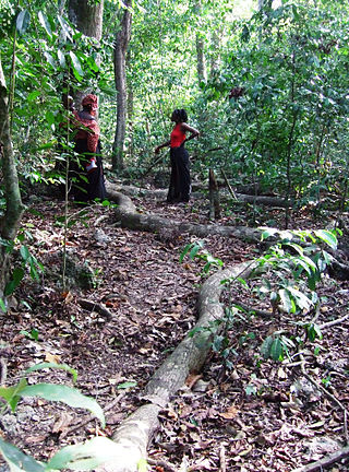
A kaya is a sacred site of the Mijikenda people in the former Coast Province of Kenya. Often located within sacred forests, a kaya is considered to be an intrinsic source of ritual power and the origin of cultural identity; it is also a place of prayer for members of the Mijikenda ethnic group. The settlement, ritual centre, and fortified enclosure associated with the forest are also part of the kaya. In the present day, the kaya is also referred to as a traditional organizational unit of the Mijikenda. Eleven of the approximately 60 separate makaya have been grouped together and inscribed as the Sacred Mijikenda Kaya Forests, a UNESCO World Heritage Site.