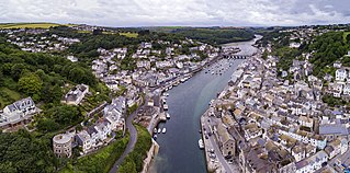
Looe is a coastal town and civil parish in south-east Cornwall, England, with a population of 5,280 at the 2011 census.
Bude is a seaside town in north east Cornwall, England, in the civil parish of Bude-Stratton and at the mouth of the River Neet. It was sometimes formerly known as Bude Haven. It lies southwest of Stratton, south of Flexbury and Poughill, and north of Widemouth Bay, located along the A3073 road off the A39. Bude is twinned with Ergué-Gabéric in Brittany, France. Bude's coast faces Bude Bay in the Celtic Sea, part of the Atlantic Ocean. The population of the civil parish can be found under Bude-Stratton.

Perranporth is a seaside resort town on the north coast of Cornwall, England, United Kingdom. It is 1 mile east of the St Agnes Heritage Coastline, and around 8 miles south-west of Newquay. Perranporth and its 3 miles (5 km) long beach face the Atlantic Ocean. It has a population of 3,066, and is the largest settlement in the civil parish of Perranzabuloe. It has an electoral ward in its own name, whose population was 4,270 in the 2011 census.
Penwith is an area of Cornwall, England, United Kingdom, located on the peninsula of the same name. It is also the name of a former local government district, whose council was based in Penzance. The area is named after one of the ancient administrative hundreds of Cornwall which derives from two Cornish words, penn meaning 'headland' and wydh meaning 'at the end'.

Godrevy is an area on the eastern side of St Ives Bay, west Cornwall, England, United Kingdom, which faces the Atlantic Ocean. It is popular with both the surfing community and walkers. It is part owned by the National Trust, and offshore on Godrevy Island is a lighthouse maintained by Trinity House which is said to be the inspiration for Virginia Woolf's novel To the Lighthouse. Godrevy lies within the Cornwall Area of Outstanding Natural Beauty (AONB) and the South West Coast Path runs around the whole promontory. There are several public car parks on the western side where the National Trust owns and operates a café.

Mount's Bay is a large, sweeping bay on the English Channel coast of Cornwall, United Kingdom, stretching from the Lizard Point to Gwennap Head. In the north of the bay, near Marazion, is St Michael's Mount; the origin of name of the bay. In summer, it is a large, benign, scenic, natural harbour. However, in winter, onshore gales present maritime risks, particularly for sailing ships. There are more than 150 known wrecks from the nineteenth century in the area. The eastern side of the bay centred around Marazion and St Michael's Mount was designated as a Marine Conservation Zone in January 2016.
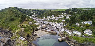
Polperro is a large village, civil parish, and fishing harbour within the Polperro Heritage Coastline in south Cornwall, England. Its population is around 1,554.

Fistral Beach is in Fistral Bay on the north coast of Cornwall, England, United Kingdom. It is situated half-a-mile west of Newquay at grid reference SW 797 620.
Trebetherick is a village on the north coast of Cornwall. It is situated on the east side of the River Camel estuary approximately six miles (10 km) north of Wadebridge and half a mile south of Polzeath.

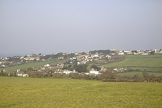
Harlyn is a small village on the north coast of Cornwall, England, United Kingdom. It is situated inland from Harlyn Bay three miles from Padstow and about one mile from St. Merryn.
Praa Sands, commonly pronounced pray or prah, is a white-sand beach and coastal village in Cornwall, England. It is in the parish of Breage and lies off the A394 road between Helston and Penzance. Formerly serving the local mining industry, it is now mostly a tourist-orientated area. The beach is popular with surfers and walkers. Towards the south eastern end of the beach is a WW2 Type 24 pillbox. Originally this was constructed on top of the cliffs but it has been subjected to coastal erosion and has settled down onto the beach.

Gunwalloe is a coastal civil parish in Cornwall, England, United Kingdom. It is situated on the Lizard Peninsula three miles (4.8 km) south of Helston and partly contains The Loe, the largest natural freshwater lake in Cornwall. The parish population including Berepper at the 2011 census was 219. The hamlets in the parish are Chyanvounder, Berepper and Chyvarloe. To the east are the Halzephron cliffs and further east the parish church.

The Manacles are a set of treacherous rocks off The Lizard peninsula in Cornwall. The rocks are rich in marine wildlife and they are a popular spot for diving due to the many shipwrecks. Traditionally pronounced mean-a'klz (1808), the name derives from the Cornish meyn eglos, the top of St Keverne church spire being visible from the area.

Talland is a hamlet and ecclesiastical parish between Looe and Polperro on the south coast of Cornwall. It is in the civil parish of Polperro and consists of a church, the Old Vicarage and a few houses.
Carlyon Bay is a bay and a set of three beaches near St Austell on the south coast of Cornwall, England, United Kingdom. It is located approximately 2 miles (3 km) east of the town centre.

Nanjizal, also known as Mill Bay, is a beach and cove in the civil parish of St Levan, Cornwall, United Kingdom. Situated one mile to the south-east of Land's End, Nanjizal has no direct access via road, and is usually reached via the South West Coast Path from Land's End in the north, or from Porthgwarra to the south. Nanjizal is also a noted bird watching location.

New Polzeath is a coastal settlement immediately north-east of Polzeath in north Cornwall, England, United Kingdom. It is situated approximately 5 miles (8.0 km) north-northwest of Wadebridge at grid reference SW 935 794.
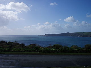
St Ives Bay is a bay on the Atlantic coast of north-west Cornwall, England, United Kingdom. It is in the form of a shallow crescent, some 4 miles or 6 km across, between St Ives in the west and Godrevy Head in the east.

Talland Church is a Grade I listed building located on the cliff-top at Talland near Looe in Cornwall. It is dedicated to St Tallanus and was built by Augustinian monks from Launceston.

Towan Head is a headland one mile west of Newquay on the north coast of Cornwall, United Kingdom. It is at the western end of Newquay Bay. The headland points north and Fistral Beach is immediately to the south.

