Tamdybulak

Last updated
Tamdybulak
Тамдыбулақ, Tamdibulaq
Town
Tamdybulak
Uzbekistan adm location map.svg
Red pog.svg
Tamdybulak
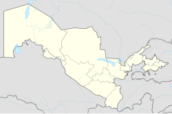
Location in Uzbekistan
Coordinates: 41°45′N64°37′E / 41.750°N 64.617°E / 41.750; 64.617
Country Flag of Uzbekistan.svg  Uzbekistan
Region Navoiy Region
District Tamdy District
Elevation
[1]
297 m (974 ft)
Population
 (2022)
  Total5,000
Time zone UTC+5 (UZT)

Tamdybulaq, sometimes also written as Tamdybulak, is an urban-type settlement and seat of Tamdy District in Navoiy Region in Uzbekistan. [2] Its population is 5,000 (2022 est.). [3]

Contents

Geography

Tamdybulak lies in the Kyzyl Kum desert, a flat, arid plain with scattered sand dunes.

Transportation

Tamdybulak is served by the Tamdy Bulak Airport. [4]

Roads from the town lead southwest to Zarafshan, southeast to Ayakkuduk, and north to Sukuti and Keriz.

Climate

Tamdybulak has a desert climate (Köppen climate classification BWk), with cold winters and very hot summers. Rain is light and sporadic, and usually occurs from November to May.

Climate data for Tamdybulak (1991-2020, extremes 1932-present)
MonthJanFebMarAprMayJunJulAugSepOctNovDecYear
Record high °C (°F)22.8
(73.0)
28.0
(82.4)
34.0
(93.2)
40.1
(104.2)
43.1
(109.6)
46.0
(114.8)
48.4
(119.1)
45.8
(114.4)
42.7
(108.9)
38.2
(100.8)
30.9
(87.6)
22.5
(72.5)
48.4
(119.1)
Mean daily maximum °C (°F)3.1
(37.6)
6.2
(43.2)
14.9
(58.8)
22.9
(73.2)
30.3
(86.5)
36.0
(96.8)
37.8
(100.0)
36.0
(96.8)
29.5
(85.1)
21.2
(70.2)
11.1
(52.0)
4.4
(39.9)
21.1
(70.0)
Daily mean °C (°F)−1.1
(30.0)
1.1
(34.0)
8.6
(47.5)
16.3
(61.3)
23.4
(74.1)
29.2
(84.6)
31.2
(88.2)
29.1
(84.4)
22.3
(72.1)
14.2
(57.6)
5.7
(42.3)
0.1
(32.2)
15.0
(59.0)
Mean daily minimum °C (°F)−4.6
(23.7)
−3.2
(26.2)
3.2
(37.8)
10.2
(50.4)
16.8
(62.2)
22.0
(71.6)
24.1
(75.4)
22.0
(71.6)
15.4
(59.7)
8.1
(46.6)
1.1
(34.0)
−3.6
(25.5)
9.3
(48.7)
Record low °C (°F)−28.2
(−18.8)
−30.1
(−22.2)
−24.9
(−12.8)
−8.0
(17.6)
0.4
(32.7)
7.0
(44.6)
11.6
(52.9)
7.4
(45.3)
−1.8
(28.8)
−11.1
(12.0)
−24.8
(−12.6)
−28.2
(−18.8)
−30.1
(−22.2)
Average precipitation mm (inches)11
(0.4)
15
(0.6)
17
(0.7)
15
(0.6)
14
(0.6)
5
(0.2)
2
(0.1)
2
(0.1)
0.4
(0.02)
4
(0.2)
13
(0.5)
12
(0.5)
110
(4.3)
Average extreme snow depth cm (inches)1
(0.4)
2
(0.8)
0
(0)
0
(0)
0
(0)
0
(0)
0
(0)
0
(0)
0
(0)
0
(0)
0
(0)
1
(0.4)
2
(0.8)
Average rainy days44664211124439
Average snowy days6410.1000000.12417.2
Average relative humidity (%)72665644362825253041607146
Mean monthly sunshine hours 110.6144.0195.8244.6317.9350.6396.2378.0315.8252.0156.6110.52,972.6
Source 1: Pogoda.ru.net [5]
Source 2: NOAA [6]

Related Research Articles

<span class="mw-page-title-main">Navoiy</span> City in Navoiy Region, Uzbekistan

Navoiy, also spelled Navoi, is a city and the capital of Navoiy Region in the southwestern part of Uzbekistan. Administratively, it is a district-level city, that includes the urban-type settlement Tinchlik. It is located at latitude 40° 5' 4N; longitude 65° 22' 45E, at an altitude of 382 meters. The city is named after Ali-Shir Nava'i. As of 2020, its population was 144,158 inhabitants.

Batken is a town in southwestern Kyrgyzstan, on the southern fringe of the Fergana Valley. It is the administrative seat of Batken Region. Since 2000, it is a city of regional significance, i.e. not part of a district. However, it is still the administrative seat of Batken District. Its area is 205 square kilometres (79 sq mi), and its resident population was 27,730 in 2021. The population of the town proper was 15,805.

<span class="mw-page-title-main">Zarafshon</span> Place in Navoiy Region, Uzbekistan

Zarafshon is a city in the center of Uzbekistan's Navoiy Region. Administratively, it is a district-level city, that includes the urban-type settlement Muruntau. It has an area of 20 km2 (7.7 sq mi) and it has 85,100 inhabitants (2021). Located in the Kyzylkum desert, it receives water from the Amudarya by a 220-km pipeline.

<span class="mw-page-title-main">Samarqand Region</span> Region of Uzbekistan

Samarqand Region is the most populous region of Uzbekistan. It is located in the center of the country in the basin of the Zarafshan River. It borders Tajikistan, Navoiy Region, Jizzakh Region and Qashqadaryo Region. It covers an area of 16,773 km². The population is estimated to be around 4,031,324, with some 63% living in rural areas (2022).

<span class="mw-page-title-main">Bukhara Region</span> Region of Uzbekistan

Bukhara Region is a region of Uzbekistan located in the southwest of the country. The Kyzyl Kum desert takes up a large portion of its territory. It borders Turkmenistan, Navoiy Region, Qashqadaryo Region, a small part of the Xorazm Region, and the Karakalpakstan Republic. It covers an area of 40,216 km2. The population is estimated at 1,976,823 (2022), with 63% living in rural areas.

<span class="mw-page-title-main">Navoiy Region</span> Region of Uzbekistan

Navoiy Region is one of the regions of Uzbekistan. It is located in the central north/northwest of the country. It covers an area of 111,095 km2 (42,894 sq mi), which makes it the largest of the regions of Uzbekistan. The Navoiy region borders with Kazakhstan, Samarqand Region, Buxoro Region, Jizzakh Region, and the Karakalpakstan Republic. The population is estimated 1,033,857 (2022), with 51% living in rural areas. The capital is Navoiy. The region and its capital are named after the poet Ali-Shir Nava'i.

<span class="mw-page-title-main">Razzakov</span> Town in Batken, Kyrgyzstan

Razzakov, formerly known as Isfana, is a small town in the extreme western end of Batken Region in southern Kyrgyzstan. The town is located in the southern part of the Fergana Valley, in a region surrounded on three sides by Tajikistan. It was renamed by President Sadyr Japarov in honour of Iskhak Razzakov on March 18, 2022.

Kyzyl-Kyya is a city in Batken Region, in southwestern Kyrgyzstan. It is a city of regional significance, not part of a district, and consists of the town proper and the villages Karavan, Ak-Bulak and Jin-Jigen. Its area is 78 square kilometres (30 sq mi), and its resident population was 56,819 in 2021. It is situated on the southern edge of the Fergana Valley, 32 km southeast of Fergana, and 65 km southwest of Osh. The town is one of the oldest centers of the coal mining industry in Kyrgyzstan.

<span class="mw-page-title-main">Naryn District</span> District in Naryn Region, Kyrgyzstan

Naryn District is a district of Naryn Region in central-southern Kyrgyzstan. The administrative seat lies at the city Naryn, which is not part of the district. Naryn District was established in its borders in 1930. It borders with At-Bashy District to the south, Ak-Talaa District to the west, Kochkor District to the north, Tong District to the north-east, Jeti-Ögüz District to the east, and Lake Song Köl to the north-west. Its area is 10,502 km2 (4,055 sq mi), and its resident population was 49,955 in 2021.

<span class="mw-page-title-main">Ellikqala District</span> District in Karakalpakstan, Uzbekistan

Ellikqala District is a district of Karakalpakstan in Uzbekistan. The capital lies at the city Boʻston. Its area is 5,420 km2 (2,090 sq mi) and it had 164,600 inhabitants in 2022.

<span class="mw-page-title-main">Kenimekh district</span> District in Navoiy Region, Uzbekistan

Kenimekh district is a district of Navoiy Region in Uzbekistan. The capital lies at the town Kenimekh. It has an area of 9,250 km2 (3,570 sq mi) and its population is 36,200. The district consists of 5 urban-type settlements and 7 rural communities. Until 2018, when it became part of Kenimekh district, the town Zafarobod was part of the Gʻijduvon District.

<span class="mw-page-title-main">Karmana District</span> District in Navoiy Region, Uzbekistan

Karmana District is a district of Navoiy Region in Uzbekistan. The capital lies at the town Karmana. It has an area of 950 km2 (370 sq mi) and its population is 128,200. The district consists of 5 urban-type settlements and 7 rural communities.

<span class="mw-page-title-main">Qiziltepa District</span> District in Navoiy Region, Uzbekistan

Qiziltepa District is a district of Navoiy Region in Uzbekistan. The capital lies at the city Qiziltepa. It has an area of 2,190 km2 (850 sq mi) and its population is 153,900. The district consists of one city (Qiziltepa), 12 urban-type settlements and 8 rural communities.

<span class="mw-page-title-main">Xatirchi District</span> District in Navoiy Region, Uzbekistan

Xatirchi District is a district of Navoiy Region in Uzbekistan. The capital lies at the city Yangirabod. It has an area of 1,420 km2 (550 sq mi) and its population is 201,900.

<span class="mw-page-title-main">Navbahor District</span> District in Navoiy Region, Uzbekistan

Navbahor District is a district of Navoiy Region in Uzbekistan. The capital lies at the village Beshrabot. It has an area of 1,570 km2 (610 sq mi) and its population is 114,700. The district consists of 5 urban-type settlements and 7 rural communities.

<span class="mw-page-title-main">Nurota District</span> District in Navoiy Region, Uzbekistan

Nurota District is a district of Navoiy Region in Uzbekistan. The capital lies at the city Nurota. It has an area of 5,940 km2 (2,290 sq mi) and its population is 85,200.

<span class="mw-page-title-main">Tomdi District</span> District in Navoiy Region, Uzbekistan

Tomdi District is a district of Navoiy Region in Uzbekistan. The capital lies at the town Tomdibuloq. It has an area of 42,490 km2 (16,410 sq mi) and its population is 15,100. The district consists of one urban-type settlements (Tomdibuloq) and 7 rural communities.

<span class="mw-page-title-main">Uchquduq District</span> District in Navoiy Region, Uzbekistan

Uchquduq District is a district of Navoiy Region in Uzbekistan. The capital lies at the city Uchquduq. It has an area of 46,630 km2 (18,000 sq mi) and its population is 37,700. The district consists of one city (Uchquduq), one urban-type settlement (Shalxar) and 5 rural communities.

<span class="mw-page-title-main">Shofirkon District</span> District in Bukhara Region, Uzbekistan

Shofirkon District is a district of Bukhara Region in Uzbekistan. The capital lies at the city Shofirkon. It has an area of 3,720 km2 (1,440 sq mi) and its population is 181,700 (2021).

Gʻozgʻon is a district-level city in Navoiy Region, Uzbekistan. It has an area of 590 km2 (230 sq mi) and it has 8,800 inhabitants (2021). The town population in 1989 was 4,728 people.

References

  1. "Tomdibuloq, Uzbekistan". Falling Rain Global Gazetteer. Retrieved 30 January 2013.
  2. "Classification system of territorial units of the Republic of Uzbekistan" (in Uzbek and Russian). The State Committee of the Republic of Uzbekistan on statistics. July 2020.
  3. "Urban and rural population by district" (PDF) (in Uzbek). Navoiy regional department of statistics.
  4. "Tandy Bulak Airport". OurAirports. Retrieved 30 January 2013.
  5. КЛИМАТ УЛАН-БАТОРА (in Russian). Pogoda.ru.net. Retrieved 4 January 2015.
  6. "Climate Normals for Fergana". National Oceanic and Atmospheric Administration. Retrieved 1 November 2023.