Tang Valley

Last updated

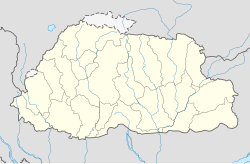
Tang Valley is one of the four valleys of Bumthang District, Bhutan. [1]

Contents

Tang Valley
Bhutan location map.svg
Red pog.svg
Tang Valley
Coordinates: 27°45′8″N90°40′40″E / 27.75222°N 90.67778°E / 27.75222; 90.67778 Coordinates: 27°45′8″N90°40′40″E / 27.75222°N 90.67778°E / 27.75222; 90.67778
Area
  Total562.00 ha (1,388.74 acres)
Elevation
2,800 - 5,000 m (−13,600 ft)
Population
  Total1,816
Time zone UTC+6 (Bhutan Time)

It is located 11 km away from Jakar, the administrative center of Bumthang District, Bhutan. It trails higher up the lake called Mebartsho. [2]
Etymology

Guru Rinpoche in his attempt to subdue Khikha Rathoe, a son of Trisong Detsen, flew Khikha Rathoe and his ministers on a wooden aeroplane. As the aeroplane flew higher it caught on fire and Guru Rimpoche landed it on a rock at a valley in Bumthang. It is believed that the valley was named after the sound the aeroplane made on landing: 'Tang'. [3]

Related Research Articles

<span class="mw-page-title-main">Thimphu</span> Capital of Bhutan

Thimphu is the capital and largest city of Bhutan. It is situated in the western central part of Bhutan, and the surrounding valley is one of Bhutan's dzongkhags, the Thimphu District. The ancient capital city of Punakha was replaced as capital by Thimphu in 1955, and in 1961 Thimphu was declared as the capital of the Kingdom of Bhutan by the 3rd Druk Gyalpo Jigme Dorji Wangchuck.

<span class="mw-page-title-main">Bumthang District</span> District of Bhutan

Bumthang District is one of the 20 dzongkhag (districts) comprising Bhutan. It is the most historic dzongkhag if the number of ancient temples and sacred sites is counted. Bumthang consists of the four mountain valleys of Ura, Chumey, Tang and Choekhor ("Bumthang"), although occasionally the entire district is referred to as Bumthang Valley.

Kuensel is the national newspaper of the Kingdom of Bhutan. It was the only local newspaper available in Bhutan until 2006 when two more newspapers were launched. The government of Bhutan owns 51% of Kuensel while 49% is held by the public.

The Kheng people are found primarily in the Zhemgang, Trongsa, Bumthang, Dagana, and Mongar Districts of central Bhutan. They speak the Kheng language, a member of the extended Tibetan language family belonging to the East Bodish languages group; it is mutually intelligible with the Bumthang language and Kurtöp language to the north. The Kheng people are ethnolinguistically same as the Bumthang people and Kurtöp people of central Bhutan and are more closely related to Ngalop people of western Bhutan than to their neighbors in eastern Bhutan, who are primarily Sharchops and speak Tshangla language. SIL International estimates there are 50,000 Kheng speakers as of 2009.

<span class="mw-page-title-main">Paro, Bhutan</span> Place in Paro District, Bhutan

Paro is a town and seat of Paro District, in the Paro Valley of Bhutan. It is a historic town with many sacred sites and historical buildings scattered throughout the area. It is also home to Paro Airport, Bhutan's sole international airport.

<span class="mw-page-title-main">Tamzhing Monastery</span> Tibetan Buddhist monastery in Bumthang District, Bhutan

Tamzhing Lhündrup Monastery in Bumthang District in central Bhutan is a Nyingma gompa in Bhutan. Its temple and monastery are remarkable for their direct connection to the Bhutanese tertön and saint, Pema Lingpa (1450-1521) and his tulkus. It is now the seat of Sungtrul Rinpoche, the current speech incarnation of Pema Lingpa.

<span class="mw-page-title-main">Jakar</span> Thromde in Bumthang, Bhutan

Jakar is a town in the central-eastern region of Bhutan. It is the district capital of Bumthang District and the location of Jakar Dzong, the regional dzong fortress. The name Jakar roughly translates as "white bird" in reference to its foundation myth, according to which a roosting white bird signalled the proper and auspicious location to found a monastery around 1549.

<span class="mw-page-title-main">Architecture of Bhutan</span> Overview of the architecture in Bhutan

Bhutanese architecture consists of Dzong and everyday varieties. Dzongs in Bhutan were built as fortresses and have served as religious and administrative centers since the 17th century. Secular lordly houses emerged as a distinct style in the late 19th century, during a period of relative peace in Bhutan. Throughout its history, Bhutan has mainly followed the Tibetan tradition of Buddhist architecture.

<span class="mw-page-title-main">Languages of Bhutan</span>

There are two dozen languages of Bhutan, all members of the Tibeto-Burman language family except for Nepali, which is an Indo-Aryan language, and Bhutanese Sign Language. Dzongkha, the national language, is the only native language of Bhutan with a literary tradition, though Lepcha and Nepali are literary languages in other countries. Other non-Bhutanese minority languages are also spoken along Bhutan's borders and among the primarily Nepali-speaking Lhotshampa community in South and East Bhutan. Chöke is the language of the traditional literature and learning of the Buddhist monastics.

<span class="mw-page-title-main">Jakar Dzong</span> Fortress and Buddhist monastery of the Bumthang District in central Bhutan

Jakar Dzong or Jakar Yugyal Dzong is the dzong or fortress of the Bumthang District in central Bhutan. It is located on a ridge above Jakar town in the Chamkhar valley of Bumthang. It is built on the site of an earlier temple established by the Ralung hierarch Yongzin Ngagi Wangchuk (1517–1554) when he came to Bhutan. Jakar Dzong may be the largest dzong in Bhutan, with a circumference of more than 1,500 metres (4,900 ft).

<span class="mw-page-title-main">Paro Taktsang</span> Tibetan Buddhist temple complex in the Paro valley, Bhutan

Paro Taktsang, is a sacred Vajrayana Himalayan Buddhist site located in the cliffside of the upper Paro valley in Bhutan. It is one of thirteen Tiger's Nest caves in historical Tibet in which Padmasambhava practiced and taught Vajrayana.

<span class="mw-page-title-main">Trongsa Dzong</span>

Trongsa Dzong is the largest dzong fortress in Bhutan, located in Trongsa in Trongsa district, in the centre of the country. Built on a spur overlooking the gorge of the Mangde River, a temple was first established at the location in 1543 by the Drukpa lama, Nagi Wangchuk son of Ngawang Chhojey. In 1647, his great-grandson Shabdrung Ngawang Namgyal, constructed the first dzong to replace it, called Chökhor Rabtentse Dzong with a shorter version of Choetse Dzong. It was enlarged several times during the 18th century; the Chenrezig Lhakang was built in 1715 and a whole complex, including the Maitreya (Jampa) temple, was added in 1771. The dzong has since been repaired on several occasions; it was damaged during the 1897 Assam earthquake and underwent extensive renovation in 1927 and 1999.

Ta Rimochan or Ti Rimochen is a Buddhist monastery in Bhutan belonging to the Nyingma school of Tibetan Buddhism.

The Tang Chuu is a tributary of the Mo Chhu in western Bhutan.

The Kingdom of Bumthang was one of several small kingdoms within the territory of modern Bhutan before the first consolidation under Zhabdrung Ngawang Namgyal in 1616. After initial consolidation, the Bumthang Kingdom became Bumthang Province, one of the nine Provinces of Bhutan. The region was roughly analogous to modern-day Bumthang District. It was again consolidated into the modern Kingdom of Bhutan in 1907.

<span class="mw-page-title-main">Thrumshing La</span>

Thrumshing La, also called Thrumshingla Pass and Donga Pass,, is the second-highest mountain pass in Bhutan, connecting its central and eastern regions across the otherwise impregnable Donga range that has separated populations for centuries. It is located on a bend of the Lateral Road at the border of Bumthang District and Mongar District, along the border with Lhuntse District to the east. The Lateral Road bisects Thrumshingla National Park, named after the pass. The World Wildlife Fund also maintains operations in the park.

<span class="mw-page-title-main">Valleys of Bhutan</span>

The valleys of Bhutan are carved into the Himalaya by Bhutan's rivers, fed by glacial melt and monsoon rains. As Bhutan is landlocked in the mountainous eastern Himalaya, much of its population is concentrated in valleys and lowlands, separated by rugged southward spurs of the Inner Himalaya. Despite modernization and development of transport in Bhutan, including a national highway system, travel from one valley to the next remains difficult. Western valleys are bound to the east by the Black Mountains in central Bhutan, which form a watershed between two major river systems, the Mo Chhu and the Drangme Chhu. Central valleys are separated from the east by the Donga Range. The more isolated mountain valleys protect several tiny, distinct cultural and linguistic groups. Reflecting this isolation, most valleys have their own local protector deities.

<span class="mw-page-title-main">Military history of Bhutan</span>

The military history of Bhutan begins with the Battle of Five Lamas in 1634, marking Bhutan's emergence as a nation under the secular and religious leadership of Zhabdrung Ngawang Namgyal. Before Bhutan emerged as a separate nation, it remained on the periphery of Tibetan military and political influence. The region that became Bhutan was host to several battles and waves of refugees from turmoil in Tibet. After its founding, Bhutan was invaded numerous times by outside forces, namely Tibetans, Mongols, and the British. Bhutan meanwhile invaded its traditional tributaries in Sikkim, Cooch Behar, and the Duars.

<span class="mw-page-title-main">Trashigang Dzong</span> Dzong fortress in Trashigang, Bhutan

Trashigang Dzong is one of the largest dzong fortress in Bhutan, located in Trashigang in Trashigang District of Bhutan. The fortress was built in 1659 to defend against Tibetan invasions. The dzong hosted a monastic community besides acting as the central administrative center of the Trashigang District, before they were shifted due to the ongoing restoration.

<span class="mw-page-title-main">Membartsho</span> Holy site in Bhutan

Membartsho, also known as Mebar Tsho, is a holy site, revered as the place where Pema Lingpa, Bhutan's greatest tertön, discovered several of Guru Rinpoche's terma in the 15th century. The pool in the Tang Valley, near Bumthang in central Bhutan is known locally as the Burning Lake, because according to legend, Pema Lingpa had a dream urging him to go to that particular spot in the Tang Chuu river. After standing on the rocks looking into the depths he discerned there was a temple at the bottom with many doors, one of which was open. He dove in and swam into a large cave where a woman with one eye handed him a treasure chest. As he took it from her he found himself back on dry land.

References

  1. "Tang Valley, Bumthang Bhutan". www.windhorsetours.com. Retrieved 2020-06-11.
  2. "Tang Valley travel". Lonely Planet. Retrieved 2020-06-11.
  3. Wangdi, Nima. “Palace of the Exiled Tibetan Prince.” Kuensel Online, Kuensel, 27 Dec. 2016, https://kuenselonline.com/palace-of-the-exiled-tibetan-prince/.

Resource