Related Research Articles

Victoria Island is a large island in the Arctic Archipelago that straddles the boundary between Nunavut and the Northwest Territories of Canada. It is the eighth-largest island in the world, and at 217,291 km2 (83,897 sq mi) in area, it is Canada's second-largest island. It is nearly double the size of Newfoundland (111,390 km2 [43,010 sq mi]), and is slightly larger than the island of Great Britain (209,331 km2 [80,823 sq mi]) but smaller than Honshu (225,800 km2 [87,200 sq mi]). The western third of the island lies in the Inuvik Region of the Northwest Territories; the remainder is part of Nunavut's Kitikmeot Region. The population of 2,168 is divided among 2 settlements, the larger of which is in Nunavut and the other of which is in the Northwest Territories.

Lake County is a county located in the northwest part of the U.S. state of Montana. As of the 2020 census, the population was 31,134. Its county seat is Polson.

Brades is a town and the de facto capital of Montserrat since 1998 with an approximate population of 1,000.

Galloway Road, also known as West 87th Avenue, is a north–south route through the western areas of suburban Miami-Dade County, Florida, from the Black Point area south of Cutler Bay almost to the Broward County line north of Miami Lakes. It exists in seven different unconnected segments that total 27.5 miles (44.3 km) in length, acting as connecting roads, neighborhood streets, and arterial routes. Approximately 9.5 miles (15.3 km) of Galloway Road, between Pinecrest and Doral, is designated as State Road 973.

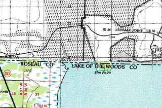
Elm Point, Minnesota, is a small uninhabited cape and a practical exclave of the United States in Lake Township, Roseau County, Minnesota, United States. It is surrounded on the west, south, and east by Lake of the Woods, and on the north by the Canadian First Nation community of Buffalo Point in southeastern Manitoba. Part of Elm Point is privately owned and part of it is state land managed by the Department of Natural Resources as part of the Border Wildlife Management Area. It is located southwest of the much larger exclave known as the Northwest Angle. There is a line of felled trees marking the international border, which runs nominally along the 49th parallel, although in this area it runs slightly to the south due to 19th-century surveying errors.

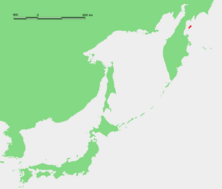
Karaginsky Island or Karaginskiy Island is an island in the Karaginsky Gulf of the Bering Sea. The 40 km (25 mi)-wide strait between the Kamchatka Peninsula and this island is called Litke Strait. Karaginsky Island is a Ramsar site.
The Ossipee Mountains are a small mountain range in the New England state of New Hampshire, United States. The remains of an ancient volcanic ring dike, they lie north of Lake Winnipesaukee, east of Squam Lake, and south of the Sandwich Range, the southernmost of the White Mountains. 2,990 ft (910 m) Mount Shaw is their highest point.

Cutler Stack is a conspicuous sea stack extending 170 by 150 m and rising to 16 m (52 ft), lying off Ivanov Beach in the south of Barclay Bay, western Livingston Island in the South Shetland Islands, Antarctica. The area was visited by early 19th century sealers.
Nunatakassak is a nunatak in Avannaata municipality in northwestern Greenland. It is one of several nunataks in the Melville Bay region of Greenland, where the Greenland ice sheet drains into the bay alongside its entire length apart from an occasional nunatak.
Nekoro Bay or Baie Nekoro is a bay in southwestern New Caledonia. It lies just northwest of Porwi Bay. The town of Nepoui and Nepoui Airport lie on the coast at Nekoro Bay. The bay contains Grimault Island and Hiyé Hiyé Island. Blancbe Bay lies just to the northwest.
Chasseloup Bay or Baie Chasseloup is a bay in northwestern New Caledonia. It lies northwest of Katavilli Bay and southeast of Gomen Bay. The town of Voh lies to the east of the bay. Several rivers empty into the bay. A small coral reef with a least depth of 5 feet lies 1200 yards westward of the middle of the head of Chasseloup Bay. Puangue Channel is westward of Chasseloup bay and forms a curve about 2J miles in length. It is reportedly the only way within the outer reef by which a vessel can pass to the northward. Anchorage in the bay is said to be good.
Gomen Bay or Baie Gomen is a bay in northwestern New Caledonia. It lies northwest of Chasseloup Bay and southeast of Ohland Bay. The village of Kaala Gomen lies near the bay.
Ohland Bay or Baie Ohland Bay is a bay in northwestern New Caledonia. It lies northwest of Gomen Bay and just southeast of Nehoue Bay. The village of Paagoumene lies on the bay.
Nehoue Bay or Baie de Néhoué is a bay in northwestern New Caledonia. It lies just northwest of Ohland Bay and just southeast of Tanle Bay. The village of Malabou lies on the bay which contains the Malabou Beach Hotel. This resort lies 45 kilometres northwest of Koumac and is noted for its white sands. The bay contains numerous islands, the largest of which is Boh Island. Tanle Island lies just to the west in front of the channel of Tanle Bay. Other islands include Neangambo Island, Ti Island and Ti-Ac Island.
Banare Bay or Baie de Banare is a bay in far northwestern New Caledonia. It lies northwest of Tanle Bay. Poum lies on the southern part of the bay and Tiabet lies on the northern part. The bay contains several islands. Mouac Island lies just north of Poum, others islands include Pionne Island and Yava Island and further out is the larger Neba Island.
The Shag Islands are a small group of islands in the southern part of Coppett Harbour, off the south coast of Newfoundland, Canada. They lie to the east of Bonalds Island. The southernmost island, Shag Island, is described as "a conspicuous white rock, 12.8m high".
Maravovo is a village on the northwest coast of Guadalcanal, Solomon Islands. It is located 57.6 kilometres (35.8 mi) by road northwest of Honiara. Mangakiki is in close proximity to Maravovo. The population is reportedly entirely Anglican. On 7 October 1942, during the Guadalcanal campaign, the Japanese established a small midget submarine base there. On 7 February 1943, when the first American troops reached the area, they only encountered slight resistance, and found out most of the Japanese had already been previously evacuated during Operation Ke. Wreck of one of the midget submarine still lies underwater in the bay facing the village.

Helnæs is an island on the southwestern coast of Funen, Denmark, southwest of Haarby and northwest of Faaborg. It belongs administratively to Assens Municipality and is connected to the town of Assens by road to the north.

Ambon Bay is a bay that located in Ambon island, Maluku province, Indonesia. The bay separates Ambon island into two peninsulas; the southeastern and smaller peninsula is called Leitimur, while the larger northern peninsula is called Leihitu or Hitoe. These peninsulas are connected by a narrow neck of land on the eastern part of the island. The bay opens to the Banda Sea in the southwest direction. The Ambon Bay thus formed cuts about 20 kilometres into the island with the airport on the northern shore and the city of Ambon on the southern side. The city of Ambon covers the entirety of Leitimur, with its centre on the northwest coast of Leitimur, facing Leihitu, and has a safe harbor on Amboina Bay.

Hog Island is an island in the San Joaquin River, and is one of many islands which constitute the Sacramento–San Joaquin River Delta. It was used for agriculture in the early 20th century, but has now mostly become marsh or submerged land; it remains a spot for fishing, particularly halibut and striped bass.
References
- ↑ Google. "Tanle Bay" (Map). Google Maps . Google.