
Myanmar is the northwesternmost country of mainland Southeast Asia located on the Indochinese peninsula. With an area of 261,228 sq mi (676,578 km2), it is the second largest country in Southeast Asia and the largest on mainland Southeast Asia. The kite-shaped country stretches from 10'N to 20'N for 1,275 miles (2,050 km) with a long tail running along the western coast of the Malay Peninsula.

The Wa people are a Southeast Asian ethnic group that lives mainly in Northern Myanmar, in the northern part of Shan State and the eastern part of Kachin State, near and along Myanmar's border with China, as well as in China's Yunnan Province.

Mae Hong Son province, also spelled Maehongson, Mae Hong Sorn or Maehongsorn, is one of Thailand's seventy-six provinces (changwat). It lies in upper northern Thailand and is the westernmost province. Neighboring provinces are Shan State of Myanmar, Chiang Mai and Tak. To the west, the province borders Kayin State and Kayah State of Myanmar.

Shan State is a state of Myanmar. Shan State borders China (Yunnan) to the north, Laos to the east, and Thailand to the south, and five administrative divisions of Myanmar in the west. The largest of the 14 administrative divisions by land area, Shan State covers 155,800 km2, almost a quarter of the total area of Myanmar. The state gets its name from Burmese name for the Tai peoples: "Shan people". The Tai (Shan) constitute the majority among several ethnic groups that inhabit the area. Shanland is largely rural, with only three cities of significant size: Lashio, Kengtung, and the capital, Taunggyi. Taunggyi is 150.7 km northeast of the nation's capital Naypyitaw.

Wa State is an autonomous self-governing polity in Myanmar (Burma). It is de facto independent from the rest of the country and has its own political system, administrative divisions and army. While the Wa State government recognises Myanmar's sovereignty over all of its territory, this does not include allegiance to any specific government. The 2008 Constitution of Myanmar officially recognises the northern part of Wa State as the Wa Self-Administered Division of Shan State. As a one-party socialist state ruled by the United Wa State Party (UWSP), which split from the Communist Party of Burma (CPB) in 1989, Wa State is divided into three counties, two special districts, and one economic development zone. The administrative capital is Pangkham, formerly known as Pangsang. The name Wa is derived from the Wa ethnic group, who speak an Austroasiatic language.
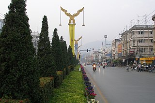
Mae Sai is the northernmost district (amphoe) of Chiang Rai province in northern Thailand. The town of Mae Sai is a major border crossing between Thailand and Myanmar. Asian Highway Network AH2 crosses the Mae Sai River to the town Tachileik in Myanmar.

Lweje is a town in Kachin State in northeastern Burma, across the China-Myanmar border from Zhangfeng, in Longchuan County, Yunnan Province, China. It is one of five official border trade posts with China.

The following outline is provided as an overview of and topical guide to Myanmar:

Sidoktaya, also Sitoktaya or Setoketaya is a town and seat of Sidoktaya Township in Minbu District of Magway Division, situated in middle west region of Burma. It is bordered with Salin township to the east, with Pwintbyu township to the south-east, with Ngape township to the south, with Minbya township to the west, with Kanpelek township to the north-west and with Saw township to the north. It is a hilly region of Rakhine. Mount Sun Taung, the highest mountain in Rakhine, 6,527 feet (1,989 m) high, is in Sidoktaya township.
Wa (Va) is an Austroasiatic language spoken by the Wa people of Myanmar and China. There are three distinct varieties, sometimes considered separate languages; their names in Ethnologue are Parauk, the majority and standard form; Vo and Awa, though all may be called Wa, Awa, Va, Vo. David Bradley (1994) estimates there are total of 820,000 Wa speakers.
Wa Kyun is an island in the Andaman Sea, right off the coast of Mon State, in the southern area of Burma. This 2 kilometres (1.2 mi) long island is located in the midst of a shoal or shallow area. It is covered with dense forest and rises to a height of 135 metres (443 ft).

Preparis Island is an island which is part of the Yangon Region of Myanmar. Together, with the other Andaman Islands, it marks the boundary between the Bay of Bengal and the Andaman Sea. The island has a population of 50 and a total area of 8.1 km2 (3.1 sq mi).
Mong Ling Shan, also known as Möng Ling Shan, is one of the highest mountains of the Shan Hills. It is located in the Namtit Special District of Wa State, Myanmar close to the border with China and 122 km to the ENE of Lashio. It is the highest peak in Myanmar Shan State.

The Kaladan Road Project is a US$484 million project connecting the eastern Indian seaport of Kolkata with Sittwe seaport in Rakhine State, Myanmar by sea. In Myanmar, it will then link Sittwe seaport to Paletwa in Chin State via the Kaladan river boat route, and then from Paletwa by road to Mizoram state in Northeast India. All components of the project, including Sittwe port and power, river dredging, Paletwa jetty, have been completed, except the under construction Zorinpui-Paletwa road. Originally, the project was scheduled to be completed by 2014, but end-to-end project is expected to be fully operational only by December 2023 as per November 2023 update.
Taklu is a village in Hopang District, Wa Self-Administered Division of Myanmar.

The Wa States was the name formerly given to the Wa Land, the natural and historical region inhabited mainly by the Wa people, an ethnic group speaking an Austroasiatic language. The region is located to the northeast of the Shan States of British Burma, in the area of present-day Shan State of northern Myanmar (Burma) and the western zone of Pu'er Prefecture, Yunnan, China.

The China–Myanmar border is the international border between the territory of the People's Republic of China and Myanmar. The border is 2,129 km (1,323 mi) in length and runs from the tripoint with India in the north to the tripoint with Laos in the south.
Pan Lon is the capital of Panlong Subtownship, Hopang District, in the Wa Self-Administered Division of Myanmar.
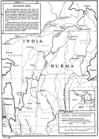
The India–Myanmar border is the international border between India and Myanmar. The border is 1,643 kilometres (1,021 mi) in length and runs from the tripoint with China in the north to the tripoint with Bangladesh in the south.
The 1988 Lancang–Gengma earthquakes, also known as the 11.6 earthquakes by the Chinese media were a pair of devastating seismic events that struck Lancang and Gengma counties, Yunnan, near the border with Shan State, Burma. The earthquake measured moment magnitude (Mw ) 7.0 and was followed 13 minutes later by a 6.9 Mw shock. These earthquakes were assigned a maximum China seismic intensity of IX and X, respectively. Between 748 and 939 people were killed; more than 7,700 were injured. Both earthquakes resulted in US$270 million in damage and economic losses. Moderately large aftershocks continued to rock the region, causing additional casualties and damage.
