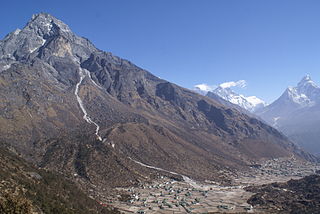
Khumjung is a village in Khumbu Pasanglhamu rural municipality of Solukhumbu District in Province No. 1 of north-eastern Nepal. It is located in the Khumbu subregion inside Sagarmatha National Park, a world heritage site. The village is at an elevation of 3,790 metres above sea level, and is situated near Mount Khumbila.

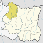
Solukhumbu District (Nepali: सोलुखुम्बु जिल्ला[solukʰumbu], Sherpa: ཤར་ཁུམ་བུ་རྫོང་།, Wylie: shar khum bu dzong) is one of 14 districts of Province No. 1 of eastern Nepal. As the name suggests, it consists of the subregions Solu and Khumbu.

Solududhkunda (earlier:Dudhkunda) is the only municipality of Solukhumbu District. Located in Province No. 1 of Nepal. The town of Salleri, which is located within the municipality is the headquarter of Solukhumbu District It was formed in 2014 by merging four VDCs: Salleri, Garma, Loding Tamakhani and Beni and was divided into 9 wards. Total area of the municipality had 254.3 square kilometres (98.2 sq mi) and population of municipality had 20,399 individuals living in 5,368 households.
Saudiyar is a town and Village Development Committee in Dang Deokhuri District in Lumbini Province of south-western Nepal. At the time of the 1991 Nepal census it had a population of 8,052 persons living in 1067 individual households.
Parche is a town and Village Development Committee in Kaski District in the Gandaki Zone of northern-central Nepal. At the time of the 1991 Nepal census it had a population of 3,182 persons living in 669 individual households.
Jarbuta is a village development committee in Surkhet District in the Bheri Zone of mid-western Nepal. At the time of the 1991 Nepal census it had a population of 5243 people living in 949 individual households. As of the 2011 Nepal census it had a population of 8580 people living in 1,837 individual households.
Baku is a village development committee (VDC) in Solukhumbu District in the Sagarmatha Zone of north-eastern Nepal. Baku lies in the Himalaya, 59 km South of Mount Everest and is bordered by the valleys of Dudh Kosi River (West) and Hinku Drangka River (East). At the time of the 1991 Nepal census it had a population of 4159 people living in 777 individual households. At the 2011 census, the population of the VDC Baku was 4844 inhabitants in 963 individual households.
Beni is a village development committee in Solukhumbu District in the Sagarmatha Zone of north-eastern Nepal. At the time of the 1991 Nepal census it had a population of 1927 people living in 352 individual households.
Chaulakharka is a village development committee in Solukhumbu District in the Sagarmatha Zone of north-eastern Nepal. At the time of the 1991 Nepal census it had a population of 1839 people living in 372 individual households.
Chheskam is a village development committee in Solukhumbu District in the Sagarmatha Zone of north-eastern Nepal. At the time of the 1991 Nepal census it had a population of 2824 people living in 641 individual households.
Garma (गार्मा) is a village development committee in Solukhumbu District in the Sagarmatha Zone of north-eastern Nepal. At the time of the 1991 Nepal census it had a population of 2398 people living in 473 individual households.
Jubu is a village development committee in Solukhumbu District in the Sagarmatha Zone of north-eastern Nepal. At the time of the 1991 Nepal census it had a population of 3544 people living in 706 individual households.
Kaku, Nepal is a village development committee in Solukhumbu District in the Sagarmatha Zone of north-eastern Nepal. At the time of the 1991 Nepal census it had a population of 3896 people living in 750 individual households.
Kerung is a village development committee in Solukhumbu District in the Sagarmatha Zone of north-eastern Nepal. At the time of the 2011 Nepal census, it had a population of 3,602 people living in 873 individual households.
Pawai, Nepal is a village development committee in Solukhumbu District in the Sagarmatha Zone of north-eastern Nepal. At the time of the 1991 Nepal census it had a population of 2180 people living in 425 individual households.
Taksindu is a village development committee (VDC) in Solukhumbu District in the Sagarmatha Zone of north-eastern Nepal. At the time of the 2011 Nepal census it had a population of 2177 people living in 510 individual households. Of the total population 1,065 (48.9%) were male and 1,172 (53.8%) were female( p 20). The VDC has seven wards, they are Chhulemu, Hewa, Deku, Nunthala, Akang, Ringbu, and Changa. There are several ethnic groups residing in the area, among them Sherpa, Rai, and Tamang. The VDC is multilingual as the residents speak Sherpa, Rai, Tamang and Nepali languages. Major economic activity of the area are tourism, animal husbandry and agricultural production.
Nele is a village development committee in Solukhumbu District in the Sagarmatha Zone of north-eastern Nepal. At the time of the 1991 Nepal census it had a population of 2021 people living in 364 individual households.
Panchan, Nepal is a village development committee in Solukhumbu District in the Sagarmatha Zone of north-eastern Nepal. At the time of the 1991 Nepal census it had a population of 1698 people living in 318 individual households.

Salyan, Solukhumbu is a village development committee in Solukhumbu District in the Sagarmatha Zone of north-eastern Nepal. At the time of the 1991 Nepal census it had a population of 5307 people living in 1034 individual households. It has been merged into Necha Salyan Gaupalika.
Sundar Haraicha is a municipality in Morang District of Province No. 1 in Nepal. It is centered around Biratchowk town which is the gateway to Biratnagar. It borders Itahari Sub- Metropolitan city to the West, Dharan Sub- Metropolitan city to the Northwest and Belbari municipality to the East and is connected by the Mahendra Highway. It is one of the fastest growing cities in the Eastern Nepal and the second largest city of Morang district after Biratnagar with 121,305 inhabitants living in 26,677 households. It consists the town centres of Biratchowk and Gothgaun which are parts of the Greater Birat Development Area which incorporates the cities of Biratnagar-Itahari-Gothgau-Biratchowk-Dharan primarily located on the Koshi Highway in Eastern Nepal, with an estimated total urban agglomerated population of 804,300 people living in 159,332 households.