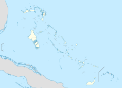
Tarpum Bay

Last updated

Tarpum Bay is one of the larger settlements on the island of Eleuthera in the Bahamas. A settlement is typically a small (often un-incorporated) town or village. Tarpum Bay is known for its vibrantly colored buildings and large waterside Anglican church. Local fishermen sell their catch daily at one of the two fishing docks.

Coordinates: 24°59′N76°10′W / 24.983°N 76.167°W / 24.983; -76.167


Related Research Articles

Victoria Island (Canada) Island in arctic Canada

Victoria Island is a large island in the Arctic Archipelago that straddles the boundary between Nunavut and the Northwest Territories of Canada. It is the eighth largest island in the world, and at 217,291 km2 (83,897 sq mi) in area, it is Canada's second largest island. It is nearly double the size of Newfoundland (111,390 km2 [43,008 sq mi]), and is slightly larger than the island of Great Britain (209,331 km2 [80,823 sq mi]) but smaller than Honshu (225,800 km2 [87,182 sq mi]). It contains the world's largest island within an island within an island. The western third of the island lies in the Inuvik Region of the Northwest Territories; the remainder is part of Nunavut's Kitikmeot Region.

Arctic Archipelago Group of islands in the Arctic Ocean, off the coast of northern Canada

The Arctic Archipelago, also known as the Canadian Arctic Archipelago, is an archipelago lying to the north of the Canadian continental mainland, excluding Greenland.

Kenai Peninsula Large peninsula in south central Alaska, United States

The Kenai Peninsula is a large peninsula jutting from the coast of Southcentral Alaska. The name Kenai is derived from the word "Kenaitze" or "Kenaitze Indian Tribe", the name of the Native Athabascan Alaskan tribe, the Kahtnuht’ana Dena’ina, who historically inhabited the area. They called the Kenai Peninsula Yaghanen.

Baffin Bay A marginal sea between Greenland and Baffin Island, Canada

Baffin Bay, located between Baffin Island and the west coast of Greenland, is defined by the International Hydrographic Organization as a marginal sea of the Arctic Ocean. It is sometimes considered a sea of North Atlantic Ocean. It is connected to the Atlantic via Davis Strait and the Labrador Sea. The narrower Nares Strait connects Baffin Bay with the Arctic Ocean. The bay is not navigable most of the year because of the ice cover and high density of floating ice and icebergs in the open areas. However, a polynya of about 80,000 km2 (31,000 sq mi), known as the North Water, opens in summer on the north near Smith Sound. Most of the aquatic life of the bay is concentrated near that region.

St. Marys River (Maryland)

The St. Marys River is a 22.3-mile-long (35.9 km) river in southern Maryland in the United States. It rises in southern St. Mary's County, and flows to the southeast through Great Mills, widening into a tidal estuary near St. Mary's City, approximately 2 miles (3 km) wide at its mouth on the north bank of the Potomac River, near the Chesapeake Bay to the east.

Port Mayaca, Florida

Port Mayaca is a sparsely populated place located in western Martin County, Florida, United States, on the eastern side of Lake Okeechobee.

Port Antonio Place in Surrey, Jamaica

Port Antonio is the capital of the parish of Portland on the northeastern coast of Jamaica, about 100 km from Kingston. It had a population of 12,285 in 1982 and 13,246 in 1991. It is the island's third largest port, famous as a shipping point for bananas and coconuts, as well as one of its most important tourist attractions, tourism being a major contributor to the town’s economy.

Machar Colony or Machiara Colony is an unplanned settlement in Karachi, Pakistan, located near the Port of Karachi and Lyari. The settlement is spread over an area of almost 4 square kilometers, and is home to about 150,000 people. It is considered to be one of the most dilapidated slums in Karachi.

South Eleuthera

South Eleuthera is one of the districts of the Bahamas, on the island of Eleuthera.

Cargan

Cargan is a small village and townland in County Antrim, Northern Ireland. It lies at the foot of Slievenanee in Glenravel – locally known as "The Tenth Glen" along with the more widely known nine Glens of Antrim. It is part of Mid and East Antrim district. It had a population of 588 people in the 2011 Census.

Bache Peninsula

Bache Peninsula is a geological formation in Canada, on Ellesmere Island in Nunavut. The peninsula is considered a cape', meaning that it is a headland that dramatically affects the ocean currents. It is primarily known for being the site of the world's northernmost permanent settlement from 1926 to 1933, a Royal Canadian Mounted Police post.

Morant Cays

Morant Cays is an offshore island group 51 km SSE off Morant Point, Jamaica. They are one of two offshore island groups belonging to Jamaica, the other ones being the Pedro Cays. They are located at 17°24′N75°59′W and consist of four small islets grouped closely together along the southeastern rim of Morant Bank a comparatively extensive crescent-shaped bank of coral, over 7 km long, rising from 1000 m. The area of Morant Bank is about 100 km². The aggregate land area of the four cays is only 16.0 hectares or 39.5 acres. Morant Cays are low-lying, mostly uninhabited, seasonally visited by fishermen, and fronted by highly exposed reefs over which the sea constantly breaks.

Maxcanú is a large town in the western part of the Mexican state of Yucatán; it also functions as the seat for the Maxcanú Municipality. It is located on Federal Highway 180, approximately 62 km (38.5 mi) south of Mérida.

German submarine <i>U-68</i> (1940)

German submarine U-68 was a Type IXC U-boat of Nazi Germany's Kriegsmarine during World War II. The submarine was laid down on 20 April 1940 at the DeSchiMAG AG Weser yard at Bremen as yard number 987, launched on 22 October and commissioned on 1 January 1941 under the command of Korvettenkapitän Karl-Friedrich Merten as part of 2nd U-boat Flotilla.

The Glacier Strait is a natural waterway through the Canadian Arctic Archipelago within Qikiqtaaluk Region, Nunavut, Canada. It separates Ellesmere Island from Coburg Island. To the north-east it opens into Baffin Bay, and to the south-west into the Jones Sound.

Adzopé Department Department in Lagunes, Ivory Coast

Adzopé Department is a department of La Mé Region in Lagunes District, Ivory Coast. In 2014, its population was 193,518 and its seat is the settlement of Adzopé. The sub-prefectures of the department are Adzopé, Agou, Annépé, Assikoi, Bécédi-Brignan, and Yakassé-Mé.

McMorrin Glacier is a glacier flowing west from Mount Metcalfe to Marguerite Bay in Graham Land, Antarctica. it was named by the UK Antarctic Place-Names Committee for Ian McMorrin, a British Antarctic Survey general assistant at Stonington Island, 1961–63, who helped survey this area in 1962.

Lennon Glacier is a glacier flowing southwest into the outer part of Lazarev Bay, in northern Alexander Island, Antarctica. It was surveyed by the British Antarctic Survey (BAS), 1975–76, and was named by the UK Antarctic Place-Names Committee in 1980 after BAS glaciologist Peter Wilfred Lennon, who worked on Alexander Island, 1974–76.

Division No. 1, Subdivision G, Newfoundland and Labrador Unorganized territory in Newfoundland and Labrador, Canada

Division No. 1, Subdivision G is an unorganized subdivision on the Avalon Peninsula in Newfoundland and Labrador, Canada. It is in Division 1 and contains the unincorporated communities of Baccalieu Island, Besom Cove, Bradley's Cove, Burnt Point, Caplin Cove, Daniel's Cove, Grates Cove, Gull Island, Job's Cove, Kingston, Long Beach, Lower Island Cove, Low Point, Northern Bay, Ochre Pit Cove, Red Head Cove, Riverhead, Smooth Cove and Western Bay.

La Mé Region in Lagunes, Ivory Coast

La Mé Region is one of the 31 regions of Ivory Coast. Since its establishment in 2011, it has been one of three regions in Lagunes District. The seat of the region is Adzopé and the region's population in the 2014 census was 514,700.