
The Guadalcanal campaign, also known as the Battle of Guadalcanal and codenamed Operation Watchtower by American forces, was a military campaign fought between 7 August 1942 and 9 February 1943 on and around the island of Guadalcanal in the Pacific theater of World War II. It was the first major land offensive by Allied forces against the Empire of Japan.

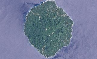
Guadalcanal is the principal island in Guadalcanal Province of the Solomon Islands, located in the south-western Pacific, northeast of Australia. It is the largest island in the Solomon Islands by area, and the second by population. The island is mainly covered in dense tropical rainforest and has a mountainous interior.

USS New Orleans (CL/CA-32) was the lead New Orleans-class cruiser in service with the United States Navy. The New Orleans-class cruisers were the last U.S. cruisers built to the specifications and standards of the Washington Naval Treaty of 1922. Such ships, with a limit of 10,000 long tons (10,160 t) standard displacement and 8-inch (203-millimetre) calibre main guns may be referred to as "treaty cruisers." Originally classified a light cruiser, because of her thin armor, she was reclassified, soon after being laid down, a heavy cruiser, because of her 8-inch guns. The term "heavy cruiser" was not defined until the London Naval Treaty in 1930.

The Naval Battle of Guadalcanal, sometimes referred to as the Third and Fourth Battles of Savo Island, the Battle of the Solomons, the Battle of Friday the 13th, or, in Japanese sources, the Third Battle of the Solomon Sea, took place from 12–15 November 1942, and was the decisive engagement in a series of naval battles between Allied and Imperial Japanese forces during the months-long Guadalcanal Campaign in the Solomon Islands during World War II. The action consisted of combined air and sea engagements over four days, most near Guadalcanal and all related to a Japanese effort to reinforce land forces on the island. The only two U.S. Navy admirals to be killed in a surface engagement in the war were lost in this battle.

USS De Haven (DD-469) was a Fletcher-class destroyer of the United States Navy, the first Navy ship named for Lieutenant Edwin J. De Haven USN (1819–1865). De Haven was the first Fletcher-class ship lost in World War II, having been in commission only 133 days.

The Battle of Tassafaronga, sometimes referred to as the Fourth Battle of Savo Island or, in Japanese sources, as the Battle of Lunga Point (ルンガ沖夜戦), was a nighttime naval battle that took place on November 30, 1942, between United States Navy and Imperial Japanese Navy warships during the Guadalcanal Campaign. The battle took place in Ironbottom Sound near the Tassafaronga area on Guadalcanal.

"Ironbottom Sound" is the name given by Allied sailors to the stretch of water at the southern end of The Slot between Guadalcanal, Savo Island, and Florida Island of the Solomon Islands, because of the dozens of ships and planes that sank there during the Battle of Guadalcanal in 1942–43. Before the war, it was called Savo Sound. Every year on the battle's anniversary, a U.S. ship cruises into the waters and drops a wreath to commemorate the men who lost their lives. For many Navy sailors, and those who served in the area during that time, the waters in this area are considered sacred, and strict silence is observed as ships cruise through.

USS Honolulu (CL-48) of the United States Navy was a Brooklyn-class light cruiser active in the Pacific War. Honolulu was launched in 1937 and commissioned in 1938. The ship served in the Battle of Tassafaronga, the Battle of Kula Gulf, the Battle of Kolombangara and the Battle of Peleliu. She was taken out of action by serious torpedo damage just before the Battle of Leyte Gulf. She was repaired, but not in time to rejoin the war. She was decommissioned in 1947 and was held in reserve until she was scrapped in 1959.

USS Northampton (CL/CA-26) was the lead Northampton-class cruiser in service with the United States Navy. She was commissioned in 1930, originally classified a light cruiser because of her thin armor but later reclassified a heavy cruiser because of her 8-inch guns. During World War II she served in the Pacific and was sunk by Japanese torpedoes during the Battle of Tassafaronga on 30 November 1942. She was named after the city of Northampton, Massachusetts, the home of former President Calvin Coolidge.
Savo Island is an island in Solomon Islands in the southwest South Pacific ocean. Administratively, Savo Island is a part of the Central Province of the Solomon Islands. It is about 35 kilometres (22 mi) from the capital Honiara. The principal village is Alialia, in the north of the island.

The Battle of Cape Esperance, also known as the Second Battle of Savo Island and, in Japanese sources, as the Sea Battle of Savo Island (サボ島沖海戦), took place on 11–12 October 1942, in the Pacific campaign of World War II between the Imperial Japanese Navy and United States Navy. The naval battle was the second of four major surface engagements during the Guadalcanal campaign and took place at the entrance to the strait between Savo Island and Guadalcanal in the Solomon Islands. Cape Esperance (9°15′S159°42′E) is the northernmost point on Guadalcanal, and the battle took its name from this point.

The Russell Islands are two small islands, as well as several islets, of volcanic origin, in the Central Province of Solomon Islands. They are located approximately 48 kilometres northwest of Guadalcanal. The islands are partially covered in coconut plantations, and have a copra and oil factory at Yandina. Yandina also has basic services, including a store, post office, and airport.
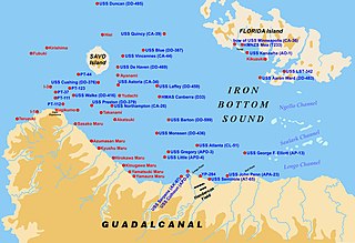
In the Solomon Islands, the waters between the Florida Islands and Taivu Point on the northeast of Guadalcanal are divided by reefs into Nggela Channel, Sealark Channel, and Lengo Channel. They connect Ironbottom Sound to the west with Indispensable Strait to the east.

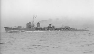
Suzukaze was the tenth and final vessel of ten Shiratsuyu-class destroyers, and the fourth to be built for the Imperial Japanese Navy under the Circle Two Program.
Natsugumo was the seventh of ten Asashio-class destroyers built for the Imperial Japanese Navy in the mid-1930s under the Circle Two Supplementary Naval Expansion Program.
Takanami (高波) was a Yūgumo-class destroyer of the Imperial Japanese Navy. Her name means "Tall Wave".
Cape Esperance is the northernmost point on Guadalcanal, Solomon Islands. The Battle of Cape Esperance, one of several naval engagements fought in the waters north of the island during the World War II Guadalcanal campaign, took its name from this point. In 1943, Cape Esperance was the site of the final Japanese withdrawal of troops from the island after six months of fierce resistance against occupying US Marines.

The Matanikau River of Guadalcanal, Solomon Islands, is located in the northwest part of the island. During the World War II Guadalcanal campaign, several significant engagements occurred between United States and Japanese forces near the river.
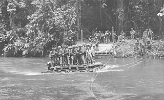
The Matanikau Offensive, from 1–4 November 1942, sometimes referred to as the Fourth Battle of the Matanikau, was an engagement between United States (U.S.) Marine and Army and Imperial Japanese Army forces around the Matanikau River and Point Cruz area on Guadalcanal during the Guadalcanal campaign of World War II. The action was one of the last of a series of engagements between U.S. and Japanese forces near the Matanikau River during the campaign.

The Guadalcanal American Memorial is a World War II monument on Guadalcanal in Solomon Islands. Dedicated on August 7, 1992, it was established as a tribute to the Americans and their allies who lost their lives during the Guadalcanal Campaign from 7 August 1942 to 9 February 1943. The capital city of Honiara is to its north. To mark the 50th anniversary of the Red Beach landings, the U.S. War Memorial was dedicated on 7 August 1992. An account of this is also inscribed on red marble tablets inside the monument compound. The memorial was a joint effort of the American Battle Monuments Commission (ABMC) and the Guadalcanal-Solomon Islands Memorial Commission, and was at the initiative of Robert F Reynolds, Chief of Valors Tours Ltd. The memorial is maintained by the ABMC. Every year on 7 August, a commemorative ceremony is held to mark the first day of the battle. Another monument, erected by the Japanese on Mount Austen, is a tribute to the Japanese who lost their lives.
