Related Research Articles

Scoria is a highly vesicular, dark-colored volcanic rock that may or may not contain crystals (phenocrysts). It is typically dark in color, and basaltic or andesitic in composition. Scoria is relatively low in density as a result of its numerous macroscopic ellipsoidal vesicles, but in contrast to pumice, all scoria has a specific gravity greater than 1, and sinks in water. The holes or vesicles form when gases that were dissolved in the magma come out of solution as it erupts, creating bubbles in the molten rock, some of which are frozen in place as the rock cools and solidifies. Scoria may form as part of a lava flow, typically near its surface, or as fragmental ejecta, for instance in Strombolian eruptions that form steep-sided scoria cones. Chemical analysis of scoria found in Yemen showed that it was mainly composed of volcanic glass with a few zeolites. Most scoria is composed of glassy fragments and may contain phenocrysts. The word scoria comes from the Greek σκωρία, skōria, rust. A colloquial term for scoria is cinder.
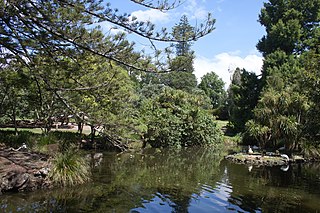
The Auckland Domain is a large park in Auckland, New Zealand. It is the oldest park in the city, and at 75 hectares is one of the largest. Located in the central suburb of Grafton, the park contains all of the explosion crater and most of the surrounding tuff ring of the Pukekawa volcano.

The Panmure Basin, also sometimes known as the Panmure Lagoon, is a tidal estuary within a volcanic crater or maar in New Zealand's Auckland volcanic field, which erupted approximately 25,200 years ago. It is located to the south of Panmure town centre.
Hurupaki Mountain is in Kamo, Whangarei, New Zealand. The centre of Hurupaki Mountain lies between Three Mile Bush Road and Dip Road, approximately 1.5 kilometres west of Kamo township. Hurupaki Mountain is visible from State Highway 1.

Mangere Lagoon is a lagoon in the Manukau Harbour, New Zealand. It occupies a volcanic crater or maar which is part of the Auckland volcanic field. Oval and about 600m long, it has a small restored scoria island remaining in the centre.

Lake Tauanui is a lake in the Northland Region of New Zealand. North of the lake is Tauanui volcanic scoria cone.

Maungataketake is one of the volcanoes in the Auckland volcanic field in New Zealand. It had a 76 m high scoria cone, beside a 100 m wide crater, before they were quarried away. It was the site of a pā. Layers of volcanic tuff and ash from Maungataketake overlay the fallen trunks of the nearby Ihumatao fossil forest.

Mount Saint John is a volcanic scoria cone in Epsom, in the Auckland volcanic field of New Zealand. It has a peak 126 metres above sea level and a crater around 150 m wide. It was the site of a pā, and has retained Māori earthworks from that era such as kumara pits and terracing. The age of Mount St John is currently unknown but is older than 28,500 years old as the scoria cone is mantled in ash from Te Tatua-a-Riukiuta volcano.

Taylors Hill, is a volcano in the Auckland volcanic field. It erupted about 33,000 years ago. Its scoria cone reaches 56 m high.

Little Rangitoto is a volcano in the Auckland volcanic field in Remuera, New Zealand.

Robertson Hill is one of the volcanoes in the Auckland volcanic field in New Zealand.

Hampton Park is one of the volcanoes in the Auckland volcanic field. A small scoria cone reaching 35 metres above sea level, with a shallow crater around 50 metres wide, which has been modified by quarrying. The scoria cone sits in the centre of a much larger explosion crater, the eastern arc of the surrounding tuff ring is still present. Stone from the volcano was used to build dry-stone walls and the nearby St John's Church built on the tuff ring crest.

The Kaikohe-Bay of Islands volcanic field is in the Northland Region of New Zealand. Eruptions have occurred over the last 10 million years. All the cones older than 2 million years have eroded away, leaving plateaus from Ōkaihau to Kerikeri and north to Whangaroa. In the southern part of the field, around 12 small basaltic scoria cones, and a rhyolite dome erupted in the last 500,000 years around Kaikohe. The field is considered dormant, rather than extinct.
Te Ahuahu is a 373 m high basaltic scoria cone, in the Kaikohe-Bay of Islands volcanic field in New Zealand.
Pouerua is a 270 m high basaltic scoria cone, in the Kaikohe-Bay of Islands volcanic field in New Zealand. It is in the locality of Pakaraka and was the site of a pā that was studied during a major archeological project in the 1980s. Pouerua is registered with the Historic Places Trust as a traditional site.
Te Puke is a 136 metres (446 ft) high group of basaltic scoria cones, in the Kaikohe-Bay of Islands volcanic field in Northland, New Zealand. It is the easternmost volcano of the field, being located near Waitangi. The three or four small, cratered cones are in a southwest–northeast alignment. The last eruption was 1300 to 1800 years ago.
Maungaturoto is a 282 m high basaltic scoria cone, in the Kaikohe-Bay of Islands volcanic field in New Zealand. It was the site of a pā.
Tarahi is a 388 m high basaltic scoria cone, in the Kaikohe-Bay of Islands volcanic field in New Zealand. Northwest of Tarahi is a smaller, 350 m scoria cone, Haruru pā.

Te Tātua-a-Riukiuta is a volcano in Three Kings, New Zealand that erupted 28,500 years ago. The volcano had three prominent peaks and a number of smaller peaks until most of them were quarried away, leaving a sole remaining large peak.
Licto is a volcanic field in Ecuador, close to the town of Licto.
References
Coordinates: 35°29′32″S173°51′31″E / 35.492263°S 173.8586°E
| | This Northland Region-related geography article is a stub. You can help Wikipedia by expanding it. |