
Bruneck (German pronunciation: [ˈbrʊnɛk]; Italian: Brunico[bruˈniːko] or [ˈbruːniko] Ladin: Bornech or Burnech; Latin: Branecium or Brunopolis is the largest town in the Puster Valley in the Italian province of South Tyrol.

The Rienz is a river in South Tyrol, Italy. Its source is located at 2,180 m of altitude, in the Dolomites mountains, south of Toblach: near Toblach it enters in the Puster Valley, and, after 90 km (56 mi), it meets the Eisack river in the city of Brixen, at 550 m of altitude.

The Puster Valley is one of the largest longitudinal valleys in the Alps that runs in an east-west direction between Lienz in East Tyrol, Austria and Mühlbach near Brixen in South Tyrol, Italy. The South Tyrolean municipalities of the Puster Valley constitute the Puster Valley district.
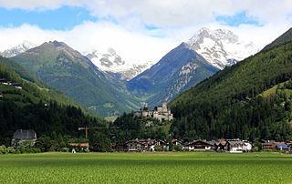
Sand in Taufers is a comune mercato in South Tyrol in northern Italy.

Gais is a comune (municipality) in South Tyrol in northern Italy, located about 60 kilometres (37 mi) north-east of the city of Bolzano.

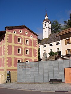
Prettau is a comune (municipality) in South Tyrol, a province in northern Italy, located about 80 kilometres (50 mi) northeast of Bolzano, on the border with Austria.

Rasen-Antholz is a municipality in South Tyrol in northern Italy.

Mühlwald is a comune (municipality) in South Tyrol, a province in northern Italy, located about 60 kilometres (37 mi) northeast of Bolzano, on the border with Austria.
Ahrntal is a comune (municipality) in South Tyrol in northern Italy, located about 70 kilometres (43 mi) northeast of the city of Bolzano (Bozen), on the border with Austria.

Luttach is a mountain village in northern Italy. It is a frazione of the comune of Ahrntal in South Tyrol.

The Tauferer Bahn connected Taufers with the city of Bruneck and the Pusterer Bahn.

The Ahr is a river in South Tyrol, Italy, which flows through the Tauferer Ahrntal.

The Reinbach is a stream in South Tyrol, Italy, known as the Rio di Riva in Italian. It flows into the Ahr in Sand in Taufers. It has three waterfalls, two 50 metres (160 ft) high, and one 10 metres (33 ft) high, all located in the Rieserferner-Ahrn Nature Park. The river is also a popular kayaking spot.

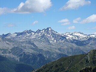
Speikboden is a massif in the Central Eastern Alps located between the three valleys Weißenbach, Mühlwald and Ahrntal. Running in a south-easterly direction, it forms the eastern part of an outlier of the western Zillertal Alps. Its highest point, likewise named Speikboden, is 2,517 m. Further well-known peaks in this massif include Seewassernock (2,516 m), Große Nock (2,400 m), Kleine Nock (2,227 m) and Gornerberg (2,475 m).

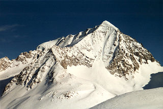
The Venediger Group is a mountain range of the Central Eastern Alps. Together with the Granatspitze Group, the Glockner Group, the Goldberg Group, and the Ankogel Group, it forms the main ridge of the High Tauern. The highest peak is the Großvenediger at 3,657 m (AA), which gives its name to the group. Considerable parts of the Venediger Group belong to the core zone of the High Tauern National Park.
The Rieserferner Group is a mountain range in the Austrian Central Alps. Together with the Ankogel Group, Goldberg Group, Glockner Group, Schober Group, Kreuzeck Group, Granatspitze Group, Venediger Group and the Villgraten Mountains the group is part of the High Tauern. The Rieserferner mountains extend across the Austrian state of Tyrol and the Italian province of South Tyrol. The mountains mainly lie in South Tyrol, where the greater part is protected within the Rieserferner-Ahrn Nature Park.

The Rauhkofel or Rauchkofel is a summit on the main crest of the Zillertal Alps, which forms the border between the Austrian state of Tyrol and the Italian province of South Tyrol. The name of the mountain comes from the rugged appearance of the granite blocks that form the summit. The Rauhkofel rises above its neighbouring peaks on the main Zillertal ridge considerably and it is considered the best lookout mountain in the eastern Zillertal Alps. The east and south arêtes of the Rauhkofel are part of the main crest of the Zillertal Alps. Another ridge runs from the summit heading northwest; on its continuation at a distance of just under two kilometres is the Kleinspitze. North of the summit are the remnants of the Rauhkofelkees glacier. At the southwestern foot of the peak is the Waldner See, the largest lake in the Ahrntal valley.
The Napfspitze, is a peak on the main chain of the Zillertal Alps and on the border between the Austrian federal state of Tyrol and the Italian province of South Tyrol.

The Durreck Group in South Tyrol is an independent mountain range within the Venediger Group. To the north and west it is bounded by the Tauferer Ahrntal, behind which the peaks of the Zillertal Alps stand. To the south it is separated by the valley of Reintal from the Rieserferner Group. The Ochsenlenke (2,623 m) forms the eastern end of the Durreck Group where the rocky ridge drops to almost 2,600 m and completely disappears under the rolling depositional landscape. From the Schneespitze (2,925 m) the first peaks and glaciers of the rest of the Venediger Group appear and link to the main chain of the High Tauern, whose orographically western foothills are therefore the Durreck Group. The Alpine Club classification of the Eastern Alps also counts the range as part of the Venediger Group.

The Westliches Zwillingsköpfl, is a 2,835-metre (9,301 ft) mountain peak on the border of Italy and Austria. The Westliches Zwillingsköpfl is the northernmost point of Italy, even though the nearby Glockenkarkopf is often considered to hold this distinction. The first known ascent of the Westliches Zwillingsköpfl was made on 9 July 1895 by Franz Hofer and Fritz Koegl, who published an account of their tour in the journal of the Österreichischer Alpenverein in 1897.

