Related Research Articles

Glen Lyn is a town in Giles County, Virginia, United States, at the confluence of the East and New rivers. The population was 115 at the 2010 census, down from 151 at the 2000 census. It is part of the Blacksburg–Christiansburg Metropolitan Statistical Area.

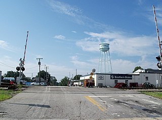
Rich Creek is a town in Giles County, Virginia, United States. The population was 774 as per the 2010 census, up from 665 as per the 2000 census. It is part of the Blacksburg–Christiansburg Metropolitan Statistical Area.
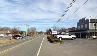
Burkeville is an incorporated town in Nottoway County, Virginia, United States. The population was 432 at the 2010 census. The source of the town name is disputed. The town is located at the crossroads of U.S. routes 360 and 460.
New Creek is an 18.4-mile-long (29.6 km) stream in eastern West Virginia, United States. It is the third major West Virginia tributary to the North Branch Potomac River. Via the Potomac, it is part of the watershed of Chesapeake Bay.
Tearcoat Creek is an 18.3-mile-long (29.5 km) free-flowing tributary stream of the North River, itself a tributary of the Cacapon River, making it a part of the Potomac River and Chesapeake Bay watersheds. The creek is located in central Hampshire County, West Virginia. Its name is believed to have been derived from the tearing of the coats of British soldiers by low-hanging branches as they forded the stream during either the French and Indian or the American Revolutionary Wars.
Tilhance Creek is a 10.4-mile-long (16.7 km) tributary stream of Back Creek in Berkeley County of West Virginia's Eastern Panhandle.
Mill Creek is an 8.7-mile-long (14.0 km) tributary stream of Patterson Creek in Mineral County, West Virginia. It is also known as Mill Run.
Bearwallow Creek is a 4.3-mile-long (6.9 km) tributary stream of Tearcoat Creek, itself a tributary of the North River, making it a part of the Potomac River and Chesapeake Bay watersheds. Bearwallow Creek is located in Hampshire County, West Virginia. It rises on Chestnut Oak Ridge, from which it flows southwest along the ridge's eastern flanks and then begins its course southeast along Bear Wallow Hollow Road and U.S. Route 50 until its confluence with Tearcoat Creek at Pleasant Dale.
Nellysford is a census-designated place (CDP) in Nelson County, Virginia, United States. The population as of the 2010 Census was 1,076. It is home to the Wintergreen golf course at Stoney Creek. Its zip code is 22958.
Buffalo Creek is a 4.1-mile-long (6.6 km) free-flowing tributary stream of the South Branch Potomac River, itself a tributary of the Potomac River, making it a part of the Chesapeake Bay watershed. Buffalo Creek is located in west-central Hampshire County in the U.S. state of West Virginia. Because the stream flows through several small farms, Buffalo Creek primarily serves agriculture purposes with segments used for livestock watering.
Zion Crossroads is an unincorporated community in Louisa and Fluvanna counties of Virginia. It is at the intersections of James Madison Highway and Three Notch Road. Interstate 64 in Virginia passes one-half mile to the northeast.
Allens Creek is an unincorporated community in Nelson County, Virginia, United States.
Old Myndus is an unincorporated community in Nelson County, Virginia, United States.
Buffalo Creek is a 21.1-mile-long (34.0 km) tributary of the Appomattox River in the U.S. state of Virginia. Flowing entirely through Prince Edward County, it joins the Appomattox River at Farmville.
Battle Creek is an unincorporated community in Page County, in the U.S. state of Virginia. It is home to the county landfill, located on U.S. Route 340, which was cleared from the nominally forested area that is common in the locality.

Huguenot Springs is an unincorporated community in Powhatan County, in the U.S. state of Virginia. This community is bordered by Chesterfield County. People live on SR 607 and on other subdivision roads.
Trenholm is an unincorporated community in Powhatan County, in the U.S. state of Virginia. This area includes historic Muddy Creek Baptist Church.
Patterson Creek is a 51.2-mile-long (82.4 km) tributary of the North Branch Potomac River in West Virginia's Eastern Panhandle, in the United States. It enters the North Branch east of Cumberland, Maryland, with its headwaters located in Grant County, West Virginia. Patterson Creek is the watershed for two-thirds of Mineral County, West Virginia. The creek passes through Lahmansville, Forman, Medley, Williamsport, Burlington, Headsville, Reeses Mill, Champwood, and Fort Ashby.
The original Maggoty Gap was a wind gap in the Blue Ridge Mountains in the counties of Roanoke, Virginia and Franklin, Virginia. Over time, as roads were improved and relocated, the identified location of the gap moved with them. It is now mapped at a spot in Roanoke County.
Alum Creek is a stream in the U.S. state of West Virginia. It is a tributary of Tug Fork.
References
- ↑ U.S. Geological Survey Geographic Names Information System: Tear Wallet Creek
- ↑ Wilkerson, Lyn (19 June 2010). Slow Travels-Virginia. Lyn Wilkerson. p. 200. ISBN 978-1-4523-3884-2.
37°28′01″N78°13′52″W / 37.467°N 78.231°W