Related Research Articles

Kiribati consists of 32 atolls and one island in an expanse of ocean equivalent in size to the contiguous United States. The islands are scattered such that Kiribati has territory located in each of the four hemispheres. The islands of Kiribati lie roughly halfway between Hawaii and Australia in the Micronesian and Polynesian regions of the South Pacific. The three main island groupings are the Gilbert Islands, Phoenix Islands, and Line Islands. On 1 January 1995 Kiribati moved the International Date Line to include its easternmost islands and make it the same day throughout the country.

Anote Tong is an I-Kiribati environmental activist and former politician for the Pillars of Truth party with half Chinese heritage, who served as the fourth president of Kiribati, from 2003 to 2016. He won the election in July 2003 with a slim plurality of votes cast (47.4%) against his older brother, Harry Tong (43.5%) and the private lawyer Banuera Berina (9.1%). The elections were contested by the opposition, due to allegations of electoral fraud but the High Court of Tarawa had confirmed that there was no fraud. He was re-elected on 17 October 2007 for a second term (64%). In 2012, Tong was reelected for a third term, although with a significantly smaller percentage than in the previous two elections.

The Ratak Chain is a chain of islands and atolls within the island nation of the Marshall Islands. Ratak means "sunrise". It lies to the east of the country's other island chain, the Ralik Chain. In 1999, the total population of the Ratak islands was 30,925.

UTC+12:00 is an identifier for a time offset from UTC of +12:00.
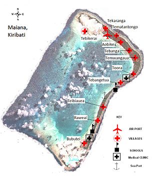
Maiana is an atoll in Kiribati and is one of the Central Gilbert Islands. Maiana is 44 kilometres (27 mi) south of the capital island of South Tarawa and has a population of 1,982 as of 2015. The northern and eastern sides of the atoll are a single island, whilst the western edge consists of submerged reefs and many uninhabited islets, all surrounding a lagoon. The atoll is 14 kilometres (8.7 mi) long and is very narrow, with an average width of less than 1 kilometre (0.62 mi) and a total land area of 16.72 square kilometres (6.46 sq mi).

Bikeman Island is a submerged islet about a half-hour's canoe ride northeast of Betio, Kiribati. Due to changing currents and the construction of a causeway between Betio and Bairiki, Bikeman has been submerged since the early 1990s. If one were to stand on Bikeman today, the water would reach up to one's knees.
Tebiauea is a settlement in Kiribati. It is located on Maiana Atoll; the nearest location, about six nautical miles north, is Tebikerai. There are 147 residents of the village.
Morikao is a village on Abaiang, atoll in Kiribati. There are 233 residents of the village. The nearest villages are Koinawa and Aonobuaka to the north and Taburao is to the south.
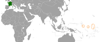
France and Kiribati maintain official diplomatic relations, but no diplomatic presence on each other's territory; the French embassy in Suva is accredited to Kiribati.

The Cabinet of Kiribati is the cabinet of the government of the Republic of Kiribati.
The 2009 Kiribati ferry accident was the sinking, on 13 July 2009, of an inter-island ferry in the south Pacific nation of Kiribati. The accident is believed to have killed 33 of the ship's 55 passengers and crew.
Maiana is a parliamentary constituency electing two representatives to the House of Assembly of Kiribati. It encompasses the atoll of the same name in the Gilbert Islands.
Bonriki is a settlement on Tarawa atoll, Kiribati, near Temwaiku and is part of the municipality of South Tarawa. It is in the south-east of South Tarawa. Bonriki International Airport, one of two international airports in Kiribati, is located here. One of the first roads linking islands together in Tarawa connects Bonriki to Bikenibeu.
Buota is an islet and a settlement on the island of Tarawa, Kiribati. There are 1,756 inhabitants (2015). The islet is the southernmost part of North Tarawa even if there is a bridge connecting it to Bonriki and South Tarawa.
David Collins is an I-Kiribati politician and was the MP of Maiana. He has also represented Kiribati in basketball and football, playing for the latter as a midfielder at the 2003 South Pacific Games.
King George V and Elaine Bernacchi School (KGV/EBS) is a government senior high school of Kiribati, located in Bikenibeu, South Tarawa. As of 1993 it had almost 600 students. In 1993 it had a competitive admissions process as there was not enough space for every high school student in Kiribati; the remainder had to enroll in Christian high schools. Since then the Kiribati government has established two additional government high schools.
Stephen Whitmee High School is a senior high school in Morikao, Abaiang Island, Kiribati. It is affiliated with the Kiribati Uniting Church.
King George V School (KGV) was a government high school for boys in the Gilbert Islands, within the British colony Gilbert and Ellice Islands. Throughout its history it was in multiple locations in South Tarawa and Abemama. It served as a boarding school, and trained people to be government workers and teachers.

Teaoraereke is a town and settlement in South Tarawa of Kiribati.
Temwaiku is a town and settlement in South Tarawa in Kiribati. It is part of a nearly continuous chain of settlements along the islands of South Tarawa, which are linked by causeways, in the same islet of Bonriki.
References
- ↑ "7. Maiana" (PDF). Office of Te Beretitent - Republic of Kiribati Island Report Series. 2012. Retrieved 28 April 2015.
1°00′N173°00′E / 1.000°N 173.000°E
| | This Kiribati location article is a stub. You can help Wikipedia by expanding it. |