Related Research Articles
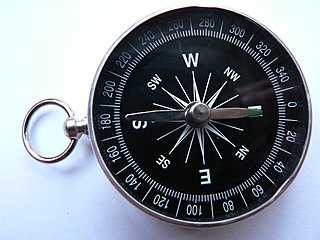
A compass is a device that shows the cardinal directions used for navigation and geographic orientation. It commonly consists of a magnetized needle or other element, such as a compass card or compass rose, which can pivot to align itself with magnetic north. Other methods may be used, including gyroscopes, magnetometers, and GPS receivers.

North is one of the four compass points or cardinal directions. It is the opposite of south and is perpendicular to East and West. North is a noun, adjective, or adverb indicating direction or geography.
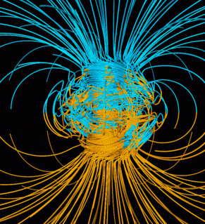
Earth's magnetic field, also known as the geomagnetic field, is the magnetic field that extends from the Earth's interior out into space, where it interacts with the solar wind, a stream of charged particles emanating from the Sun. The magnetic field is generated by electric currents due to the motion of convection currents of a mixture of molten iron and nickel in the Earth's outer core: these convection currents are caused by heat escaping from the core, a natural process called a geodynamo. The magnitude of the Earth's magnetic field at its surface ranges from 25 to 65 μT. As an approximation, it is represented by a field of a magnetic dipole currently tilted at an angle of about 11 degrees with respect to Earth's rotational axis, as if there were an enormous bar magnet placed at that angle through the center of the Earth. The North geomagnetic pole actually represents the South pole of the Earth's magnetic field, and conversely the South geomagnetic pole corresponds to the north pole of Earth's magnetic field. As of 2015, the North geomagnetic pole was located on Ellesmere Island, Nunavut, Canada.

Magnetic declination, or magnetic variation, is the angle on the horizontal plane between magnetic north and true north. This angle varies depending on position on the Earth's surface and changes over time.
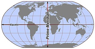
In geography and geodesy, a meridian is the half of an imaginary polar great circle or great ellipse on the Earth's surface, a coordinate line terminated by the North Pole and the South Pole. A meridian is the locus connecting points of equal longitude, which is the angle east or west of a given prime meridian. The position of a point along the meridian is given by that longitude and its latitude, measured in angular degrees north or south of the Equator. Each meridian is perpendicular to all circles of latitude. Meridians are half of a great circle on the Earth's surface. The length of a meridian on a modern ellipsoid model of the earth has been estimated at 20,003.93 km.

Robert Norman was a 16th-century-English mariner, compass builder, and hydrographer who discovered magnetic inclination, the deviation of the Earth's magnetic field from the vertical.
Archaeomagnetic dating is the study and interpretation of the signatures of the Earth's magnetic field at past times recorded in archaeological materials. These paleomagnetic signatures are fixed when ferromagnetic materials such as magnetite cool below the Curie point, freezing the magnetic moment of the material in the direction of the local magnetic field at that time. The direction and magnitude of the magnetic field of the Earth at a particular location varies with time, and can be used to constrain the age of materials. In conjunction with techniques such as radiometric dating, the technique can be used to construct and calibrate the geomagnetic polarity time scale. This is one of the dating methodologies used for sites within the last 10,000 years. The method was conceived by E. Thellier in the 1930s and the increased sensitivity of SQUID magnetometers has greatly promoted its use.
Space physics, also known as solar-terrestrial physics or space-plasma physics, is the study of plasmas as they occur naturally in the Earth's upper atmosphere (aeronomy) and within the Solar System. As such, it encompasses a far-ranging number of topics, such as heliophysics which includes the solar physics of the Sun: the solar wind, planetary magnetospheres and ionospheres, auroras, cosmic rays, and synchrotron radiation. Space physics is a fundamental part of the study of space weather and has important implications in not only to understanding the universe, but also for practical everyday life, including the operations of communications and weather satellites.
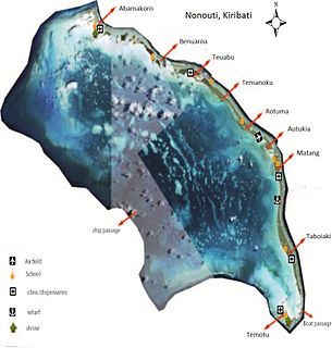
Nonouti is an atoll and district of Kiribati. The atoll is located in the Southern Gilbert Islands, 38 km north of Tabiteuea, and 250 km south of Tarawa. The atoll is the third largest in the Gilbert Islands and is the island where the Roman Catholic religion was first established in Kiribati, in 1888.
Magnetic dip, dip angle, or magnetic inclination is the angle made with the horizontal by the Earth's magnetic field lines. This angle varies at different points on the Earth's surface. Positive values of inclination indicate that the magnetic field of the Earth is pointing downward, into the Earth, at the point of measurement, and negative values indicate that it is pointing upward. The dip angle is in principle the angle made by the needle of a vertically held compass, though in practice ordinary compass needles may be weighted against dip or may be unable to move freely in the correct plane. The value can be measured more reliably with a special instrument typically known as a dip circle.
Makauro is a settlement in Kiribati. It is located on an atoll; to its north are Nanibaba, Tebatabuki, and Temaraia, while Umantewena is to its south.
Umantewena is a settlement on the Nonouti atoll in Kiribati.
Tebatabuki is a settlement in Kiribati. It is located on an atoll; to its north are Nanibaba, Temaraia, Aubeangai, and Tebobonga; Makauro, Tetake, Tenanoraoi, and Umauma are to the south.
Aubeangai is a settlement in Kiribati. It is located on an atoll; to its north are Kaiaroa, Kawantetua, and Tarakarawa; Tebatabuki is to the south, while Nanibaba and Temaraia are to the east.
Rakentai is a settlement in Kiribati. It is located on an atoll; Rotuma and Autukia are to its west, while Kairaoa, Tarakarawa, and Kawantetua are to its south.
Kawantetua is a settlement in Kiribati. It is located on an atoll; Nanibaba, Temaraia, and Autukia are to its west, while Rakentai is to the north and Aubeangai and Tebobonga are to the south.

John Allan Broun FRS was a Scottish scientist with interests in magnetism, particularly of the earth, and meteorology. Broun studied in Edinburgh University and worked at the observatory in Makerstoun from 1842 to 1849 before moving to India to work in the Kingdom of Travancore. He continued his studies on geo-magnetism in India and was involved in setting up observatories there apart from managing the Napier Museum in Trivandrum. One of the fundamental discoveries he made was that the Earth loses or gains magnetic intensity not locally, but as a whole. He also found that solar activity causes magnetic disturbances.

Dahan-e Koklan is a village in Badghis Province in north western Afghanistan.

The north magnetic pole is a point on the surface of Earth's Northern Hemisphere at which the planet's magnetic field points vertically downward. There is only one location where this occurs, near the geographic north pole. The geomagnetic north pole, a related point, is the pole of an ideal dipole model of the Earth's magnetic field that most closely fits the Earth's actual magnetic field.

The history of geomagnetism is concerned with the history of the study of Earth's magnetic field. It encompasses the history of navigation using compasses, studies of the prehistoric magnetic field, and applications to plate tectonics.
References
- ↑ http://www.climate.gov.ki/wp-content/uploads/2013/05/Nonouti-Social-and-Economic-Report-2007-2-of-3.pdf
- ↑ "Magnetic Declination in Tebobonga, Kiribati". What is the Magnetic Declination at your location?. Retrieved Aug 25, 2021.
