
The Calder and Hebble Navigation is a broad inland waterway, with locks and bridge holes that are suitable for 14-foot-wide (4.3 m) boats, in West Yorkshire, England. Construction to improve the River Calder and the River Hebble began in 1759, and the initial scheme, which included 5.7 miles (9.2 km) of new cuts, was completed in 1770 and has remained navigable since it was opened. Significant improvements were made, including the Salterhebble branch to Halifax, opened in 1828, and ever-longer cuts to bypass river sections. Trade was assisted by the opening of the Rochdale Canal in 1804, which provided a through route from Sowerby Bridge to Manchester. There were plans to abandon the river sections completely in the 1830s, but these were modified as the needs of mill owners and other riparian landowners were recognised.
The River Nene is a river that flows through the east of England. At 105 miles (169 km) long, it is the tenth-longest in the United Kingdom.

The River Tees, in England, rises on the eastern slope of Cross Fell in the North Pennines and flows eastwards for 85 miles (137 km) to reach the North Sea in the North East of England. The modern-day history of the river has been tied with the industries on Teesside in its lower reaches, where it has provided the means of import and export of goods to and from the North East England. The need for water further downstream also meant that reservoirs were built in the extreme upper reaches, such as Cow Green.
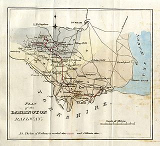
The Stockton and Darlington Railway (S&DR) was a railway company that operated in north-east England from 1825 to 1863. The world's first public railway to use steam locomotives, its first line connected collieries near Shildon with Darlington and Stockton in County Durham, and was officially opened on 27 September 1825. The movement of coal to ships rapidly became a lucrative business, and the line was soon extended to a new port at Middlesbrough. While coal waggons were hauled by steam locomotives from the start, passengers were carried in coaches drawn by horses until carriages hauled by steam locomotives were introduced in 1833.

Stockton-on-Tees is a market town in County Durham, England, with a population of 84,815 at the 2021 UK census. It gives its name to and is the largest settlement in the wider Borough of Stockton-on-Tees. It is part of Teesside and the Tees Valley, on the northern bank of the River Tees.

Middlesbrough is a town in North Yorkshire, England. The town's built-up area, an area spanning from the south bank of the River Tees, up to and including Coulby Newham and Nunthorpe, had a population of 148,215 at the 2021 UK Census. The town's borough is governed by Middlesbrough Council. It is the postal town further south to the North York Moors National Park. The largest town of Teesside and the larger the Tees Valley region, it is the direct regional centre for a population of 678,400 in 2021 and de facto centre for northern Yorkshire and southern County Durham.

Teesside is a built-up area around the River Tees in North East England, split between County Durham and North Yorkshire. The area contains the towns of Middlesbrough, Stockton-on-Tees, Billingham, Redcar, Thornaby-on-Tees, and Ingleby Barwick. Teesside's economy was once dominated by heavy manufacturing until deindustrialisation in the latter half of the 20th century. Chemical production continues to contribute significantly to Teesside's economy.

Thornaby-on-Tees, commonly referred to as Thornaby, is a town and civil parish in the North Yorkshire part of the borough of Stockton-on-Tees, England. The parish had a population of 24,741 at the 2011 census, in the Teesside built-up area. It is located on the south bank of the River Tees.

The Lee Navigation is a canalised river incorporating the River Lea. It flows from Hertford Castle Weir to the River Thames at Bow Creek; its first lock is Hertford Lock and its last Bow Locks.

Bow Creek is a 2.25-mile (3.6 km) long tidal estuary of the English River Lea and is part of the Bow Back Rivers. Below Bow Locks the creek forms the boundary between the London Boroughs of Newham and Tower Hamlets, in East London.
The Grand Junction Canal is a canal in England from Braunston in Northamptonshire to the River Thames at Brentford, with a number of branches. The mainline was built between 1793 and 1805, to improve the route from the Midlands to London, by-passing the upper reaches of the River Thames near Oxford, thus shortening the journey.
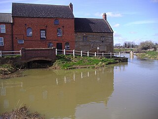
Aislaby is a small village and civil parish on the north bank of the River Tees within the borough of Stockton-on-Tees and the ceremonial county of County Durham, England. It is located to the west of Eaglescliffe and Yarm. The name, first attested as Asulue(s)bi in 1086, is of Viking origin and means "Aslak's farm." Aislaby was listed in the Domesday Book of 1086.

Haverton Hill is an area within the borough of Stockton-on-Tees and ceremonial county of County Durham, England. Once considered a part of Billingham, Haverton Hill was once a thriving industrial community which has suffered significant depopulation since the 1960s as a result of pollution.

Stockton South was a constituency represented in the House of Commons of the UK Parliament from 2019 until its abolition for the 2024 general election by Matt Vickers of the Conservative Party.

Stockton is a railway station on the Durham Coast Line, which runs between Newcastle and Middlesbrough via Hartlepool. The station, situated 5 miles 45 chains (9.0 km) west of Middlesbrough, serves the market town of Stockton-on-Tees in County Durham, England. It is owned by Network Rail and managed by Northern Trains.
The Thames Conservancy was a body responsible for the management of that river in England. It was founded in 1857 to replace the jurisdiction of the City of London up to Staines. Nine years later it took on the whole river from Cricklade in Wiltshire to the sea at Yantlet Creek on the Isle of Grain. Its territory was reduced when the Tideway was transferred to the Port of London Authority in 1909.
The Cleveland Railway was a railway line in north-east England running from Normanby Jetty on the River Tees, near Middlesbrough, via Normanby and then via Guisborough through the Eston Hills, to Loftus in East Cleveland. It carried minerals from numerous iron ore mines along its route to the River Tees for shipment to Tyneside and elsewhere. The line was jointly proposed by the West Hartlepool Harbour and Railway (WHH&R), who provided half its capital, together with various landowners. The WHH&R lay on the north bank of the Tees, to which it had a cross-river connection via a jetty at Normanby.

The Desborough Cut is an artificial channel in the River Thames above Sunbury Lock near Walton on Thames in England. It was completed in 1935, to improve flow and ease navigation on the river.

The Clarence Railway was an early railway company that operated in north-east England between 1833 and 1853. The railway was built to take coal from mines in County Durham to ports on the River Tees and was a competitor to the Stockton and Darlington Railway (S&DR). It suffered financial difficulty soon after it opened because traffic was low and the S&DR charged a high rate for transporting coal to the Clarence, and the company was managed by the Exchequer Loan Commissioners after July 1834. An extension of the Byers Green branch was opened in 1839 by the independent West Durham Railway to serve collieries in Weardale.

