Teixeira, Paraíba

Last updated
Teixeira, Paraíba
Municipality
Bandeira teixeira pb.png
Flag
Brasao teixeira.PNG
Seal
CountryFlag of Brazil.svg  Brazil
Region Northeast
State Paraíba
Mesoregion Sertao Paraibana
Time zone UTC -3

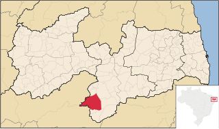
Teixeira, Paraíba is a municipality in the state of Paraíba in the Northeast Region of Brazil. [1] [2] [3] [4]

Municipalities of Brazil administrative division of the states in Brazil

The municipalities of Brazil are administrative divisions of the Brazilian states. At present, Brazil has 5,570 municipalities, making the average municipality population 34,361. The average state in Brazil has 214 municipalities. Roraima is the least subdivided state, with 15 municipalities, while Minas Gerais is the most subdivided state, with 853.

States of Brazil administrative entity of Brazil

The Federative Republic of Brazil is a union of 27 Federative Units : 26 states and one federal district. The states are generally based on historical, conventional borders which have developed over time. The Federal District cannot be divided into municipalities, according to the Brazilian Constitution, the Federal District assumes the same constitutional and legal powers, attributions and obligations of the states and municipalities, instead, it is divided by administrative regions.

Paraíba State of Brazil

Paraíba is a state of Brazil. It is located in the Brazilian Northeast, and it is bordered by Rio Grande do Norte to the north, Ceará to the west, Pernambuco to the south and the Atlantic Ocean to the east. Paraíba is the third most densely populated state of the Northeast; João Pessoa, the sea-bordered state capital, and Campina Grande, in the interior, rank among the fifteen-largest municipalities in the Northeast of Brazil.

See also

Related Research Articles

Vereda, Bahia is a municipality in the state of Bahia in the North-East region of Brazil.

Borborema, Paraíba is a municipality in the state of Paraíba in the Northeast Region of Brazil.

Pilões, Paraíba is a municipality in the state of Paraíba in the Northeast Region of Brazil.

Serraria is a municipality in the state of Paraíba in the Northeast Region of Brazil.

Damião is a municipality in the state of Paraíba in the Northeast Region of Brazil.

Pocinhos, Paraíba Municipality in Northeast, Brazil

Pocinhos, Paraíba is a municipality in the state of Paraíba in the Northeast Region of Brazil.

Itatuba is a municipality in the state of Paraíba in the Northeast Region of Brazil.

Monteiro Municipality in South, Brazil

Monteiro is a municipality in the state of Paraíba in the Northeast Region of Brazil. It is the largest municipality in the state in terms of area.

Ouro Velho, Paraíba is a municipality in the state of Paraíba in the Northeast Region of Brazil.

Jericó, Paraíba Municipality in Northeast, Brazil

Jericó is a municipality in the state of Paraíba in the Northeast Region of Brazil.

Lagoa, Paraíba Municipality in Northeast, Brazil

Lagoa, Paraíba is a municipality in the state of Paraíba in the Northeast Region of Brazil.

Riacho dos Cavalos is a municipality in the state of Paraíba in the Northeast Region of Brazil.

Passagem, Paraíba is a municipality in the state of Paraíba in the Northeast Region of Brazil.

Quixabá, Paraíba is a municipality in the state of Paraíba in the Northeast Region of Brazil.

Santa Teresinha, Paraíba is a municipality in the state of Paraíba in the Northeast Region of Brazil.

Emas, Paraíba is a municipality in the state of Paraíba in the Northeast Region of Brazil.

Santana dos Garrotes is a municipality in the state of Paraíba in the Northeast Region of Brazil.

Juru, Paraíba is a municipality in the state of Paraíba in the Northeast Region of Brazil.

Princesa Isabel Municipality in Northeast, Brazil

Princesa Isabel is a municipality in the state of Paraíba in the Northeast Region of Brazil.

Condado, Paraíba is a municipality in the state of Paraíba in the Northeast Region of Brazil.

References

  1. "Divisão Territorial do Brasil" (in Portuguese). Divisão Territorial do Brasil e Limites Territoriais, Instituto Brasileiro de Geografia e Estatística (IBGE). July 1, 2008. Retrieved December 17, 2009.
  2. "Estimativas da população para 1º de julho de 2009" (PDF) (in Portuguese). Estimativas de População, Instituto Brasileiro de Geografia e Estatística (IBGE). August 14, 2009. Retrieved December 17, 2009.
  3. "Ranking decrescente do IDH-M dos municípios do Brasil" (in Portuguese). Atlas do Desenvolvimento Humano, Programa das Nações Unidas para o Desenvolvimento (PNUD). 2000. Retrieved December 17, 2009.
  4. "Produto Interno Bruto dos Municípios 2002-2005" (PDF) (in Portuguese). Instituto Brasileiro de Geografia e Estatística (IBGE). December 19, 2007. Retrieved December 17, 2009.

Coordinates: 7°13′22″S37°15′14″W / 7.22278°S 37.2539°W / -7.22278; -37.2539

Geographic coordinate system Coordinate system

A geographic coordinate system is a coordinate system that enables every location on Earth to be specified by a set of numbers, letters or symbols. The coordinates are often chosen such that one of the numbers represents a vertical position and two or three of the numbers represent a horizontal position; alternatively, a geographic position may be expressed in a combined three-dimensional Cartesian vector. A common choice of coordinates is latitude, longitude and elevation. To specify a location on a plane requires a map projection.