Telaprolu

Last updated

Telaprolu
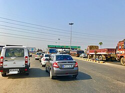
Pottipadu Toll Plaza.jpg
Toll Plaza on AH-45 near Telaprolu
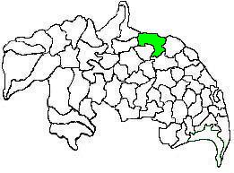
Location map India Andhra Pradesh EN.svg
Red pog.svg
Telaprolu
Location in Andhra Pradesh, India
India location map.svg
Red pog.svg
Telaprolu
Telaprolu (India)
Coordinates: 16°35′10″N80°53′24″E / 16.586°N 80.890°E / 16.586; 80.890 Coordinates: 16°35′10″N80°53′24″E / 16.586°N 80.890°E / 16.586; 80.890
Country India
State Andhra Pradesh
District Krishna
Government
  Body Unguturu Mandal
Area
[1]
  Total25.45 km2 (9.83 sq mi)
Population
(2011) [1]
  Total8,984
  Density350/km2 (910/sq mi)
Languages
  Official Telugu
Time zone UTC+5:30 (IST)
PIN
521109
Telephone code+91–8676
Vehicle registration AP
Lok Sabha Machilipatnam
Assembly constituency Gannavaram

Telaprolu is a village in Krishna district of the Indian state of Andhra Pradesh. It is located in Unguturu mandal of Vijayawada revenue division. [1] It is basically an agricultural village.

Krishna district District of Andhra Pradesh in India

Krishna district is an administrative district in the Coastal Andhra region of the Indian state of Andhra Pradesh. Machilipatnam is the administrative headquarters and Vijayawada is the most populated city in the district. It has an area of 8,727 km2 (3,370 sq mi) and had a population of 45,29,009 as per 2011 census of India. It is bounded by West Godavari on the east, Bay of Bengal on the South, Guntur and Suryapet districts in the west and a portion of it also borders with the state of Telangana. Krishna District is formed from District of Rajahmundry in 1859, Guntur district was separated from Krishna in 1904 to form Krishna district which was further divided in 1925, to Krishna and West Godavari districts.Krishna district is the most developed district in Andhra Pradesh.

India Country in South Asia

India, also known as the Republic of India, is a country in South Asia. It is the seventh largest country by area and with more than 1.3 billion people, it is the second most populous country and the most populous democracy in the world. Bounded by the Indian Ocean on the south, the Arabian Sea on the southwest, and the Bay of Bengal on the southeast, it shares land borders with Pakistan to the west; China, Nepal, and Bhutan to the northeast; and Bangladesh and Myanmar to the east. In the Indian Ocean, India is in the vicinity of Sri Lanka and the Maldives, while its Andaman and Nicobar Islands share a maritime border with Thailand and Indonesia.

Andhra Pradesh State in southern India

Andhra Pradesh is one of the 29 states of India. Situated in the south-east of the country, it is the eighth-largest state in India, covering an area of 162,970 km2 (62,920 sq mi). As per the 2011 census, it is the tenth most populous state, with 49,386,799 inhabitants. The largest city in Andhra Pradesh is Visakhapatnam. Telugu, one of the classical languages of India, is the major and official language of Andhra Pradesh.

Contents

Demographics

Telaprolu village has population of 8984 of which 4274 are males while 4710 are females. Average Sex Ratio of Telaprolu village is 1102 which is higher than Andhra Pradesh state average of 993. Population of children with age 0-6 is 782 which makes up 8.70 % of total population of village. Child Sex Ratio for the Telaprolu as per census is 1036, higher than Andhra Pradesh average of 939. The literacy rate of Telaprolu village was 73.42 % compared to 67.02 % of Andhra Pradesh. [2]


See also

Related Research Articles

Challapalli Village in Andhra Pradesh, India

Challapalli, officially known as Challapalle, is a village in Krishna district of the Indian state of Andhra Pradesh. It is located in Challapalli mandal of Machilipatnam revenue division. Challapalli is one of the villages in the mandal to be a part of Andhra Pradesh Capital Region.

Pathapatnam Place in Andhra Pradesh, India

Pathapatnam is a town in Srikakulam district of the Indian state of Andhra Pradesh. It is located in Pathapatnam mandal of Palakonda revenue division. Pathapatnam is located on the border of Srikakulam district of Andhra Pradesh and Gajapati district of Orissa. Parlakhemundi, the headquarters of Gajapati District, can be considered as twin town of Pathapatnam because of its close proximity. It is located around 65 km from srikakulam.

Puthalapattu mandal in Andhra Pradesh, India

Puthalapattu is a Mandalam in Chittoor district of the Indian state of Andhra Pradesh. It is the mandal headquarters of Puthalapattu mandal. Puthalapattu is suburban of Chittoor city

Rompicherla, Chittoor district Village in Andhra Pradesh, India

Rompicherla is a village in Chittoor district of the Indian state of Andhra Pradesh. It is the mandal headquarters of Rompicherla mandal.

Tadikonda Village in Andhra Pradesh, India

Tadikonda is a village in Tadikonda mandal, located in Guntur district of Andhra Pradesh, India.

Kondapi is a village in Prakasam district of the Indian state of Andhra Pradesh. It is the mandal headquarters of Kondapi mandal in Kandukur revenue division.

Rajupalem, Kadapa district Village in Andhra Pradesh, India

Rajupalem is a village in Kadapa district of the Indian state of Andhra Pradesh. It is located in Rajupalem mandal of Jammalamadugu revenue division. It is located at a distance of 66 km from Kadapa and 25 km from Jammalamadugu.

Chintalapudi, West Godavari district Town in Andhra Pradesh, India

Chintalapudi is a village in West Godavari district of the Indian state of Andhra Pradesh.

Battili Village in Andhra Pradesh, India

Battili is a town in Bhamini mandal of Srikakulam district in Andhra Pradesh, India.

Peda Avutapalli Town in Andhra Pradesh, India

Peda Avutapalli is a developing town in Unguturu mandal, Krishna district, Andhra Pradesh, India. It is located 7.5 km from the Vijayawada Airport. Comes under Gannavaram constituency, Current MLA Dr.Vallabhaneni Vamsi Mohan(TDP).

Badampudi Village in Andhra Pradesh, India

Badampudi is a village in Unguturu mandal, located in West Godavari district of the Indian state of Andhra Pradesh.

Gannavaram mandal Mandal in Andhra Pradesh, India

Gannavaram mandal is one of the 50 mandals in Krishna district of the Indian state of Andhra Pradesh. It is under the administration of Nuzvid revenue division and the headquarters are located at Gannavaram. The mandal is bounded by Agiripalle, Bapulapadu, Unguturu, Vijayawada (rural) and Kankipadu mandals. The mandal is also a part of the Andhra Pradesh Capital Region under the jurisdiction of APCRDA.

Amaravathi mandal, Andhra Pradesh Mandal in Andhra Pradesh, India

Amaravathi mandal is one of the 57 mandals in Guntur district of the Indian state of Andhra Pradesh. It is under the administration of Guntur revenue division and the headquarters are located at Amaravathi. The mandal is located on the banks of Krishna River, at a distance 27 km from the district headquarters. It is bounded by Atchampet, Krosuru, Pedakurapadu, Tadikonda and Thullur mandals.

Budathanapalli Rajeru Village in Andhra Pradesh, India

Budathanapalli Rajeru is a village in Bondapalle mandal in Vizianagaram district of Andhra Pradesh, India. It is familiarly known as B.Rajeru. Budatanapalli Rajeru is surrounded by Gajapathinagaram Mandal to the North, Gantyada Mandal to the South, Mentada Mandal to the North and Gurla Mandal to the East. It is located 20 km North of the district headquarters Vizianagaram.

Unguturu, Guntur district Village in Andhra Pradesh, India

Unguturu is a village in Amaravati Mandal in Guntur district in the Indian state of Andhra Pradesh.

Bestawaripeta is a village in Prakasam district of the Indian state of Andhra Pradesh. It is located in Bestawaripeta mandal of Markapur revenue division.

Chebrolu, West Godavari district Village in Andhra Pradesh, India

Chebrolu is a village in West Godavari district of the Indian state of Andhra Pradesh. It is located in Unguturu mandal of Eluru revenue division.The nearest town is Tadepalligudem.The AH45(Asian Highway)which runs from NH16 in Kolkata to NH48 in Bangalore passes by the village with beautiful Godavari canal on the other side.

Ravipadu, Pedanandipadu mandal village in Andhra Pradesh, India

Ravipadu is a village in Pedanandipadu mandal, Guntur District, Andhra Pradesh, India.

Unguturu mandal, West Godavari district Mandal in Andhra Pradesh, India

Unguturu mandal is one of 46 mandals in the West Godavari district of the Indian state of Andhra Pradesh. The headquarters are located at Unguturu town. The mandal is bordered by Tadepalligudem mandal and Pentapadu mandal to the north, Nallajerla mandal to the west, Nidamarru mandal to the east, and by Dwaraka Tirumala mandal and Bhimadole mandal to the south

Bapulapadu mandal Mandal in Andhra Pradesh, India

Bapulapadu mandal is one of the 50 mandals in Krishna district of the Indian state of Andhra Pradesh. The headquarters of this mandal is located at Bapulapadu town. The mandal is bordered by Nuzvid mandal and Agiripalle mandal to the north, West Godavari district to the east, Nandivada mandal to the south and Unguturu mandal to the west.

References

  1. 1 2 3 "District Census Handbook - Guntur" (PDF). Census of India. p. 16,310. Retrieved 8 January 2016.
  2. "Telaprolu Census 2011".