
With a population of about 129 million in 2022, Mexico is the 10th most populated country in the world. It is the largest Spanish-speaking country in the world and the third-most populous country in the Americas after the United States and Brazil. Throughout most of the 20th century Mexico's population was characterized by rapid growth. Although this tendency has been reversed and average annual population growth over the last five years was less than 1%, the demographic transition is still in progress; Mexico still has a large youth cohort. The most populous city in the country is the capital, Mexico City, with a population of 8.9 million (2016), and its metropolitan area is also the most populated with 20.1 million (2010). Approximately 50% of the population lives in one of the 55 large metropolitan areas in the country. In total, about 78.84% of the population of the country lives in urban areas, and only about 21.16% in rural ones.

Guadalajara is a city in western Mexico and the capital of the state of Jalisco. According to the 2020 census, the city has a population of 1,385,629 people, making it the 7th most populous city in Mexico, while the Guadalajara metropolitan area has a population of 5,268,642 people, making it the third-largest metropolitan area in the country and the twentieth largest metropolitan area in the Americas. Guadalajara has the second-highest population density in Mexico, with over 10,361 people per square kilometer. Within Mexico, Guadalajara is a center of business, arts and culture, technology and tourism; as well as the economic center of the Bajío region. It usually ranks among the 100 most productive and globally competitive cities in the world. It is home to numerous landmarks, including Guadalajara Cathedral, the Teatro Degollado, the Templo Expiatorio, the UNESCO World Heritage site Hospicio Cabañas, and the San Juan de Dios Market—the largest indoor market in Latin America.
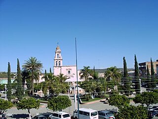
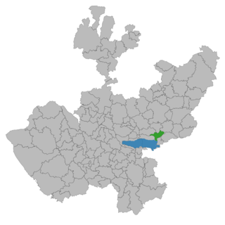
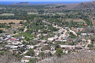
Cocula is a city and municipality in the Mexican state of Jalisco. It is located 35 mi (56 km) southwest of Guadalajara, on Mexico Highway 80. It sits at an elevation of 4,460 feet (1,360 m). According to the 2020 census, the population of the municipality was 29,267 with 16,550 inhabitants living in the city. Other important towns in the municipality are Cofradía de la Luz, La Sauceda, and Santa Teresa.
Ocotlán is a city and municipality in Jalisco, Mexico. Its industry includes furniture production. Is the seat of the Región Ciénega.

Tenamaxtlán is a municipio (municipality) and town in the Sierra de Amula Region in the state of Jalisco, Mexico.
Amatlán de Cañas is a municipality and municipal seat in the southwest of the Mexican state of Nayarit. The population in 2005 was 10,392 in a total area of 765 km², which made up 2.77% of the surface of the state. The municipal seat had a population of 3,275 in 2005.

Arandas is a municipality of the Altos Sur region of the state of Jalisco in Mexico. Arandas is also the name of the municipality's main township and the center of the municipal government. The city centre is located approximately 86 miles (138 km) east of Guadalajara, the state capital. Arandas is accessible to residents of Guadalajara by the Mexican Federal Highway 80D and Jalisco State Highway 314.

The Guadalajara metropolitan area is the most populous metropolitan area of the Mexican state of Jalisco and the third largest in the country after Greater Mexico City and Monterrey. It includes the core municipality of Guadalajara and the surrounding municipalities of Zapopan, Tlaquepaque, Tonalá, Tlajomulco de Zúñiga, El Salto, Ixtlahuacán de los Membrillos and Juanacatlán.
Oaxtepec is a town within the municipality of Yautepec and the Cuautla metropolitan area in the eastern part of the Mexican state of Morelos. Its main industry is tourism, mostly aimed at the inhabitants of nearby Mexico City, and the town possesses various aquatic resorts and hotels. The climate is tropical and the countryside very lush.

Tamasopo is a municipality and town in the Mexican state of San Luis Potosí. The town is located at 21°55′21″N99°23′33″W. The municipality has an area of 1,329 square kilometres (513 sq mi) and a population of 28,848 in 2010, including the population of the town of Tamasopo with 4,326 people.
La Manzanilla is a town located in La Huerta Municipality, Jalisco, Mexico. The village is located in the southeastern corner of the Bay of Tenacatita, on the Costalegre of southwestern mainland Mexico in the state of Jalisco. "Manzanilla" is Spanish for chamomille. The population was 1,592 according to the 2020 census.

Zapotlanejo is a town and municipality in the Mexican state of Jalisco.
Gómez Farías Municipality is situated in the Mexican state of Tamaulipas. The town of Gómez Farías serves as the municipal seat of government. Covering an area of 433 square kilometres, Gómez Farías Municipality had a population of 8,786 as of 2010. The town of Gómez Farías, specifically, had a population of 883 in the same year. Additionally, within the municipal area, a portion of 23,124 hectares is encompassed by the El Cielo Biosphere Reserve.

Calvillo is a municipality in the Mexican state of Aguascalientes. The city of Calvillo, the second largest in the state, serves as the municipal seat. It is located to the western part of the state, at about 52 kilometers of the city of Aguascalientes. It stands at 21°51′N102°43′W in the southwestern corner of the state. It is bounded by Jalisco and Zacatecas. The municipality, which has an area of 931.26 km², reported a population of 54,136 by 2010. The town of Ojocaliente is another significant community in the municipality. Calvillo is one of the richest, most prosperous municipalities in Aguascalientes.

Ameca is a city and municipality, in Jalisco in central-western Mexico. The municipality covers an area of 839.1 km². The city is bisected by the Ameca River which drains to the Pacific Ocean near Puerto Vallarta. It is located approximately 83 km from the state capital and one of Mexico's largest commercial centers, Guadalajara.

Atengo is both a small town and a municipality of the region Sierra de Amula in the Mexican state Jalisco.
The Huaynamota River is a river in western Mexico. It is a tributary of the Río Grande de Santiago in the southern Sierra Madre Occidental.
Emiliano Zapata is located in the Mexican state of Jalisco in the municipality of La Huerta. at 40th Kilometer in the Highway 200 Barra de Navidad - Puerto Vallarta, in the south coast of Jalisco, it belongs to the touristic area called Costalegre. Emiliano Zapata is one of the largest villages in the municipality of La Huerta, geographically and culturally is neighboring Francisco Villa, where there's not physical boundaries between the towns.

General Zaragoza is a municipality and town of the northeastern Mexican state of Nuevo León. It is located in the south-eastern part of the state. The town is at 23°58′25″N99°46′23″W. The municipality has a total area of 508 square miles (1,315 km2) and had a population of 5,942 in 2010. Most of the population lives in the town of Zaragoza. The elevation of Zaragoza is 4,520 feet (1,379 m). Zaragoza is bordered by Aramberri, on the south and east by Hidalgo, Tamaulipas, and on the west by Doctor Arroyo.
Matatlàn is a town in the municipality of Zapotlanejo in the Mexican state of Jalisco.