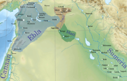
Tell Beydar (also Tall Beydar and Tell Baydar) is an Ancient Near Eastern archaeological site along the Khabur river in the modern Al-Hasakah Governorate, Syria about 30 kilometers north of the modern city of Hasake. It is connected by road to Al-Darbasiyah on the Turkish border in the north. In the mid-third millennium BC it was the city of Nabada which was a provincial center under the city of Nagar (Tell Brak). It is known to have contained 5 large temples (labeled A-E) in the city center (covering 16.5% of the area there) in that period. While it is not known with certainty what deities were worshiped in these temples, the god Šumugan has been suggested as one of them.[1] In recent years domestic construction has been encroaching at the site.[2]
Nabada was first settled during the Early Dynastic I Period circa 2800 BC. By around 2600 BC a medium-sized independent city-state had developed. At that point (c. 2450 BC), it became a provincial capital under the kingdom centered at Nagar, now Tell Brak and reached its maximum size. After the Jezirah region was conquered by the Akkadian empire, Nabada became an minor outpost of that empire. Radiocarbon dates for that transition ranged from 2420 BC to 2270 BC ± 10.[3] The city was then abandoned until re-occupied for a time circa 1400 BC by the Hurrians (Mitanni) and again in the Neo-Assyrian and Hellenistic periods.[4]
Archaeology
Beydar 1
The site was first noted, and photographed, in 1929 by Antoine Poidebard during his aerial survey of the region.[5] The central site of Tell Beydar covers about 22 hectares and has a height of about 27.5 meters above the plain. It has a circular walled central mound (7 hectares) with a circular walled lower town (Beydar I). This is referred to as a Kranzhügel or "cup-and-saucer" tell in archaeology.[6] The inner wall has a diameter of 300 meters and the outer one a diameter of 600 meters. The outer wall was 5 meters thick and had four gates. In the early part of the 3rd millennium BC both sections were occupied but from the middle of the millennium on only the central mound was occupied. A much later 50ha (120-acre) Hurrian and Neo-Assyrian occupation lies at the base of the tell (Beydar II). At the top of the tell there is a Hellenistic settlement. A kilometer to the south there is a small Late Chalcolithic tell (Beydar III).[7] The top of the mound, which has around 20 meters of occupation remains, during the Early Dynastic period held a 50 meter by 60 meter white baked brick palace with 50 rooms with plastered wall and a large central courtyard. This ED IIIb palace used surviving portions of the original 18 room ED II palace.[8] About 20 tombs at the site, some high status, were excavated. Grave goods varied depending on social status and included weapons (in one case a bronze ax), jewelry and pottery.[4]
First Eblaite Empire
Tell Beydar was excavated for 17 seasons, beginning in 1992 and ending in 2010, by a joint Syrian and European team made up of the European Centre for Upper Mesopotamian Studies and the Directorate-General of Antiquities and Museums of Syria.[9][10][11][12][13][14] There were also several restoration seasons. The team leads are Marc Lebeau and Antoine Suleiman.[15][16][17][18][19] In 1997 and 1998 the Oriental Institute of the University of Chicago performed an archaeological survey of the area in a 12 kilometer radius around Tell Beydar. This was later augmented by satellite imagery.[20]University of Venice excavated at the north-eastern slope of the 3rd millennium inner city, just inside the inner town wall at a city gate.[21]
Besides the architectural and pottery findings from the excavation, almost 250 early cuneiform tablets and fragments were recovered, dating from the Early Dynastic III period, roughly a generation before the fall of Ebla. [1] About 220 tablets, found out of context, belong to a single archive.[22] The tablets are agricultural records for the most part, but do establish some synchronisms with Tell Brak. A typical tablet reads "Sheep for plucking: The rams of Lushalim: one hundred; the ewes: one hundred and 85 (L e. 60+20-+5); 3 he-goats: the pastured lambs: 43. Month of the Sun-god.". The language used in the tablets is a variant of the Akkadian language and the personal names referred to were Semitic.[23][24] Small finds include a number of bronze (both tin and arsenical) objects.[25] Over 1500 sealings, representing 215 different designs, were also recovered.[26][27] Finds from Tell Beydar are on display in the Deir ez-Zor Museum.[28]
As a result of the excavation a stratigraphy has been established for the site:[1]
I - Early Dynastic I, Kranzhügel period, 2900-2750 BC
II - Early Dynastic II, area of 22 hectares, 2750-2560 BC
IIIa - Early Dynastic III, lower town abandoned, are reduced to 7 hectares, 2560-2430 BC
IIIb - Early Dynastic III, part of Kingdom of Nagar, 2430-2340 BC
IV - Proto-Imperial, Akkadian Empire, Post Akkad, 2340-2100 BC
123Sallaberger, Walther, and Alexander Pruß, "Home and work in Early Bronze Age Mesopotamia:“ration lists” and “private houses” at Tell Beydar/Nabada" Labor in the ancient world,, pp. 69-136, 2015
↑Mamo, Adnan Rashid, et al., "The impact of the Syrian conflict on archaeological sites in Al-Hasakah province", Journal of Archaeological Science: Reports 43, 103486, 2022
↑Lebeau, M., "Dating the Destructions of Ebla, Mari and Nagar from Radiocarbon with References to Egypt, Combined with Stratigraphy and Historical Data", in H. Baker, K. Kaniuth and A. Otto (eds.), Stories of Long Ago. Festschrift für Michael D. Roaf, Alter Orient und Altes Testament 397, Muster: Ugarit Verlag, pp. 301-323, 2012
12Joachim Bretschneider, "Nabada: The Buried City", Scientific American, vol. 283, pp. 74–81, 2000
↑Ur, Jason A., and Tony J. Wilkinson, "Settlement and economic landscapes of Tell Beydar and its hinterland", Subartu XXI, Brepols, pp. 305-327, 2008
↑Smith, Stefan L., "The View from the Steppe: Using Remote Sensing to Investigate the Landscape of ‘Kranzhügel’ in Its Regional Context", New Agendas in Remote Sensing and Landscape Archaeology in the Near East: Studies in Honour of Tony J. Wilkinson, edited by Dan Lawrence et al., Archaeopress, pp. 109–23, 2020
↑Milano, Lucio, and Elena Rova, "Preliminary report on the 1997 excavations of Ca'Foscari University of Venice at Tell Beydar (Syria)", Mesopotamia 36, pp. 49-87, 2001
↑Weiss, Harvey, "Archaeology in Syria", American Journal of Archaeology, vol. 101, no. 1, pp. 97–148, 1997
↑ Marc Lebeau and Antoine Suleiman, "Report on the 13th Season of Excavations and the 4th Season of Architectural Restoration at Tell Beydar", 2005
↑ Marc Lebeau and Antoine Suleiman, "Report on the 14th Season of Excavations and the 5th Season of Architectural Restoration at Tell Beydar", 2006
↑ Marc Lebeau and Antoine Suleiman, "Report on the 15th Season of Excavations and the 6th Season of Architectural Restoration at Tell Beydar", 2008
↑ Marc Lebeau and Antoine Suleiman, "Report on the 16th Season of Excavations at Tell Beydar ", 2009
↑ Marc Lebeau and Antoine Suleiman, "Report on the 17th Season of Excavations at Tell Beydar", 2010
↑M. Lebeau, A. Suleiman , "Tell Beydar, Three Seasons of Excavations (1992-1994). A Preliminary Report",David Brown, 1997, ISBN2-503-50584-8
↑M. Lebeau and A. Suleiman, "Tell Beydar: The 1995-1999 Seasons of Excavations: a Preliminary Report", Brepols Publishers, 2003, ISBN2-503-99117-3
↑Marc Lebeau, Antoine Suleiman, "Tell Beydar, the 2000-2002 Seasons of Excavations, the 2003-2004 Seasons of Architectural Restoration", Brepols Publishers, 2007, ISBN2-503-51812-5
↑Lebeau, Marc and Suleiman, Antoine (eds.), "Tell Beydar, The 2004/2–2009 Seasons of Excavations, The 2004/2–2009 Seasons of Architectural Restoration. A Preliminary Report", Subartu 29, Turnhout: Brepols, 2011
↑Lebeau, Marc and Suleiman, Antoine (eds.), "Tell Beydar, The 2010 Season of Excavations and Architectural Restoration – A Preliminary Report", Subartu 34, Turnhout: Brepols, 2011
↑Wilkinson, Tony J., and Emma Cunliffe, "The Archaeological Landscape of the Tell Beydar Region: An Update Using Satellite Imagery", The Ancient Near East, a Life! Festschrift Karel Van Lerberghe, pp. 665-679, 2012
↑Milano, Lucio, and Elena Rova, "Five Seasons of Excavations (1997-2001) in Field I at Tell Beydar (Syria)", Asia Anteriore Antica. Journal of Ancient Near Eastern Cultures 2, pp. 169-179, 2020
↑Sallaberger, Walther, "Grain accounts: personnel lists and expenditure documents", F. Ismail, W. Sallaberger, P. talon, and K. van Lerberghe (Eds.), Administrative documents from Tell Beydar (seasons 1993–1995), pp. 81-106, 1996
↑ Marc Lebeau and Antoine Suleiman, "Nabada (Tell Beydar), an Early Bronze Age City in the Syrian Jezirah", 2006
↑ Marc Lebeau and Antoine Suleiman, "Tell Beydar / Nabada - An Early Bronze Age City in the Syrian Jezirah: 10 Years of Research (1992–2002)", 2008
↑De Ryck, I., A. Adriaens, and F. Adams, "Microanalytical metal technology study of ancient near eastern bronzes from Tell Beydar", Archaeometry 45.4, pp. 579-590, 2003
↑G. Jans, J. Bretschneider, "Seals and Sealings from Tell Beydar/Nabada (Seasons 1995 - 2001). A Progress Report", Beydar Monographs, vol. 1, (Subartu XXVII), Brepols, Turnhout, 2012 ISBN978-2-503-53510-4
↑Jans, Greta, and Joachim Bretschneider, "Seals and sealings of Tell Beydar/Nabada", Brepols, 2011 ISBN9782503535104
↑Bonatz, Dominik; Kühne, Hartmut; Mahmoud, As'ad (1998). "Rivers and steppes. Cultural heritage and environment of the Syrian Jezireh. Catalogue to the Museum of Deir ez-Zor". Damascus: Ministry of Culture. OCLC638775287.
Further reading
Peter M. M. G. Akkermans, Glenn M. Schwartz, "The Archaeology of Syria: From Complex Hunter-Gatherers to Early Urban Societies (c.16,000-300 BC)", Cambridge University Press, 2004, ISBN0-521-79666-0
Bonechi, Marco, "Leopards, cauldrons, and a beautiful stone. Notes on some early Syrian texts from Tell Beydar and Ebla", in Semitic and Assyrio- logical Studies Presented to Pelio Fronzaroli, Wiesbaden: Harrassowitz, pp. 75–96, 2003
Bretschneider, Joachim, and Greta Jans, "Checkpoint room 32912: inspection of incoming goods, outgoing wares or temporary disposals in the early Jezireh IIIb official upper city complex of Tell Beydar?", 'L’Heure immobile'Entre ciel et terre: mélanges en l’honneur d’Antoine Souleiman, Vol. 31, Brepols, pp. 9-20, 2012
Bretschneider, Joachim, Anne-Sophie Van Vyve, and G. Jans, "War of the Lords–The Battle of Chronology", Ugarit Forschungen 41, pp. 5-28, 2009
Bretschneider, Joachim, and Karel Van Lerberghe, "Kranzhügel-Städte Und Keilschrift-Archive: Tall Beydar Im Spiegel Der Stadtkulturen Nordmesopotamiens", Antike Welt, vol. 28, no. 4, pp. 289–96, 1997
Broekmans, T., A. Adriaens, and E. Pantos, "Analytical investigations of cooking pottery from Tell Beydar (NE-Syria)", Nuclear Instruments and Methods in Physics Research Section B: Beam Interactions with Materials and Atoms 226.1-2, pp. 92-97, 2004
Rova, Elena, "Seal impressions on pottery in the Khabur Region in the IIIrd millennium BC: some new evidence from Tell Beydar", Baghdader Mitteilungen 37, pp. 295-312, 2006
De Ryck, Ivan, Emmanuel Pantos, and Annemie Adriaens, "Near Eastern ancient bronze objects from Tell Beydar (NE-Syria): Insights into their corrosion", Europhysics news 38.5, pp. 29-33, 2007
Pruß, Alexander, and Walther Sallaberger, "Tierhaltung in Nabada / Tell Beydar Und Die Bilderwelt Der Terrakotten Als Spiegel von Wirtschaft Und Umwelt", Archiv Für Orientforschung, vol. 50, pp. 293–307, 2003
F. Ismail, W. Sallaberger, P. Talon, K. Van Lerberghe, "Administrative Documents from Tell Beydar, Seasons 1993-1995", Brepols Publishers, 1997 ISBN2-503-50539-2
L. Milano, W. Sallaberger, P. Talon, K. Van Lerberghe, "Third Millennium Cuneiform Texts from Tell Beydar, Seasons 1996-2002", Brepols Publishers, 2004, ISBN2-503-51542-8
W. Sallaberger, "Nagar in den frühdynastischen Texten aus Beydar", in K. Van Lerberghe and G. Voet (eds.), Languages and Cultures in Contact. At the Crossroads of Civilizations in the Syro-Mesopotamian Realm. Proceedings of the 42th RAI (Orientalia Lovaniensia Analecta 96; Leuven: Peeters), pp. 393-407, 2000
Siracusano, Giovanni, "Third millennium BC fauna at Tell Beydar", Tell Beydar: Environmental and technical studies II [= Subartu 33], pp. 271-304, 2014
K. Van Lerberghe and G. Voet, "Tell Beydar: Environmental and Technical Studies", Brepols, 2001, ISBN2-503-99121-1
External links
Wikimedia Commons has media related to Tell Beydar.
This page is based on this Wikipedia article Text is available under the CC BY-SA 4.0 license; additional terms may apply. Images, videos and audio are available under their respective licenses.