French Excavations at Tell Kunara, 2300–2000 BC. Sulaymaniyah Governorate, Iraq, 3 October 2019
Tell Kunara is an ancient Near East archaeological site about 10 kilometers southwest of Sulaymaniyah in the Kurdistan region of Iraq. It lies on the Tanjaro River. The site was occupied from the Chalcolithic period to the early second millennium BC.[1]
Clay tablet, freshly excavated, covered with mud to protect it. From Tell Kunara, Sulaymaniyah, Iraq,, 2300–2000 BC. Now in the Sulaymaniyah Museum
The site was occupied in the Akkadian, Ur III, and Isin-Larsa periods. The excavators have speculated that the city, with its monumental buildings, was the capital of the Lullubi state. Initially there were three excavation levels defined (levels 1 and 2 have been radiocarbon dated)
Level 1 – Middle Bronze Age (2000–1900 BC) (in Area C)
Level 2 – End of Early Bronze (2200–2000 BC) (in Areas, B, and E)
Level 3 – Early Bronze Age (2350–2200 BC) (in Areas A and D)
Excavators have now detailed an occupation history for the entire site as[2]
Period I: Medieval or Early Modern Period
Period II: Iron Age
Period III: 2nd millennium BC
Period IV: Late 3rd millennium BC
Period V: Circa 2200-2100 BC
Period VI: Mid 3rd millennium BC
Epigraphic evidence shows the city had an ensi (governor) but under what auspices is unknown at present. A Sukkal (high level dignitary) was also known to be present.[3][4][5]
Archaeology
Akkadian cylinder seal, late third-millennium BC, From Tell Kunara, Tanjro Valley, Sulaymaniyah, Iraq. Sulaymaniyah Museum
Tell Kunara consists of two oval mounds, the western one higher than the eastern, separated by a modern road. The western mound is designated as the Upper Town (excavation area A) and the eastern mound is designated as the Lower Town (excavation areas B, C, D, and E). Overall the site extends to roughly 600 meters by 400 meters or about 10 hectares. The site was first visited in 1943 when Sabri Shukri of the Iraqi General Directorate of Antiquities in Baghdad conducted a survey, issuing a report dated November 10, 1943.[6][7]
The site was examined as part of a larger survey by C. Kepinski in 2011. A geomagnetic survey at Tell Kunara showed signs of a monumental (60 meters by 30 meters) building in the Lower Town[8] It has been excavated in nine seasons since 2012 by a French National Center for Scientific Research team led by Christine Kepinski and Aline Tenu. Since 2012 excavation has mainly focused on the lower town.[9][10] A few 10 centimeter by 10 centimeter cuneiform tablets were found in 2015 in Area C (most concerning flour) and 70 more tablets and fragments in 2017, and another group in 2018 in Area E (most concerning grain) bringing the total to around 100. Volume quantities were listed in a new type of gur (GUR of Šubartu) not previously attested as opposed to the expected Akkadian Empire GUR.[11][12][13][14][6][15] The 2018 season consisted of a study session on the tablets and tablet fragments discovered in 2017.[16] followed by excavations in areas in Areas B, C, and E. Work continued in 2019 with a study mission followed by excavation from September 14 to October 13, in Areas B, C, and E.[17] The latest excavation seasons were in 2022 and 2023.[18][19]
Area A – On the upper mound. A monumental building (1105) was found, with a 2.6 meter wide wall built on a very large stone base foundation. The walls were constructed of "layers of rectangular mud bricks, protected by diluted bitumen and jointed with a mortar containing crushed bones, alternated with about 0.60 m of pisé". The building, which overlays an earlier one with similar plan, was fronted by a 100 square meter courtyard with included a 10-meter terracotta pipe for drainage. The top of the mound had first been sealed and leveled by a several meter thick layer of sand. Small finds included a bronze pendant.[13]
Area B – In the Lower Town, designed to explore the monumental building (Building B.712) identified by the survey. A simple poorly preserved building was found on Level 1. On level 2 lay the monumental building that had appeared on the survey. It had 1.6 meter thick wall footings made out of massive stones with facing stones. Rather than a single building it turned out to be 4 buildings joined together, in an orthogonal layout, by pebbled pathways. The remains of the building on Level 3 had large walls on a completely different orientation. Small finds included bronze pins, beads, molds for casting bronze blades, lithic artifacts, and a finely carved greenish Akkadian period stone cylinder seal.[13]
Area C – A large but shallow excavation at the outer edge of the site. Iron Age pottery shards were found at the surface level and radiocarbon dating of material returned c. 1110−909 BC. To the south, Level 1 remains are fragmentary but appear to be related to food production. Levels 2 and 3 so portions of a monumental building with walls 1.4 meters in width. At the lowest floor were many storage jars. A number of fragmentary cuneiform tablets were found.[6][15]
Area D – several narrow trenches on the slope of the Lower Town to look for a defensive wall and examine the interrelationship with the Upper Town. Small finds here included beads, an obsidian flint, a lithic arrow head of Akkadian type.[6]
Area E - In the northern part of the Lower town. A single occupation level. A monumental building (damaged during the construction of the modern road and other buildings possibly lost) and a small house were found. The monumental building had walls are least 20 meters long, with stone footings. The house was about 36 square meters in area with three rooms. The largest room was about 15 square meters. A number of cuneiform tablets were found in this area.[15]
Excavation photographs
French excavations at Tell Kunara, 2300–2000 BC, Oct. 2015
French excavations at Tell Kunara. 2300–2000 BC, Oct. 2015
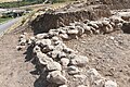
Wall. Excavations at Tell Kunara, 2300–2000 BC
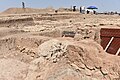
Excavations at Tell Kunara. 2300–2000 BC, October 3 2019
Excavations at Tell Kunara. 2300–2000 BC., October 3 2019
Drainage system. Excavations at Tell Kunara. 2300–2000 BC, October 3 2019
Foundation-walls. Excavations at Tell Kunara. 2300–2000 BC, October 3 2019
French Excavations at Tell Kunara. 2300–2000 BC, October 3 2019
A dagger, a turquoise piece, and a skeleton. Excavations at Tell Kunara, 2300–2000 BC
Excavations at Tell Kunara. 2300–2000 BC, October 3 2019
See also
Wikimedia Commons has media related to Tell Kunara.
↑ Tenu, Aline, and Christine Kepinski. "Kunara, a Bronze Age City on the Upper Tanjaro (Iraq)". 9th International Congress on the Archaeology of the Ancient Near East. Vol. 3, pp. 147–159, 2014
↑ Tenu, Aline, et al., "Rapport préliminaire sur le septième campagne à Kunara (2019)", Studia Mesopotamica, 20, pp. 137-245, 2021
↑ Tenu, Aline, "Kunara, a 4000 year-old city in Kurdistan", 3rd International Scientific Conference under slogan Archaeology and Heritage of Kurdistan held in Erbil, pp. 592–611, 2019
↑ Marchand, Florine, "Kunara Lithic Industry: A Preliminary Report", Proceedings of the 11th International Congress on the Archaeology of the Ancient Near East: Vol. 2: Field Reports. Islamic Archaeology, edited by Adelheid Otto et al., 1st ed., Harrassowitz Verlag, pp. 243–52, 2020
↑ Tenu, Aline, "Excavations at Kunara (Iraqi Kurdistan): New Results", Prehistoric and Historical landscapes & Settlement Patterns, pp. 653–663, 2018
1 2 3 4 Tenu, Aline, et al., "Kunara. Preliminary report on the fifth excavation campaign (2017)", Akkadica, 2019
↑ Kepinski, C., "Research in the Suleymaniyah Province (Iraq): The upper Tanjaro Survey", P. Bieliński et al. (eds.), Proceedings of the 8th International Congress on the Archaeology of the Ancient Near East 30 April – 4 May 2012, University of Warsaw, Volume 2, Wiesbaden, pp. 149–164, 2014
↑ Tenu, Aline, "Kunara: an Early Bronze Age city in the Zagros foothills. The 2018 and 2019 Seasons of Excavations", Proceedings of the 12th International Congress on the Archaeology of the Ancient Near East, vol. 2, Harrassowitz, pp. 603-617, 2023
↑ Tenu, A., Clancier, Ph., Marchand, F., Monerie, J., Sarmiento-Castillo, D., and Verdellet, C., "Kunara. Rapport préliminaire sur la cinquième campagne de fouilles (2017)", Akkadica 140, pp. 5-71, 2019
↑ "Kepinski, C. et al. "Kunara, small town in the foothills of the Zagros Mountains at the age of Bronze: preliminary report on the first campaign of excavations, 2012 (Iraqi Kurdistan)". Akkadica 136.1, 51–88, 2015
↑ Kepinski, Christine, and Aline Tenu. "Two Seasons of Excavations at Kunara (Upper Tanjaro): An Early and Middle Bronze Age City". Archaeological Research in the Kurdistan of Iraq and the Adjacent Areas, Oxford, pp. 139–145, 2016
1 2 3 "Tenu, Aline, et al., "Kunara, a third millennium town in the peaks of Zagros. Preliminary report on the third excavation campaign (2015)", Akkadica, 137.2, pp. 109–182, 2016
↑ Tenu, Aline, et al. "Kunara. Preliminary report on the fourth excavation campaign (2016)". Akkadica 139.1, pp. 1–72, 2018
1 2 3 Tenu, Aline, "The 2016–2017 Excavation Seasons in Kunara (Iraqi Kurdistan)", 11th International Congress on the Archaeology of the Ancient Near East, Apr 2018, Munich Germany, pp. 435-444, 2018
↑ Aline Tenu and Cécile Verdelle, "The 2019 Work in Kunara", CNRX, 2019
↑ Tenu, Aline, "The 2019 Work in Kunara", CNRS, 2023
↑ Tenu, Aline, "The Eighth Excavation Campaign (2022) in Kunara, Iraqi Kurdistan", Proceedings of the 13th International Congress on the Archaeology of the Ancient Near East, Volume 2, pp 359-374, 2015
↑ Barbara Chiti, "The Emergence of Urban Landscapes in Northern Mesopotamia during the 3rd Millennium BCE: New Data from Kunara (Iraqi Kurdistan)", Proceedings of the 13th International Congress on the Archaeology of the Ancient Near East, Volume 1, pp. 107-120, 2025
Further reading
Castillo, David Sarmiento, "Report on area C excavation–Kunara 2016", Dissertation, Mission Archéologique du Peramagron; Direction Générale des Antiquités de Souleymaniyeh, 2016
Kepinski, C. et al. "Kunara, petite ville des piedmonts du Zagros à l'âge du Bronze. Rapport préliminaire sur la première campagne", 2012 (Kurdistan irakien)", Akkadica 136, pp. 51–88, 2015
Kepinski, Christine, and Aline Tenu, "Kunara, ville majeure de la haute vallée du Tanjaro", Routes de l'Orient (2014) Marchand, Florine. "L'industrie Lithique de Kunara". Journée Chainop-Études des chaînes opératoires: Regards croisés sur le site de Kunara (Kurdistan irakien, IIIe millénaire av. J.-C.), 2021
Kepinski, Christine, "Rapport préliminaire sur la première campagne de fouilles à Kunara (Mission Archéologique du Peramagron 2012) niveaux fin Bronze Ancien, début Bronze Moyen", Mesopotamian Studies, 77, 2018
Lafont, Bertrand, "Que se passait-il à Kunara il y a quatre mille ans...?", Parcours d'Orient. Recueil de textes offert à Christine Kepinski, hrsg. v. Bérengère Perello, Aline Tenu, pp. 147-154, 2016
Marchand, Florine, et al., "Kunara Rapport Préliminaire de la septième campagne de fouilles (2019)-Chantier E", Studia Mesopotamica 5, 2021
Perello, Bérengère, Aline Tenu, and Christine Kepinski, "A preliminary assessment on earthen architecture of Iraqi Kurdistan: the case of Kunara (Suleymanieh province) at the end of the 3rd mill. BC", Terra Lyon 2016-XIIe World Congress on Earthen Architecture. 2016
Michaël Seigle, "Kunara (Iraqi Kurdistan), a Town and Its Animal Environment in the 3rd Millennium BCE", in Marchetti, Nicolò, et al. Proceedings of the 12th International Congress on the Archaeology of the Ancient Near East, 06-09 April 2021, Bologna. Vol. 1: Environmental Archaeology. Hammering the Material World. Cognitive Archaeology. Modeling the Past. Networked Archaeology. Endangered Cultural Heritage. Harrassowitz, pp. 161-172, 2023
Tenu, Aline, et al., "Kunara, une ville du IIIe millénaire dans les piémonts du Zagros. Rapport préliminaire sur la troisième campagne de fouilles (2015)", Akkadica 137.2, pp. 109–182, 2016
Tenu, Aline, et al., "Kunara. Rapport préliminaire sur la quatrième campagne de fouilles (2016)", Akkadica 139.1, pp.1–72, 2018
Tenu, Aline, and Philippe Clancier, "The Context of Writing at Kunara (3rd Millennium BCE)", Early Bronze Age in Iraqi Kurdistan, pp. 219-234, 2024
Tenu, Aline, Michaël Seigle, and Cécile Verdellet, "Kunara. Rapport préliminaire sur la sixième campagne de fouilles (2018). Partie 2", Akkadica, 2020.
Tenu A. and Kepinski, Christine, "Prospection dans la haute vallée du Tanjaro. Mission archéologique française du Peramagron 2011", Études Mésopotamiennes – Mesopotamian Studies 1, 2020
Tenu, A., Clancier, Ph., Marchand, F., Monerie, J., Sarmiento-Castillo, D. and Verdellet, C., "Kunara. Rapport préliminaire sur la sixième campagne (2017)", Akkadica 140, pp. 5–71, 2019
Tenu, Aline, et al., "Kunara. Preliminary report on the sixth excavation campaign (2018) Part 1", AKKADICA 141.1, pp. 25-69, 2020
Tenu, Aline, Michael Seigle, and Cecile Verdellet, "Kunara. Preliminary report on the sixth excavation campaign (2018) Part 2", AKKADICA 141.2, pp. 141-191, 2020
Verdellet, Cécile, "Le matériel céramique de Kunara (Kurdistan irakien). Résultats préliminaires", Mesopotamian Studies 522, 2023
This page is based on this Wikipedia article Text is available under the CC BY-SA 4.0 license; additional terms may apply. Images, videos and audio are available under their respective licenses.