Ur was an important Sumerian city-state in ancient Mesopotamia, located at the site of modern Tell el-Muqayyar in Dhi Qar Governorate, southern Iraq. Although Ur was once a coastal city near the mouth of the Euphrates on the Persian Gulf, the coastline has shifted and the city is now well inland, on the south bank of the Euphrates, 16 km (10 mi) from Nasiriyah in modern-day Iraq. The city dates from the Ubaid period c. 3800 BC, and is recorded in written history as a city-state from the 26th century BC, its first recorded king being King Tuttues.

Nippur was an ancient Sumerian city. It was the special seat of the worship of the Sumerian god Enlil, the "Lord Wind", ruler of the cosmos, subject to An alone. Nippur was located in modern Nuffar 5 miles north of modern Afak, Al-Qādisiyyah Governorate, Iraq. It is roughly 200 kilometers south of modern Baghdad and about 96.54 km southeast of the ancient city of Babylon. Occupation at the site extended back to the Ubaid period, the Uruk period, and the Jemdet Nasr period. The origin of the ancient name is unknown but different proposals have been made.
Sippar was an ancient Near Eastern Sumerian and later Babylonian city on the east bank of the Euphrates river. Its tell is located at the site of modern Tell Abu Habbah near Yusufiyah in Iraq's Baghdad Governorate, some 69 km (43 mi) north of Babylon and 30 km (19 mi) southwest of Baghdad. The city's ancient name, Sippar, could also refer to its sister city, Sippar-Amnanum ; a more specific designation for the city here referred to as Sippar was Sippar-Yaḫrurum (Sippar-Jaḫrurum). The name comes from the Amorite Yaḫrurum tribe that lived in the area along with the Amorite Amnanum tribe. In Sippar was the site where the Babylonian Map of the World was found.
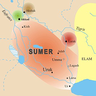
Umma (Sumerian: 𒄑𒆵𒆠 [ummaKI] Error: {{Transliteration}}: transliteration text not Latin script ; in modern Dhi Qar Province in Iraq, was an ancient city in Sumer. There is some scholarly debate about the Sumerian and Akkadian names for this site. Traditionally, Umma was identified with Tell Jokha. More recently it has been suggested that it was located at Umm al-Aqarib, less than 7 km to its northwest or was even the name of both cities. One or both were the leading city of the Early Dynastic kingdom of Gišša, with the most recent excavators putting forth that Umm al-Aqarib was prominent in EDIII but Jokha rose to preeminence later. The town of KI.AN was also nearby. KI.AN, which was destroyed by Rimush, a ruler of the Akkadian Empire. There are known to have been six gods of KI.AN including Gula KI.AN and Sara KI.AN.
Adab was an ancient Sumerian city between Girsu and Nippur, lying about 35 kilometers southeast of the latter. It was located at the site of modern Bismaya or Bismya in the Al-Qādisiyyah Governorate of Iraq. The site was occupied at least as early as the 3rd Millenium BC, through the Early Dynastic, Akkadian Empire, and Ur III empire periods, into the Kassite period in the mid-2nd millennium BC. It is known that there were temples of Ninhursag/Digirmah, Iskur, Asgi, Inanna and Enki at Adab and that the city-god of Adab was Parag'ellilegarra (Panigingarra) "The Sovereign Appointed by Ellil".

Naram-Sin, also transcribed Narām-Sîn or Naram-Suen, was a ruler of the Akkadian Empire, who reigned c. 2254–2218 BC, and was the third successor and grandson of King Sargon of Akkad. Under Naram-Sin the empire reached its maximum extent. He was the first Mesopotamian king known to have claimed divinity for himself, taking the title "God of Akkad", and the first to claim the title "King of the Four Quarters". His military strength was strong as he crushed revolts and expanded the empire to places like Turkey and Iran. He became the patron city god of Akkade as Enlil was in Nippur. His enduring fame resulted in later rulers, Naram-Sin of Eshnunna and Naram-Sin of Assyria as well as Naram-Sin of Uruk, assuming the name.

Shulgi of Ur was the second king of the Third Dynasty of Ur. He reigned for 48 years, from c. 2094 – c. 2046 BC. His accomplishments include the completion of construction of the Great Ziggurat of Ur, begun by his father Ur-Nammu. On his inscriptions, he took the titles "King of Ur", "King of Sumer and Akkad", adding "King of the four corners of the universe" in the second half of his reign. He used the symbol for divinity before his name, marking his apotheosis, from at least the 21st year of his reign and was worshipped in the Ekhursag palace he built. Shulgi was the son of Ur-Nammu king of Ur and his queen consort Watartum.
Amar-Sin, initially misread as Bur-Sin middle chronology, was the third ruler of the Ur III Dynasty. He succeeded his father Shulgi. His name translates to 'bull calf of the moon-god'. The name Amar-Sin was not recorded before his ascension and is a "throne name". His original name, and whether he was actually the son of Shugi, is unknown. It has been proposed that Amar-Sin, Shu-Sin, and Ibbi-Sin were all brothers and sons of Shulgi. Alternatively it has been suggested that Amar-Sin was a nephew of Shulgi, explaining his difficulties at the beginning and ending of his reign.
Der (Sumerian: 𒌷𒂦𒀭𒆠 uruBAD3.ANki; Akkadian: 𒌷𒂦𒀭𒆠 uruBAD3.ANki or 𒌷𒁲𒂊𒊒(𒆠)urude-e-ru(ki)) was a Sumerian city-state at the site of modern Tell Aqar near al-Badra in Iraq's Wasit Governorate. It was east of the Tigris River on the border between Sumer and Elam. At one time it was thought that it might have been ancient Durum (Sumerian: uruBAD3ki) but more recent scholarship has rebutted that.

Zabala, also Zabalam was a city of ancient Sumer in Mesopotamia, located in what is now the Dhi Qar governorate in Iraq. In early archaeology this location was also called Tel el-Buzekh. Locally it is called Tell Bzikh. Zabala was at the crossing of the ancient Iturungal and Ninagina canals, 10 kilometers to the northwest of Umma. The city's deity was Inanna of Zabala. A cuneiform tablet from Zabala contains one of only a few metro-mathematical tables of area measures from the Early Dynastic Period.
Marad was an ancient Near Eastern city. Marad was situated on the west bank of the then western branch of the Upper Euphrates River west of Nippur in modern-day Iraq and roughly 50 km southeast of Kish, on the Arahtu River. The site was identified in 1912 based on a Neo-Babylonian inscription on a truncated cylinder of Nebuchadrezzar noting the restoration of the temple. The cylinder was not excavated but rather found by locals so its provenance was not certain, as to some extent was the site's identification as Marad. In ancient times it was on the canal, Abgal, running between Babylon and Isin.
Tell al-Lahm is an archaeological site in Dhi Qar Governorate (Iraq). It is 38 km (24 mi) southeast of the site of ancient Ur. Its ancient name is not known with certainty with Kuara, Kisig, and Dur-Iakin having been proposed. The Euphrates River is 256 km (159 mi) away but in antiquity, or a branch of it, ran by the site, continuing to flow until the Muslim Era.
Kesh was an ancient Sumerian city and religious site, whose patron goddess was Ninhursag. It was included on the "city seals" found at Jemdat Nasr. These seals sparked the theory at an Early Dynastic Kengir League control Sumer at that time. Its location is uncertain; some of the possible sites put forth include Al-Ubaid, near Ur, or Tell al-Wilayah near Adab or Abu Salabikh or even Tell Jidr though the consensus is now with Tell al-Wilayah or Tulul al-Baqarat. The city is known to be located near to the ancient city of Irisaĝrig and was under the control of that city. According to a riddle from Early Dynastic times, there was a Kesh Canal, which Adab was on.
Tell Uqair is a tell or settlement mound northeast of ancient Babylon, about 25 kilometers north-northeast of the ancient city of Kish, just north of Kutha, and about 50 miles (80 km) south of Baghdad in modern Babil Governorate, Iraq. It was occupied in the Ubaid period and the Uruk period. It has been proposed as the site of the 3rd millennium BC city of Urum.
Sippar-Amnanum, modern Tell ed-Der in Baghdad Governorate, Iraq, was an ancient Near Eastern city about 70 kilometers north of Babylon, 6 kilometers northeast of Sippar and about 26 kilometers southwest of modern Baghdad. Occupation dates back to the days of the Akkadian Empire and later the Ur III period but most of the development was during the Old Babylonian period. Early archaeologists referred to the site as "Der" or Dair". In the late 1800s archaeologists proposed that this was the location of the city of Akkad, later disproved.
Malgium is an ancient Mesopotamian city tentatively identified as Tell Yassir which thrived especially in the Middle Bronze Age, ca. 2000 BC - 1600 BC. Malgium formed a small city-state in an area where the edges of the territories controlled by Larsa, Babylon and Elam converged. Inscribed in cuneiform as ma-al-gi-imKI, its chief deities were Ea and Damkina. A temple of Ulmašītum is known to have been there. There was also a temple to the goddess Bēlet-ilī called Ekitusgestu as well as a temple to the god Anum.

Simurrum was an important city state of the Mesopotamian area from around 2000 BCE to 1500 BCE, during the period of the Akkadian Empire down to Ur III. The Simurrum Kingdom disappears from records after the Old Babylonian period. It has been proposed that in Old Babylonian times its name was Zabban, a notable cult center of Adad. It was neighbor and sometimes ally with the Lullubi kingdom. Zabban is noted as a cult center of Adad into the Neo-Babylonian period.
Puzrish-Dagan is an important archaeological site in Al-Qādisiyyah Governorate (Iraq). It is best-known for the thousands of clay tablets that are known to have come from the site through looting during the early twentieth century.
Tulul al-Baqarat or Tulūl al-Baqarāt, is an ancient Near East archaeological site in Wasit Governorate of Iraq about 180 kilometers southeast of modern Baghdad. It is located seven kilometers to the northeast of Tell al-Wilayah and 20 kilometers south of the city of Kut. The site was occupied from the 4th millennium BC to the Islamic period. It is thought to be the site of the ancient Early Dynastic city of Kesh.
Irisaĝrig was an ancient Near East city in Iraq whose location is not known with certainty but is currently thought to be at the site of Tell al-Wilayah, on the ancient Mama-šarrat canal off the Tigris river, near the ancient site of Kesh, Tulul al-Baqarat. The city was occupied during the Early Dynastic, Akkadian, Ur III, and early Old Babylonian periods. While cuneiform tablets from the city had appeared from time to time, the flood of artifacts entering the private market from looting which followed the 2003 war in Iraq included a large number from Irisaĝrig. This spurred interest by archaeologist in finding the site. The city became of popular interest because of the Hobby Lobby smuggling scandal. While there were a number of significant temples in the city, the titular deity is not known though the Isin-Larsa period literary composition Lament for Eridu names the goddess Aruru in that role. It has also been suggested that there were temples of Ashgi and Alla. There is known to have been a temple of Ninisina and one of Nergal of Eresh in Irisagrig in the Ur III period, at least back to the reign of Shu-Suen and Amar-Sin respectively, and continuing under the rule of Malgium.

