
Newport is both a city and a principal area in Wales, on the River Usk close to its confluence with the Severn Estuary, 12 miles (19 km) northeast of Cardiff. With a population of 145,700 at the 2011 census, Newport is the third-largest city in Wales. Newport became a unitary authority in 1996 and forms part of the Cardiff-Newport metropolitan area with a population of 1,09 million. Newport was the site of the last large-scale armed insurrection in Britain, the Newport Rising of 1839 led by the Chartists. This was led by the Chartist John Frost which led to the re-branding of the Duffryn High School into John Frost School.

Cardiff Bay is the area of water created by the Cardiff Barrage in south Cardiff, the capital of Wales. It is also the name commonly given to the surrounding areas of the city. Cardiff Bay is also used as a metonym for Welsh politics, because it is the location of the Senedd. According to Cardiff Council, the creation of Cardiff Bay is regarded as one of the most successful regeneration projects in the United Kingdom.

Cardiff Central railway station is a major station on the South Wales Main Line, located in the capital of Wales, Cardiff. It is one of the city's two urban rail network hubs, along with Cardiff Queen Street. Opened in 1850 as Cardiff station, it was renamed Cardiff General in 1924, and then Cardiff Central in 1973.

New Barnet is a neighbourhood on the north east side of the London Borough of Barnet. It is a largely residential North London suburb located east of Chipping Barnet, west of Cockfosters, south of the village of Monken Hadley and north of Oakleigh Park.

Llanishen is a district and community in the north of Cardiff, the capital city of Wales. The Cardiff community population taken at the 2011 census was 17,417. Llanishen is well known as the home of the 'Tax Offices', the tallest buildings in north Cardiff and a landmark for miles around. The office complex overlooks the 'Crystal and Fishguard estates', Parc Tŷ Glas industrial estate, old village, leafy suburban roads and various parkland that constitute the district. Llanishen is also home to a fully featured Leisure Centre and the former 60-acre (24 ha) Llanishen Reservoir – a local beauty spot that is connected to a green corridor which bisects the city from the rising hills in the north to Cardiff Bay in the south.

Butetown is a district and community in the south of the city of Cardiff, the capital of Wales. It was originally a model housing estate built in the early 19th century by The 2nd Marquess of Bute, for whose title the area was named. Commonly known as "Tiger Bay", this area became one of the UK's first multicultural communities with people from over 50 countries settled here by the outbreak of the First World War, working in the docks and allied industries. Some of the largest communities included the Somalis, Yemenis and Greeks, whose influence still lives on today. A Greek Orthodox church still stands at the top of Bute Street. It is known as one of the "five towns of Cardiff", the others being Crockherbtown, Grangetown, Newtown and Temperance Town. The population of the ward and community taken at the 2011 census was 10,125.

St Mellons is a district and suburb of southeastern Cardiff, the capital city of Wales. Prior to 1996 St Mellons was the name given to the community largely north of Newport Road (B4487) which included the old St Mellons village. After 1996 the old community was divided and renamed as Old St Mellons and Pontprennau, with the newer, much larger area of modern housing and business parks to the south of Newport Road retaining the St Mellons name. Historically in Monmouthshire, St Mellons became part of South Glamorgan and Cardiff in 1974.

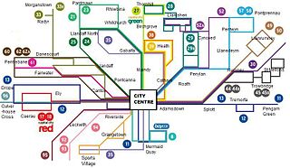
Cardiff city centre is the city centre and central business district of Cardiff, Wales. The area is tightly bound by the River Taff to the west, the Civic Centre to the north and railway lines and two railway stations – Central and Queen Street – to the south and east respectively. Cardiff became a city in 1905.

Kogarah is a suburb of Southern Sydney, in the state of New South Wales, Australia. Kogarah is located 14 kilometres south of the Sydney central business district and is considered to be the centre of the St George area.

Canterbury is a suburb extending across south-western Sydney and the Inner West, in the state of New South Wales, Australia. Canterbury is located 10.5 kilometres (6.5 mi) south-west of the Sydney central business district in the City of Canterbury-Bankstown.

Ely is a district and community in Cardiff, Wales. It is to the north of Cowbridge Road West. Caerau defines the boundary to the south as does River Ely to the east and in part to the north. Ely is primarily dominated by current and former council housing.

Grangetown is a district and community in the south of Cardiff, capital of Wales. It is one of the largest districts in the south of the city and is bordered by Riverside, Canton and Butetown. The River Taff winds its way through the area. Adjacent to the city's Cardiff Bay area, Grangetown is benefitting from the nearby developments and is experiencing a period of gentrification and improvements in its infrastructure. Its population as of 2011 was 19,385 in 8,261 households. One of the "five towns of Cardiff", the others are Butetown, Crockherbtown, Newtown and Temperance Town.

Cardiff Central bus station was the main bus transport interchange in the Cardiff city centre until it closed on 1 August 2015. With 34 stands, it was the largest bus station in Wales. It was located adjacent to Cardiff Central railway station forming a major interchange. Construction of a new bus and transport interchange on the site of the former NCP multi-storey car park in Wood Street, adjacent to the old bus station, is underway with an expected date of completion in Spring 2023.

Architecture in Cardiff, the capital city of Wales, dates from Norman times to the present day. Its urban fabric is largely Victorian and later, reflecting Cardiff's rise to prosperity as a major coal port in the 19th century. No single building style is associated with Cardiff, but the city centre retains several 19th and early 20th century shopping arcades.
Bus transport in Cardiff, the capital and most populous city in Wales, forms the major part of the city's public transport network, which also includes water, air travel and an urban rail network. Cardiff is a major city of the United Kingdom and a centre of employment, retail, business, government, culture, media, sport and higher education.

Newtown was a residential area of Cardiff, Wales that was also known as 'Little Ireland' because of its population of Irish families. Its six streets and 200 houses existed from the mid-nineteenth century until they were demolished in 1970. It was known as one of the "5 towns of Cardiff", the others being Butetown, Crockherbtown, Grangetown and Temperance Town.

Central Square is a large public space in Cardiff, Wales, adjacent to Cardiff Central railway station and including Cardiff bus station between 1954 and 2015. It was redeveloped and extended in the late 2010s.

Wood Street Congregational Church was a congregational chapel which formerly stood on Wood Street, Cardiff. It was once the largest congregational chapel in South Wales. It was demolished in the 1970s.

Cardiff Transport Interchange is a new bus and transport interchange, as well as offices and apartments, in the centre of Cardiff, the capital city of Wales. It has been under construction since 2020 and due for completion in Spring 2023. Once completed it will be run by the Welsh Government's transport arm, Transport for Wales.

