
Salinity is the saltiness or amount of salt dissolved in a body of water, called saline water. It is usually measured in g/L or g/kg.
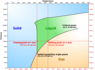
A phase diagram in physical chemistry, engineering, mineralogy, and materials science is a type of chart used to show conditions at which thermodynamically distinct phases occur and coexist at equilibrium.

Thermohaline circulation (THC) is a part of the large-scale ocean circulation that is driven by global density gradients created by surface heat and freshwater fluxes. The adjective thermohaline derives from thermo- referring to temperature and -haline referring to salt content, factors which together determine the density of sea water. Wind-driven surface currents travel polewards from the equatorial Atlantic Ocean, cooling en route, and eventually sinking at high latitudes. This dense water then flows into the ocean basins. While the bulk of it upwells in the Southern Ocean, the oldest waters upwell in the North Pacific. Extensive mixing therefore takes place between the ocean basins, reducing differences between them and making the Earth's oceans a global system. The water in these circuits transport both energy and mass around the globe. As such, the state of the circulation has a large impact on the climate of the Earth.

The surface layer is the layer of a turbulent fluid most affected by interaction with a solid surface or the surface separating a gas and a liquid where the characteristics of the turbulence depend on distance from the interface. Surface layers are characterized by large normal gradients of tangential velocity and large concentration gradients of any substances transported to or from the interface.

An oceanographic water mass is an identifiable body of water with a common formation history which has physical properties distinct from surrounding water. Properties include temperature, salinity, chemical - isotopic ratios, and other physical quantities which are conservative flow tracers. Water mass is also identified by its non-conservative flow tracers such as silicate, nitrate, oxygen, and phosphate.
Psychrometrics is the field of engineering concerned with the physical and thermodynamic properties of gas-vapor mixtures.
In oceanography, a halocline is a cline, a subtype of chemocline caused by a strong, vertical salinity gradient within a body of water. Because salinity affects the density of seawater, it can play a role in its vertical stratification. Increasing salinity by one kg/m3 results in an increase of seawater density of around 0.7 kg/m3.
Spiciness (τ) is a term in oceanography that defines the salinity and potential temperature variation, often at constant density. Here, a temperature change offsets a salinity change; an increase in temperature decreases density whereas an increase in salinity increases density. Warmer and more saline water is spicier whereas cooler and less saline water is mintier.

A pycnocline is the cline or layer where the density gradient is greatest within a body of water. An ocean current is generated by the forces such as breaking waves, temperature and salinity differences, wind, Coriolis effect, and tides caused by the gravitational pull of celestial bodies. In addition, the physical properties in a pycnocline driven by density gradients also affect the flows and vertical profiles in the ocean. These changes can be connected to the transport of heat, salt, and nutrients through the ocean, and the pycnocline diffusion controls upwelling.
Isopycnals are layers within the ocean that are stratified based on their densities and can be shown as a line connecting points of a specific density or potential density on a graph. Isopycnals are often displayed graphically to help visualize "layers" of the water in the ocean or gases in the atmosphere in a similar manner to how contour lines are used in topographic maps to help visualize topography.
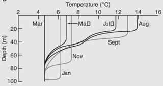
Ocean stratification is the natural separation of an ocean's water into horizontal layers by density, which is generally stable because warm water floats on top of cold water, and heating is mostly from the sun, which reinforces that arrangement. Stratification is reduced by wind-forced mechanical mixing, but reinforced by convection. Stratification occurs in all ocean basins and also in other water bodies. Stratified layers are a barrier to the mixing of water, which impacts the exchange of heat, carbon, oxygen and other nutrients. The surface mixed layer is the uppermost layer in the ocean and is well mixed by mechanical (wind) and thermal (convection) effects. Climate change is causing the upper ocean stratification to increase.
The oceanic or limnological mixed layer is a layer in which active turbulence has homogenized some range of depths. The surface mixed layer is a layer where this turbulence is generated by winds, surface heat fluxes, or processes such as evaporation or sea ice formation which result in an increase in salinity. The atmospheric mixed layer is a zone having nearly constant potential temperature and specific humidity with height. The depth of the atmospheric mixed layer is known as the mixing height. Turbulence typically plays a role in the formation of fluid mixed layers.

A flow tracer is any fluid property used to track flow, magnitude, direction, and circulation patterns. Tracers can be chemical properties, such as radioactive material, or chemical compounds, physical properties, such as density, temperature, salinity, or dyes, and can be natural or artificially induced. Flow tracers are used in many fields, such as physics, hydrology, limnology, oceanography, environmental studies and atmospheric studies.
In atmospheric thermodynamics, the virtual temperature of a moist air parcel is the temperature at which a theoretical dry air parcel would have a total pressure and density equal to the moist parcel of air. The virtual temperature of unsaturated moist air is always greater than the absolute air temperature, however, as the existence of suspended cloud droplets reduces the virtual temperature.
Estuarine water circulation is controlled by the inflow of rivers, the tides, rainfall and evaporation, the wind, and other oceanic events such as an upwelling, an eddy, and storms. Estuarine water circulation patterns are influenced by vertical mixing and stratification, and can affect residence time and exposure time.
In oceanography, a front is a boundary between two distinct water masses. The formation of fronts depends on multiple physical processes and small differences in these lead to a wide range of front types. They can be as narrow as a few hundreds of metres and as wide as several tens of kilometres. While most fronts form and dissipate relatively quickly, some can persist for long periods of time.
Mode water is defined as a particular type of water mass, which is nearly vertically homogeneous. Its vertical homogeneity is caused by the deep vertical convection in winter. The first term to describe this phenomenon is 18° water, which was used by Valentine Worthington to describe the isothermal layer in the northern Sargasso Sea cool to a temperature of about 18 °C each winter. Then Masuzawa introduced the subtropical mode water concept to describe the thick layer of temperature 16–18 °C in the northwestern North Pacific subtropical gyre, on the southern side of the Kuroshio Extension. The terminology mode water was extended to the thick near-surface layer north of the Subantarctic Front by McCartney, who identified and mapped the properties of the Subantarctic mode water (SAMW). After that, McCartney and Talley then applied the term subpolar mode water (SPMW) to the thick near-surface mixed layers in the North Atlantic’s subpolar gyre.
The density ratio of a column of seawater is a measure of the relative contributions of temperature and salinity in determining the density gradient. At a density ratio of 1, temperature and salinity are said to be compensated: their density signatures cancel, leaving a density gradient of zero. The formula for the density ratio, R, is:

Stratification in water is the formation in a body of water of relatively distinct and stable layers by density. It occurs in all water bodies where there is stable density variation with depth. Stratification is a barrier to the vertical mixing of water, which affects the exchange of heat, carbon, oxygen and nutrients. Wind-driven upwelling and downwelling of open water can induce mixing of different layers through the stratification, and force the rise of denser cold, nutrient-rich, or saline water and the sinking of lighter warm or fresher water, respectively. Layers are based on water density: denser water remains below less dense water in stable stratification in the absence of forced mixing.

The Turner angleTu, introduced by Ruddick(1983) and named after J. Stewart Turner, is a parameter used to describe the local stability of an inviscid water column as it undergoes double-diffusive convection. The temperature and salinity attributes, which generally determine the water density, both respond to the water vertical structure. By putting these two variables in orthogonal coordinates, the angle with the axis can indicate the importance of the two in stability. Turner angle is defined as:
