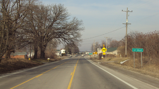
La Salle Township is a civil township of Monroe County in the U.S. state of Michigan. The population was 4,894 at the 2010 census.

St. Thomas, Nevada is a ghost town in Clark County, Nevada, near where the Muddy River flows into the Colorado River. St. Thomas was purchased by the US Federal Government and abandoned as the waters of Lake Mead submerged the town in the 1930s. However, as the level of Lake Mead dropped in the 2000s, the ruins of the town resurfaced. It is now located within the Lake Mead National Recreation Area.
Ten Mile is an unincorporated community in northern Meigs and southeastern Roane counties in the U.S. state of Tennessee.

Las Vegas Bay is a bay at the western edge of Lake Mead in the U.S. state of Nevada. The bay is located within the Lake Mead National Recreation Area to the northeast of the city of Henderson, Nevada, near the junction of Lake Mead Drive and Lake Mead Boulevard. A public campground and boat access are available in Las Vegas Bay. Low water levels of Lake Mead have rendered the marina there inoperable, and it has moved to the Hemenway Boat Harbor, in the south end of the Boulder Basin. The launch ramp there has also been closed due to the water levels.

Cottonwood Cove is situated at the banks of Lake Mohave on the Nevada-Arizona border in Clark County, Nevada, United States. It stands just 13.1 miles and 23 minutes east of Searchlight, 12.5 miles north of Laughlin and an hour away from Las Vegas. It is the site of the Cottonwood Cove Resort and Marina. The cove is part of the Lake Mead National Recreation Area administered by the U.S. National Park Service. The desert lake is approximately 67 miles long and is backed by the Davis Dam on the Colorado River.

Temple Bar Airport is a public use airport in Mohave County, Arizona, United States. It is 1.15 miles southwest of the Temple Bar Marina, located on Lake Mead's Temple Basin. The airport is owned by the U.S. National Park Service.

Lost Lake is a desert community located along the west shore of the Colorado River. It also lies along U.S. Route 95 near the northeast extent of Riverside County. Official U.S. Geological Survey feature ID is 245216 and NAD27 coordinates for the community are 34°00′44″N114°28′27″W. The community lies at the foot of Riverside Mountain, 34°00′49″N114°30′45″W, with a summit measuring 2,127 feet. The community is named for a lake, Lost Lake, located at 34°01′20″N114°28′21″W.

Meadview is an unincorporated community in Mohave County, Arizona, United States, located near Lake Mead. Despite its name, the townsite does not overlook the lake; a ridge to the west of town separates it from the lake. It has 1224 residents in 2010. It was founded in the 1960s as a retirement community.

Bracey is a census-designated place (CDP) in Mecklenburg County, Virginia, United States. It is located next to South Hill, La Crosse, and Broadnax also in Mecklenburg County. The CDP had an estimated population of 1,554 in 2010.
Greggs Hideout lies east of Temple Basin on the Arizona side of Lake Mead. Lake Mead, and all of its points of interest, is managed by the National Park Service and available to the public for recreational purposes.

Kingman Wash is on the Arizona side of Lake Mead near the Hoover Dam. Lake Mead, and all of its points of interest, is managed by the National Park Service and available to the public for recreational purposes.
South Cove is located on the Arizona side of Lake Mead between Temple Bar and Pierce Ferry. Lake Mead, and all of its points of interest, is managed by the National Park Service and available to the public for recreational purposes.
Temple Bar is on the Arizona side of Lake Mead between Bonelli Landing and Greggs Hideout. Lake Mead, and all of its points of interest, is managed by the National Park Service and available to the public for recreational purposes.
The Virgin Valley is a valley in northwest Arizona and southeast Nevada on the Virgin River. The Virgin River drains southwest Utah and southeast Nevada; parts of Arizona, especially the Arizona Strip region drain southwards into the Virgin River and Valley.

Callville Bay is a waterway on the northwestern side of Lake Mead in the U.S. state of Nevada. It features a marina and camping resort. Situated east of Las Vegas and upstream from Las Vegas Bay, it lies within the Lake Mead National Recreation Area, which was established in 1935. Its name derives from the settlement of Callville which was established in 1865 by Anson Call under a directive led by Brigham Young. Though the settlement was abandoned in 1869, and submerged under Lake Mead when the Colorado River was dammed, Callville Bay retained the name.
Boulder Canyon, originally Devils Gate Canyon, is a canyon on the Colorado River, above Hoover Dam, now flooded by Lake Mead. It lies between Clark County, Nevada and Mohave County, Arizona. It heads at western end of the Virgin River Basin of Lake Mead, at about 36°09′05″N114°32′51″W. Boulder Canyon divides the Black Mountains into the Black Mountains of Arizona, and the Black Mountains of Nevada. Its mouth is now under the eastern end of the Boulder Basin of Lake Mead, between Canyon Point in Nevada and Canyon Ridge in Arizona. Its original mouth is now underneath Lake Mead between Beacon Rock and Fortification Ridge on the southern shore in Arizona.

Echo Bay is an unincorporated community in the U.S. state of Nevada. It is located on the western shore of the Overton Arm of Lake Mead, within Lake Mead National Recreation Area. The community contains a campground run by the National Park Service and a boat ramp. There used to be a marina there as well, but it closed in February 2013. Approximately 200,000 people visit Echo Bay annually. There was a small trailer park for housing.
Boulder Basin is the westernmost of the three basins occupied by the Lake Mead reservoir and lies within the boundaries of Clark County, Nevada and Mohave County, Arizona. It includes the area between Hoover Dam and the mouth of Boulder Canyon at Auxiliary Point. When the reservoir is full it reaches an elevation of 1,204 feet / 367 meters. It includes Las Vegas Bay, Swallow Bay, Callville Bay and Hamblin Bay.


