
Oxfordshire is a landlocked county in South East England. The ceremonial county borders Warwickshire to the north-west, Northamptonshire to the north-east, Buckinghamshire to the east, Berkshire to the south, Wiltshire to the south-west and Gloucestershire to the west.
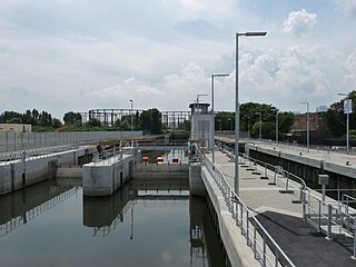
Bow Back Rivers or Stratford Back Rivers is a complex of waterways between Bow and Stratford in east London, England, which connect the River Lea to the River Thames. Starting in the twelfth century, works were carried out to drain Stratford Marshes and several of the waterways were constructed to power watermills. Bow Creek provided the final outfall to the Thames, and the other channels were called Abbey Creek, Channelsea River, City Mill River, Prescott Channel, Pudding Mill River, Saint Thomas Creek, Three Mills Back River, Three Mills Wall River and Waterworks River.
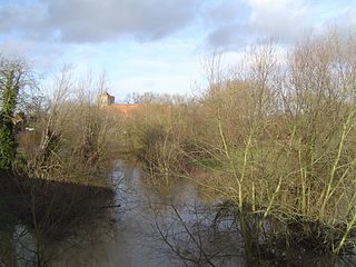
The River Thame is a river in Southern England. It is a tributary of the River Thames.

The Lower Lea Valley is the southern end of the Lea Valley which surrounds the River Lea. It is part of the Thames Gateway redevelopment area and was the location of the 2012 Summer Olympics.

The River Ember is a short river in the north of Surrey, England — a channel of the River Mole which splits in two south of Island Barn Reservoir, between East Molesey and Lower Green, Esher. The Ember, the larger channel, flows in an easterly and then northerly direction around the reservoir, past part of Esher; the Mole flows around the other side past West Molesey. The two rivers then flow side by side approximately north east and merge 400 metres before joining the River Thames at the eastern end of East Molesey opposite Hampton Court Palace on the south side of the last non-tidal reach, which is above Teddington Lock.

The River Neckinger is a reduced subterranean river that rises in Southwark and flows approximately 2.5 kilometres through that part of London to St Saviour's Dock where it enters the Thames. What remains of the river is enclosed and runs underground and most of its narrow catchment has been diverted into other combined and surface water sewers, flowing into the Southern Outfall Sewer and the Thames respectively.
Trowlock Island is a residential island in the River Thames 450 metres (490 yd) upstream of Teddington Lock on the non-tidal Kingston reach less than 10 metres from the northern bank, in the London Borough of Richmond upon Thames, England.

The Thames Path is a National Trail following the River Thames from its source near Kemble in Gloucestershire to the Thames Barrier at Charlton, south east London. It is about 184 miles (296 km) long. A path was first proposed in 1948 but it only opened in 1996.

Temple Island is an eyot in the River Thames in England just north (downstream) of Henley-on-Thames, Oxfordshire. The island is on the reach above Hambleden Lock between the Buckinghamshire and Berkshire banks, and is part of Remenham in Berkshire. The main significance of the island is that it lies at the start of the course for Henley Royal Regatta.

The Duke of Northumberland's River or D. O. N. River consists of separate upper and lower artificial watercourses in west London, United Kingdom. The older name Isleworth Mill Stream/River more accurately describes the economic motivation behind its construction. The first section draws water via a sluice from the Colne — a source river which has seven distributaries, many of which are man-made — today an extended distance of about 5 miles (8 km) into the Crane; its lower section of about 1.8 miles (2.9 km) draws water from that small river in Whitton, Twickenham and discharges it via neighbouring Isleworth, passing Mill Plat into the tidal Thames. A sluice underneath Mill Plat feeds the main lake in Syon Park.

The Mill at Sonning is a theatre and restaurant, converted from an 18th-century flour mill, on an island in the River Thames at Sonning Eye in the English county of Berkshire

The River Alre is a tributary of the River Itchen in Hampshire in the south of England. It rises in Bishop's Sutton and flows west for 6 km (3.7 mi) to meet the Itchen below New Alresford.

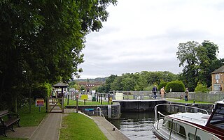
Hambleden Lock is a lock with a long weir situated on the River Thames in England. The lock is on the Berkshire bank between Aston and Remenham. Built by the Thames Navigation Commission in 1773, the lock is named after the village of Hambleden, a mile (1.5 km) to the north.
A tour thro' the whole island of Great Britain is an account of his travels by English author Daniel Defoe, first published in three volumes between 1724 and 1727. Other than Robinson Crusoe, Tour was Defoe's most popular and financially successful work during the eighteenth century. Pat Rogers notes that in Defoe’s use of the “literary vehicle that could straddle the literal and the imaginative,” “Nothing...anticipated Defoe’s Tour”. Thanks in part to his extensive travels and colourful background as a soldier, businessman, and spy, Defoe had “hit on the best blend of objective fact and personal commentary” in his descriptions of locations and trips around Britain.

Temple Mills is a district located on the boundary of the London boroughs of Newham and Waltham Forest, with a small part also in Hackney in east London.

Chiswick Eyot is a 3.266-acre (1.3 ha) narrow, uninhabited ait in the River Thames. It is a tree- and reed-covered rise on the Tideway by Chiswick, in the Borough of Hounslow, London, England and is overlooked by St Nicholas Church, Chiswick, the Mall of Hammersmith and by some of the Barnes riverside on the far bank. Excluding tidal mudflats and sandbanks, it is the most downstream island purely on the Thames itself.

Benson Lock is a lock on the River Thames in England, close to Benson, Oxfordshire but on the opposite bank of the river. The first pound lock here was built by the Thames Navigation Commission in 1788 and it was replaced by the present masonry lock in 1870. The distance between Benson Lock and Cleeve Lock downstream is 6.5 miles (10.4 km) - the longest distance between locks on the River Thames.
Temple Lock is a lock and weir situated on the Buckinghamshire bank of the River Thames near Temple Mill Island opposite Temple Meadows and not far from Hurley, Berkshire. It was first built by the Thames Navigation Commissioners in 1773.

Temple Footbridge is a pedestrian only bridge near Hurley, Berkshire across the River Thames in England. It connects the Buckinghamshire and Berkshire banks. It crosses the Thames just above Temple Lock.

The Green Man is a pub and road junction on High Road, Leytonstone, London. The pub has been rebranded as part of the O'Neill's chain. The current 1920s building replaced an earlier public house on the same site, built around 1668; it was mentioned by Daniel Defoe.
