
A sextant is a doubly reflecting navigation instrument that measures the angular distance between two visible objects. The primary use of a sextant is to measure the angle between an astronomical object and the horizon for the purposes of celestial navigation.

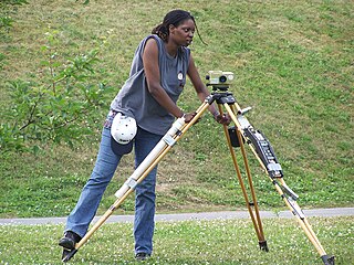
Surveying or land surveying is the technique, profession, art, and science of determining the terrestrial or three-dimensional positions of points and the distances and angles between them. A land surveying professional is called a land surveyor. These points are usually on the surface of the Earth, and they are often used to establish maps and boundaries for ownership, locations, such as the designed positions of structural components for construction or the surface location of subsurface features, or other purposes required by government or civil law, such as property sales.

Binoculars or field glasses are two telescopes mounted side-by-side and aligned to point in the same direction, allowing the viewer to use both eyes when viewing distant objects. Most are sized to be held using both hands, although sizes vary widely from opera glasses to large pedestal mounted military models.

Astrophotography, also known as astronomical imaging, is photography of astronomical objects, celestial events, and areas of the night sky. The first photograph of an astronomical object was taken in 1840, but it was not until the late 19th century that advances in technology allowed for detailed stellar photography. Besides being able to record the details of extended objects such as the Moon, Sun, and planets, astrophotography has the ability to image objects invisible to the human eye such as dim stars, nebulae, and galaxies. This is done by long time exposure since both film and digital cameras can accumulate and sum light photons over these long periods of time.

A tripod is a portable three-legged frame or stand, used as a platform for supporting the weight and maintaining the stability of some other object. A tripod provides stability against downward forces and horizontal forces and movements about horizontal axes. The positioning of the three legs away from the vertical centre allows the tripod better leverage for resisting lateral forces.

A theodolite is a precision optical instrument for measuring angles between designated visible points in the horizontal and vertical planes. The traditional use has been for land surveying, but they are also used extensively for building and infrastructure construction, and some specialized applications such as meteorology and rocket launching.

A spirit level, bubble level, or simply a level, is an instrument designed to indicate whether a surface is horizontal (level) or vertical (plumb). Different types of spirit levels may be used by carpenters, stonemasons, bricklayers, other building trades workers, surveyors, millwrights and other metalworkers, and in some photographic or videographic work.

An eyepiece, or ocular lens, is a type of lens that is attached to a variety of optical devices such as telescopes and microscopes. It is so named because it is usually the lens that is closest to the eye when someone looks through the device. The objective lens or mirror collects light and brings it to focus creating an image. The eyepiece is placed near the focal point of the objective to magnify this image. The amount of magnification depends on the focal length of the eyepiece.
Levelling or leveling is a branch of surveying, the object of which is to establish or verify or measure the height of specified points relative to a datum. It is widely used in geodesy and cartography to measure geodetic height, and in construction to measure height differences of construction artifacts. It is also known as spirit levelling and differential levelling.

A nephoscope was an instrument for measuring the altitude, direction, and velocity of clouds in the 19th century. A ray of light of known velocity is emitted from a nephoscope, which strikes the base of a targeted cloud. The travel time of the return signal is used to estimate the distance to the cloud.

The Ramsden surveying instruments are those constructed by Jesse Ramsden and used in high precision geodetic surveys carried out in the period 1784 to 1853. This includes the five great theodolites—great in name, great in size and great in accuracy—used in surveys of Britain and other parts of the world. Ramsden also provided the equipment used in the measurement of the many base lines of these surveys and also the zenith telescope used in latitude determinations.
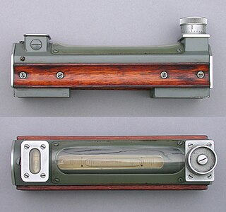
An engineer's spirit level is generally used to level machines, although they may also be used to level large workpieces on machines such as planers. Using gravity as a reference and checking a machine's axis of travel at several points, the level is used to ensure the machine's axis is straight. A perfectly level machine does not actually need to be achieved, unless the particular manufacturing process requires it. Spirit levels are also used in building construction by carpenters and masons.

A tribrach is an attachment plate used to attach a surveying instrument, for example a theodolite, total station, GNSS antenna or target to a tripod. A tribrach allows the survey instrument to be repeatedly placed in the same position over a surveying marker point with sub-millimetre precision, by loosening and re-tightening a lock to adjust the instrument base in a horizontal plane.

A level is an optical instrument used to establish or verify points in the same horizontal plane in a process known as levelling, and is used in conjunction with a levelling staff to establish the relative heights levels of objects or marks. It is widely used in surveying and construction to measure height differences and to transfer, measure, and set heights of known objects or marks.

The meridian circle is an instrument for timing of the passage of stars across the local meridian, an event known as a culmination, while at the same time measuring their angular distance from the nadir. These are special purpose telescopes mounted so as to allow pointing only in the meridian, the great circle through the north point of the horizon, the north celestial pole, the zenith, the south point of the horizon, the south celestial pole, and the nadir. Meridian telescopes rely on the rotation of the sky to bring objects into their field of view and are mounted on a fixed, horizontal, east–west axis.
Tacheometry is a system of rapid surveying, by which the horizontal and vertical positions of points on the earth's surface relative to one another are determined without using a chain or tape, or a separate levelling instrument. Instead of the pole formerly employed to mark a point, a staff similar to a level staff is used. This is marked with heights from the base or foot, and is graduated according to the form of tacheometer in use.

A bull's eye level is a type of spirit level that allows for the leveling of planes in two dimensions — both the 'pitch' and 'roll' in nautical terms. Standard tubular levels only consider one dimension. Bull's eye levels are used primarily by carpenters in construction, but can also be found as features of compasses or other devices that need to be kept from tipping in certain directions. Small bull's eye levels are also found incorporated into tripods.
Polar alignment is the act of aligning the rotational axis of a telescope's equatorial mount or a sundial's gnomon with a celestial pole to parallel Earth's axis.
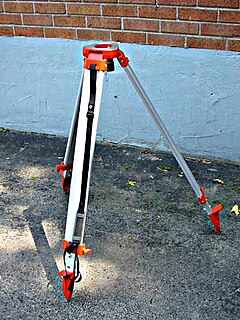
A surveyor's tripod is a device used to support any one of a number of surveying instruments, such as theodolites, total stations, levels or transits.
The permanent adjustments of theodolites are made to establish fixed relationship between the instrument's fundamental lines. The fundamental lines or axis of a transit theodolite include the following:-


