
Ten Mile Lake in Nova Scotia
Ten Mile Lake is a rural community of the Halifax Regional Municipality in the Canadian province of Nova Scotia.
Coordinates: 45°8′31.2″N62°42′43.1″W / 45.142000°N 62.711972°W
Ten Mile Lake is a rural community of the Halifax Regional Municipality in the Canadian province of Nova Scotia.
Coordinates: 45°8′31.2″N62°42′43.1″W / 45.142000°N 62.711972°W

Hudson Strait links the Atlantic Ocean and Labrador Sea to Hudson Bay in Canada. This strait lies between Baffin Island and Nunavik, with its eastern entrance marked by Cape Chidley in Newfoundland and Labrador and Resolution Island off Baffin Island. The strait is about 750 km long with an average width of 125 km, varying from 70 km at the eastern entrance to 240 km at Deception Bay.

The Arctic Archipelago, also known as the Canadian Arctic Archipelago, is an archipelago lying to the north of the Canadian continental mainland, excluding Greenland.
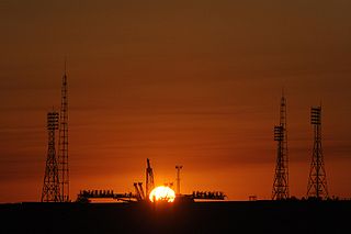
The Baikonur Cosmodrome is a spaceport in an area of southern Kazakhstan leased to Russia. The Cosmodrome is the world's first spaceport for orbital and human launches and the largest operational space launch facility. All crewed Russian spaceflights are launched from Baikonur.

The Halifax Regional Municipality has a number of parks and recreation areas in urban and rural settings.
Northumberland Provincial Park is a provincial park in Prince Edward Island, Canada. It overlooks the Northumberland strait.
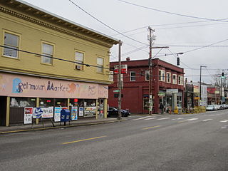
The Belmont Area is a retail and residential district running along SE Belmont St. in the inner Southeast section of Portland, Oregon in a parallel fashion to the Hawthorne District, 6 blocks to the south. From west to east the area extends 48 blocks, from SE 12th Ave. to SE 60th Ave., passing through the Buckman, Sunnyside, and Mount Tabor neighborhoods. The area is seven blocks wide, running from SE Belmont St. 4 blocks north to SE Stark St. and 3 blocks south to SE Salmon St. SE Belmont St. between SE 33rd Ave. and SE 35th Ave., in Sunnyside, is the heart of the district.
Shabica Glacier is a northern tributary glacier to the Clifford Glacier, joining it near its terminus just east of Mount Tenniel, in Palmer Land. Mapped by United States Geological Survey (USGS) in 1974. Named by Advisory Committee on Antarctic Names (US-ACAN) for Stephen V. Shabica, United States Antarctic Research Program (USARP) biologist and Station Scientific Leader at Palmer Station in 1970.

Ice Gate Glacier is a narrow hanging glacier, tributary to Astudillo Glacier, between rock spurs on the west slope of Dallmeyer Peak, Danco Coast, Antarctica. It was named by the Polish Antarctic Expedition in about 1992, probably from the gatelike appearance of the spurs at the junction of the two glaciers.
Wiswell Inlet is a body of water in Nunavut's Qikiqtaaluk Region. It lies in eastern Frobisher Bay, forming a wedge into Baffin Island's Blunt Peninsula. There are several islands at the mouth of the inlet.
Bond Inlet is a body of water in Nunavut's Qikiqtaaluk Region in Canada. It lies in western Hudson Strait, forming a wedge into Baffin Island's Meta Incognita Peninsula and the western slopes of the Everett Mountains.

Mugalkhod is a village in the northern state of Karnataka, India. It is located in the Raybag taluk of Belgaum district in Karnataka.
Long Lake could mean the following :
There are many lakes named Rocky Lake in Nova Scotia, Canada.

The North Shore is a region of Nova Scotia, Canada. Although it has no formal identity and is variously defined by geographic, county and other political boundaries, it is defined by Statistics Canada as an economic region, composed of Antigonish County, Colchester County, Cumberland County, Guysborough County, and Pictou County.

Arisaig Provincial Park is a provincial park located in Antigonish, Nova Scotia, Canada.

Baktriana Reef is the 360 m long in east-west direction and 40 m wide flat and rocky low-tide elevation off the west coast of Snow Island in the South Shetland Islands, Antarctica. Its surface area is 0.33 ha. The vicinity was visited by early 19th century sealers.
| | This Halifax County, Nova Scotia location article is a stub. You can help Wikipedia by expanding it. |