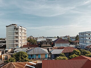
Tengeru is a market-town[1] in the Arusha Region of northern Tanzania. Located below Mount Meru on the eastern edge of the eastern branch of the Great Rift Valley, surrounding Lake Duluti, Tengeru has a temperate climate. The town is thirteen kilometres east of the city of Arusha.[2]
In 1934, Kenyon Painter, an American investor, established a coffee research station at Tengeru,[3] which today is operated by the Lyamungu Research Institute of the Tanzania Ministry of Agriculture and known as the National Centre for Coffee Research.[4]
Plaque at the Cemetery of Polish War Refugees
Beginning in 1942 and continuing after World War II, a camp for displaced persons from central and eastern Europe was established at Tengeru[pl], just south of Lake Duluti. It primarily housed Poles, who were then resettled mainly to Britain, but partly also to the United States, Australia, and other countries.[5] At its height it housed over 4,000 people, but now all that remains of the camp is its large cemetery.[1][6][7][8][self-published source] The dairy and beef cattle farm that was run by the internees was taken over in 1952 by the Ministry of Agriculture and became the Tengeru Horticultural Research and Training Institute (HORTI).[9]
↑ Taylor, Lynne (2009). Polish Orphans of Tengeru: The Dramatic Story of Their Long Journey to Canada, 1941-49. Toronto: Dundurn. ISBN978-1-55488-004-1.
↑ Szostak, Henryk (2013). "Tengeru East Africa". American by Choice. Xlibris. pp.89–145. ISBN978-1-4836-6589-4.
Tanzania, officially the United Republic of Tanzania, is a country in East Africa within the African Great Lakes region. It borders Uganda to the north; Kenya to the northeast; the Indian Ocean to the east; Mozambique and Malawi to the south; Zambia to the southwest; and Rwanda, Burundi, and the Democratic Republic of the Congo to the west. Mount Kilimanjaro, Africa's highest mountain, is in northeastern Tanzania. According to the 2022 national census, Tanzania has a population of nearly 62 million, making it the most populous country located entirely south of the equator.
Transport in Tanzania includes road, rail, air and maritime networks. The road network is 86,472 kilometres (53,731 mi) long, of which 12,786 kilometres (7,945 mi) is classified as trunk road and 21,105 kilometres (13,114 mi) as regional road. The rail network consists of 3,682 kilometres (2,288 mi) of track. Commuter rail service is in Dar es Salaam only. There are 28 airports, with Julius Nyerere International being the largest and the busiest. Ferries connect Mainland Tanzania with the islands of Zanzibar. Several other ferries are active on the countries' rivers and lakes.
Arusha City is a Tanzanian city, with a population of 617,631, and the regional capital of the Arusha Region, with a population of 2,356,255.
Tanga is a historic city and the capital of Tanga Region. The city is the most northernly port city of Tanzania to the west of the Indian Ocean on Tanga Bay. The city has a population of 393,429 in 2022. Tanga is governed by the Tanga City Council. The city is also home to the Port of Tanga. The name Tanga means "sail" in Swahili. The city is also the capital of Tanga District.
Moshi is a municipality and the capital of Kilimanjaro region in the north eastern Tanzania. As of 2017, the municipality has an estimated population of 201,150 and a population density of 3,409 persons per km2. In the last official census of 2022, the municipality had a population of 221,733. The municipality is situated on the lower slopes of Mount Kilimanjaro, a dormant volcano that is the highest mountain in Africa. The name Moshi has been reported to refer to the smoke that emanates from the nearby mountain. The municipality covers about 59 square kilometres (23 sq mi) and is the smallest municipality in Tanzania by area.
The Chagga are a Bantu ethnic group from Kilimanjaro Region of Tanzania. They are the third-largest ethnic group in Tanzania. They historically lived in sovereign Chagga states on the slopes of Mount Kilimanjaro in both Kilimanjaro Region and eastern Arusha Region.
Jakaya Mrisho Kikwete is a Tanzanian politician who was the fourth president of Tanzania, in office from 2005 to 2015.
Mara Region is one of Tanzania's 31 administrative regions. The region covers an area of 21,760 km2 (8,400 sq mi). The region is comparable in size to the combined land area of the nation state of El Salvador. The neighboring regions are Mwanza Region and Simiyu Region, Arusha Region, and Kagera Region. The Mara Region borders Kenya .The regional capital is the municipality of Musoma. Mara Region is known for being the home of Serengeti National Park, a UNESCO World Heritage site and also the birth place of Tanzania's founding father Julius Nyerere. Under British colonial occupation, the Mara Region was a district called the Lake Province, which became the Lake Region after independence in 1961.
Arusha Region is one of Tanzania's 31 administrative regions and is located in the north of the country. The region's capital and largest city is the city of Arusha. The region is bordered by Kajiado County and Narok County in Kenya to the north, the Kilimanjaro Region to the east, the Manyara and Singida Regions to the south, and the Mara and Simiyu regions to the west. Arusha Region is home to Ngorongoro Conservation Area, a UNESCO World Heritage Site. The region is comparable in size to the combined land and water areas of the state of Maryland in the United States.
'Monduli District is one of seven districts of the Arusha Region of Tanzania. It is bordered to the north by Longido District, to the east by Arusha Rural District, to the south by the Manyara Region and to the west by Ngorongoro District and Karatu District. The District covers an area of 6,993 km2 (2,700 sq mi). The town of Monduli is the administrative seat of the district. According to the 2002 Tanzania National Census, the population of the Monduli District was 185,237. By 2012, the population of the district was 158,929.
Arusha City Council is one of seven administrative districts of Arusha Region in Tanzania. It is surrounded to the south, west and north by Arusha Rural District and to east by Meru District. The district covers an area of 267.0 km2 (103.1 sq mi). The district is comparable in size to the land area of Cayman Islands. The district capital is the city of Arusha. As of 1994, Arusha District was the wealthiest district in Tanzania. According to the 2012 Tanzania National Census, the population of Arusha Urban District was 416,442.
The Usambara Mountains of northeastern Tanzania in tropical East Africa, comprise the easternmost ranges of the Eastern Arc Mountains. The ranges of approximately 90 kilometres (56 mi) long and about half that wide, are situated in the Lushoto District of the Tanga Region. They were formed nearly two million years ago by faulting and uplifting, and are composed of Precambrian metamorphic rocks. They are split into two sub-ranges; the West Usambaras being higher than the East Usambaras, which are nearer the coast and receive more rainfall.
Meru District, officially the Meru District Council is one of seven districts of the Arusha Region of Tanzania.The District is bordered to the north by Longido District, to the east by Siha and Hai Districts of Kilimanjaro Region, to the south by Simanjiro District of Manyara Region, and to the west by Arusha Rural District and Arusha Urban District. It covers an area of 1,266 km2 (489 sq mi). The district is comparable in size to the land area of Faroe Islands. Meru District has an max elevation of 3,800 m (12,500 ft) at Rhino Point on Mount Meru. The administrative capital of the district is Usa River. According to the 2012 Tanzania National Census, the population of Meru District council was 268,144.
Kisongo is an administrative ward and small town in the Arusha Rural District of the Arusha Region of Tanzania. According to the 2012 census, the ward has a total population of 8,769. It is located in the outskirts of Arusha, about 7 km west of Arusha Airport. The word Kisongo comes from one of the four major Masai Clan families, Kiputiei, Loitai, Purko and Kisongo.
These are some of the articles related to Rwanda on the English Wikipedia pages:
The Nelson Mandela African Institution of Science and Technology is a public institution located in Arusha, a city in northern Tanzania. It forms a part of the network of Pan-African Institutes of Science and Technology spread across the continent.
Arusha–Holili–Taveta–Voi Road (A23) is a road in Tanzania and Kenya, connecting the towns of Arusha, Moshi, and Holili in Tanzania with Taveta and Voi in Kenya.
Arusha District or Arusha District Council is one of the seven districts of the Arusha Region of Tanzania. The district is bordered to the north by Longido District, to the east by Meru District, to the south by Kilimanjaro Region, and to the west by Monduli District. the district surrounds Arusha City on all three sides. The district covers an area of 1,547.6 km2 (597.5 sq mi). The district is comparable in size to the land area of Guadeloupe. The district capital is located in Sokon II. According to the 2012 Tanzania National Census, the population of Arusha District was 323,198.
Lake Duluti is a volcanic crater lake in the Arusha region of Tanzania, on the eastern edge of the eastern branch of the Great Rift Valley. It is located in Meru District near the town of Tengeru and is 14 kilometres (8.7 mi) from Arusha city centre and 1.31 kilometres (0.81 mi) from the Arusha-Moshi road.
Poland–Tanzania relations are the diplomatic relations between the Republic of Poland and the United Republic of Tanzania. Both nations are members of the United Nations and the World Trade Organization.
This page is based on this Wikipedia article Text is available under the CC BY-SA 4.0 license; additional terms may apply. Images, videos and audio are available under their respective licenses.