
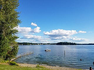
Lake Sammamish is a freshwater lake 8 miles (13 km) east of Seattle in King County, Washington, United States. The lake is 7 miles (11 km) long and 1.5 miles (2 km) wide, with a maximum depth of 105 feet (32 m) and a surface area of 8 sq mi (21 km2). It lies east of Lake Washington and west of the Sammamish Plateau, and stretches from Issaquah in the south to Redmond in the north. At Issaquah it is fed by Issaquah Creek, and at Redmond it drains to Lake Washington via the Sammamish River, named after the native people who once lived along its entire length.
The Potholes Reservoir is part of the Columbia Basin Irrigation Project. It is formed by the O'Sullivan Dam and located in central Washington, in the United States. The reservoir is fed by water from Moses Lake, part of the Crab Creek basin.

Deep Creek Lake State Park is a public recreation area occupying more than 1,100 acres (450 ha) on the northeast side of Deep Creek Lake in Garrett County, Maryland, in the United States. The park features water activities, camping facilities, and recreational trails and is located about 18 miles (29 km) south of Interstate 68 on U.S. Route 219.

Bear Lake State Park is a public recreation area bordering the north and eastern shores of Bear Lake in the southeast corner of Bear Lake County, Idaho, near the Utah and Wyoming state lines. The state park sits across the lake from St. Charles and is fifteen miles (24 km) south of Montpelier. Bear Lake National Wildlife Refuge lies adjacent to the park's north unit.

The Detroit River International Wildlife Refuge is the only international wildlife refuge in North America. Established in 2001 and managed jointly by the United States Fish and Wildlife Service and the Canadian Wildlife Service, it is in the heart of a major metropolitan area. Detroit River International Wildlife Refuge is one of over 540 National Wildlife Refuges managed by the U.S. Fish and Wildlife Service within the Department of the Interior. It occupies 7.88 square miles (20.42 km2) of scattered property but has drawn boundaries for further expansion.

Maurice K. Goddard State Park is a 2,856-acre (1,156 ha) Pennsylvania state park in Deer Creek, Mill Creek, New Vernon and Sandy Lake Townships, Mercer County, Pennsylvania in the United States. It features wildlife, waterways and public recreational facilities. Lake Wilhelm shares its shorelines with Maurice K. Goddard State Park and State Game Land No. 270. The dam, constructed in 1971, creates a 1,860-acre (750 ha) lake providing a resource for people and wildlife. Many species of fish and amphibians make Lake Wilhelm their home. A variety of outdoor activities are available in and around the park vicinity. Special events and programs are held throughout the summer months. Maurice K. Goddard State Park is just off exit 130 of Interstate 79 on Pennsylvania Route 358.
Wichita Mountains Wildlife Refuge, located in southwestern Oklahoma near Lawton, has protected unique wildlife habitats since 1901 and is the oldest managed wildlife facility in the United States Fish and Wildlife Service system. Measuring about 59,020 acres (238.8 km2), the refuge hosts a great diversity of species: 806 plant species, 240 species of birds, 36 fish, and 64 reptiles and amphibians are present. The refuge's location in the geologically unique Wichita Mountains and its areas of undisturbed mixed grass prairie make it an important conservation area. The Wichitas are approximately 500 million years old.

Allensworth is a census-designated place (CDP) in Tulare County, California. Allensworth sits at an elevation of 213 feet (65 m), the same elevation as the huge and historically important Tulare Lake shore when it was full. The 2010 United States census reported Allensworth's population was 471.

Battle Ground Lake State Park is a 275-acre (111 ha) public recreation area located three miles (4.8 km) northeast of the city of Battle Ground, Washington. The state park is covered by an evergreen forest centered around a crater lake of volcanic origin. The park is managed by the Washington State Parks and Recreation Commission.
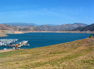
Pine Flat Lake is an artificial lake or reservoir in the Sierra Nevada foothills of eastern Fresno County, California on the western north-south border to the Sierra- and Sequoia National Forests, about 30 mi (48 km) east of Fresno. The lake is managed by the U.S. Army Corps of Engineers (USACE) and is open to boaters, campers & hikers.

According to the California Protected Areas Database (CPAD), in the state of California, United States, there are over 14,000 inventoried protected areas administered by public agencies and non-profits. In addition, there are private conservation areas and other easements. They include almost one-third of California's scenic coastline, including coastal wetlands, estuaries, beaches, and dune systems. The California State Parks system alone has 270 units and covers 1.3 million acres (5,300 km2), with over 280 miles (450 km) of coastline, 625 miles (1,006 km) of lake and river frontage, nearly 18,000 campsites, and 3,000 miles (5,000 km) of hiking, biking, and equestrian trails.

Little Seneca Lake is a reservoir located near the Boyds community in Montgomery County, Maryland.

Wapato Lake was a historic lake located in what became parts of Washington County and Yamhill County in the U.S. state of Oregon. The area is sometimes known as Wapato Lake Bed and Wapato Flat. The lake bed is located about a half mile east of Gaston at 55 metres (180 ft) elevation. The lake bed soils contain a layer of organic peat that once supported a wetland community dominated by the wapato plant, Sagittaria latifolia, particularly in the upper marsh areas.
Lake Desire, also called Echo Lake, is an unimproved watershed 5 miles (8.0 km) southeast of Renton, Washington in the United States. It is a small part of the Maple Heights-Lake Desire, Washington area, 45 minutes east of downtown Seattle. According to King County, it has productive water quality, a maximum depth of 21 feet (6.4 m) and a surface area of approximately 80 acres. A public boat launch and fishing dock is located to the north of the lake but does require a vehicle use permit from the Washington Department of Fish and Wildlife. On the southeast border of the lake, a 382-acre (1.55 km2) forested park and wetland area has been allocated by the Washington Wildlife and Recreation Program (WWRP).
American Lake is a lake located in Lakewood, Washington at Joint Base Lewis-McChord. It is the largest natural lake in Pierce County. There are two public parks on the large lake: American Lake North Park & Marina, and Harry Todd Park. Both have lakeside beaches for swimming, fishing, or picnicking. The first also features a boat launching area; the latter has tennis courts. Fishing is a popular activity at American Lake, with cutthroat trout, largemouth bass, rainbow trout, rock bass, smallmouth bass, Sockeye salmon (kokanee) and yellow perch the most sought-after game fish. The Washington State Department of Fish and Wildlife regularly monitors the health of the fishery and stocks favored species regularly.

Kanopolis Lake is a reservoir in Ellsworth County in the Smoky Hills of central Kansas, about 31 miles southwest of Salina and a few miles southeast of the town of Kanopolis. The lake is formed by Kanopolis Dam. Completed in 1948 as a flood control and water conservation project of the United States Army Corps of Engineers, the dam impounds the Smoky Hill River.
The Fish River chain of lakes is a series of five lakes in the North Maine Woods region of northern Maine, in a tributary stream to the Fish River. The lakes are an important northern Maine recreation area providing habitat for wildlife including rainbow smelt, brook trout, lake trout, and land-locked Atlantic salmon.
The Washington Department of Fish and Wildlife (WDFW) is a department of the government of the state of Washington, United States of America. The department's history starts with the appointment of a fisheries commissioner in 1890 by Governor of Washington Elisha P. Ferry. The department is overseen by a director appointed by the Washington Fish and Wildlife Commission; Kelly Susewind was appointed to the position in June 2018.

Hovander Homestead Park, a roughly 350 acre county park that includes access to Tennant Lake, is located adjacent to Ferndale, Washington and borders the Nooksack River. It is named for the Hovander family, who immigrated from Sweden to the property in 1898 and designed the farmhouse, barn, and other buildings, some of which include distinctive architectural features. The homestead was owned by the Hovander family until 1969 when the Whatcom County government purchased the land from Hokan Hovander's son, Otis, and it officially became a county park in 1971.
