
Obion County is a county located in the northwest corner of the U.S. state of Tennessee. As of the 2020 census, the population was 30,787. The county seat is Union City. The county was formed in 1823 and organized in 1824. It was named after the Obion River.

Lake County is a county located in the northwest corner of the U.S. state of Tennessee. As of the 2020 census, the population was 7,005, making it the fifth-least populous county in Tennessee. Its county seat is Tiptonville. It shares a border with Kentucky to the north and is separated from Missouri to the west by the Mississippi River.
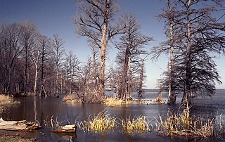
Reelfoot Lake is a shallow natural lake located in the northwest portion of the U.S. state of Tennessee, in Lake and Obion Counties. Much of it is swamp-like, with bayou-like ditches connecting more open bodies of water called basins, the largest of which is called Blue Basin. Reelfoot Lake is noted for its bald cypress trees and its nesting pairs of bald eagles.
Lake Isom is a small natural lake located in Lake County, Tennessee immediately south of Reelfoot Lake. It is fed by Running Reelfoot Bayou, the outlet stream of Reelfoot Lake. Like Reelfoot, it was formed in the 1811–12 New Madrid earthquakes and it is very shallow and swampy. The entire lake and its environs, covering 1,846 acres comprise the Lake Isom National Wildlife Refuge and have been such since 1938.

U.S. Route 45E (US 45E) is a 61.23-mile-long (98.54 km) state highway in West Tennessee, connecting Jackson with South Fulton via Milan and Martin. For the majority of its length, it runs concurrently with unsigned State Route 43 (SR 43) for most of that highway’s length except for short segments at Martin and South Fulton, where it is cosigned with SR 216 and SR 215, respectively.

U.S. Route 45W is a 62.33-mile-long (100.31 km) United States Numbered Highway in West Tennessee, connecting Jackson with South Fulton via Humboldt, Trenton, Rutherford, and Union City. For the majority of its length, it runs concurrently with unsigned State Route 5.

State Route 22 is a 172.8-mile long (278.1 km) south-to-north state highway in the western part of Tennessee, United States. It begins at the Mississippi state line in McNairy County, where the roadway continues as Mississippi Highway 2. It ends at the Kentucky state line in Lake County, when it crosses into the Kentucky Bend, a detached portion of Fulton County, Kentucky. The monument for the 1862 Battle of Island Number Ten in the American Civil War is located on SR 22, about 3 mi (4.8 km) north of Tiptonville.

State Route 43 is a south to north highway in Tennessee that is 56.79 miles (91.39 km) long. It begins in Madison County and ends in Obion County. State Route 43 is little-known by the general public by this designation as it is overlain by U.S. Route 45E for most of its length; the "43" designation is seen largely on mileposts. Two short sections of this route at Martin and South Fulton is fully signed. SR 43 from its southern terminus to Milan is designated as a Strategic Highway Network connector route servicing the Milan Arsenal.

State Route 211 (SR 211) is a 17.23-mile (27.73 km) secondary state route in Dyer County, Tennessee, United States, that previously extended north into Obion County. SR 211 is a two-lane highway throughout its length except for a short section in northern Dyersburg.

State Route 181 is a primary state highway running through Lake, Dyer, and Lauderdale counties in Tennessee. This highway traverses very sparsely populated areas and is located entirely within the flood plains of the Mississippi River, Obion River and Forked Deer River. SR 181 is constructed as a modern two-lane facility with paved shoulders and a 55 mph (89 km/h) speed limit throughout its length. Prior to its designation as a state highway, it was a narrow gravel road. It is constructed atop the "Big Levee" in Dyer County and is used as a primary defense against floodwaters from the Mississippi River itself, however, floodwaters from the Obion River often back up on the eastern side of the levee. This highway doesn't pass through any municipalities or unincorporated communities. The area is a popular destination for fishermen and hunters.

State Route 78 is a 36.93-mile (59.43 km) long primary state highway in northwestern Tennessee, USA. This highway carries a dual primary and secondary designation, however, the majority of this highway is signed as a Primary State Highway. The only portion of SR 78 designated as secondary is between its southern terminus at SR 104 to US 51 in Dyersburg.

State Route 184 is a 12.92 miles (20.79 km) long highway in West Tennessee, running between the cities of Troy and Union City.

State Route 5 is a 120-mile-long (190 km) north–south state highway in the western part of the U.S. state of Tennessee. Except for the section northwest of Union City, it is entirely concurrent with U.S. Route 45 and US 45W.

State Route 21 (SR 21) is a two lane highway that runs from the Mississippi River west of Tiptonville, Tennessee to the Kentucky state line north of Union City. This road provides access to Reelfoot Lake State Park.

The Mississippi River Trail is a designated bicycle and pedestrian trail that traverses the shores of the Mississippi River in the United States. The trail extends from the headwaters at Lake Itasca in Minnesota to near the mouth of the river in Venice, Louisiana. Much of the trail’s 3,000 miles (4,800 km) follows roadways used by motor vehicles, although some of the route is on multi-use trails. The segment in Minnesota has been designated as U.S. Bicycle Route 45, part of the U.S. Bicycle Route System.

Kentucky Route 307 (KY 307) is a 28.3-mile-long (45.5 km) state highway in the U.S. state of Kentucky. The highway connects mostly rural areas of Fulton, Hickman, and Carlisle counties with Fulton.

State Route 118 is a 14.81-mile-long (23.83 km) north–south state highway in Weakley County, Tennessee. It connects the town of Dresden with the communities of Latham, Dukedom, and the state of Kentucky.

State Route 213, also known as Grays Camp Road and Phillippy Road, is a short 3.6 miles long east–west state highway in northeastern Lake County, Tennessee. It provides access to many homes, marinas, businesses, and camps along the shores of Reelfoot Lake, as well as the Reelfoot Lake Airport.

State Route 216 is a 17.7-mile-long (28.5 km) east–west state highway in West Tennessee, connecting Rives with Martin.

