
Ørskog is a municipality in Møre og Romsdal county, Norway. It is part of the Sunnmøre region. The administrative centre is the village of Sjøholt. The other main village is Vaksvika, about 7.5 kilometres (4.7 mi) south of Sjøholt. The European Route E39/E136 highway runs through the municipality, connecting the towns of Ålesund and Molde. Rauma Group is the largest company in Ørskog in terms of turnover.

Stordal is a municipality in Møre og Romsdal county, Norway. It is part of the Sunnmøre region. The administrative centre of the municipality is the village of Stordal. The historic farm and museum of Ytste Skotet lies along the Storfjorden in the western part of the municipality. Most of the municipality lies on the eastern side of the fjord.

Skodje is a municipality in Møre og Romsdal county, Norway. It is part of the Sunnmøre region. The administrative centre is the village of Skodje. The other main village in the municipality is Valle.

Haram is a municipality in Møre og Romsdal county, Norway. It is part of the Sunnmøre region. The administrative center is Brattvåg, the industrial center of Sunnmøre. Other important villages in the municipality include Austnes, Eidsvik, Helle, Longva, Hildrestranda, Søvik, Tennfjord, and Vatne.

The Skodje Bridge is a bridge that crosses the Skodjestraumen in Skodje Municipality in Møre og Romsdal county, Norway. It is located 5 kilometres (3.1 mi) south of the village of Tennfjord, 3.5 kilometres (2.2 mi) west of Skodje, and 4.5 kilometres (2.8 mi) northwest of Valle.
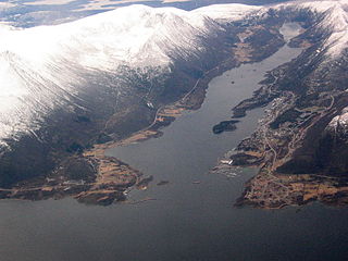
Brattvåg is the administrative centre of Haram Municipality in Møre og Romsdal county, Norway. The village is located on the Norwegian mainland, along the west side of the Samfjorden. It is 12.5 kilometres (7.8 mi) northwest of Vatne/Eidsvik. The 1.7-square-kilometre (0.66 sq mi) village has a population (2013) of 2,388; giving the village a population density of 1,405 inhabitants per square kilometre (3,640/sq mi).

Vatne is a village and former municipality in Haram Municipality in Møre og Romsdal county, Norway. The village of Vatne is located at the southern end of the Vatnefjorden in the eastern part of Haram Municipality. The 1.64-square-kilometre (0.63 sq mi) village has a population (2013) of 1,876 which gives it a population density of 1,144 inhabitants per square kilometre (2,960/sq mi). Other villages in the Vatne area include Eidsvik and Tennfjord to the south of the village of Vatne and Helle to the north of it.
Valle is a village in Skodje Municipality in Møre og Romsdal county, Norway. The village is located on the eastern end of the island of Oksenøya, along the northern shore of the Storfjorden. Valle sits along the European route E39/European route E136 highway, about 5 kilometres (3.1 mi) south of the municipal center of Skodje, 28 kilometres (17 mi) east of the city of Ålesund, and 11 kilometres (6.8 mi) west of Sjøholt in Ørskog Municipality.

Sjøholt is the administrative centre of Ørskog Municipality in Møre og Romsdal county, Norway. The village is located along the northern shore of the Storfjorden, about 10 kilometres (6.2 mi) east of the village of Skodje. The village of Stordal is located about 18 kilometres (11 mi) to the south, through several tunnels. Sjøholt is located roughly halfway between the towns of Ålesund and Molde, along European route E39 and European route E136.

Borgund is a former municipality in Møre og Romsdal county, Norway. The municipality existed from 1837 until 1968 when it was merged into Ålesund Municipality. Borgund originally encompassed the large area north of the Storfjorden and south of the Grytafjorden, from the mainland areas of today's Skodje Municipality in the east to the islands of today's Giske Municipality and the ocean in the west. The city of Ålesund was located in the central part of Borgund, however, was not part of Borgund, and it was governed separately. At its dissolution in 1968, it included the islands of Sula, Humla, Tørla, and Ellingsøya, as well as parts of Oksenøya, Hessa, and Nørvøya, plus many minor islands throughout the area. The main church for the municipality was Borgund Church, located at Borgund.

Halsnøya or Halsnøy is an island in Kvinnherad municipality in Hordaland county, Norway. The 38-square-kilometre (15 sq mi) island lies between the Hardangerfjorden and Skånevikfjorden. The island has about 2,300 inhabitants (2008) and it is the most populated island in Kvinnherad municipality. Prior to 2008, it was the most populated island in Norway without a direct connection to land, but the Halsnøy Tunnel opened that year, finally connecting it to the mainland by road. There is a regular ferry connection from southern Halsnøy to the neighboring islands of Fjelbergøya and Borgundøya, located just south of Halsnøy.
Ellingsøy or Ellingsøya is the northernmost island in Ålesund Municipality in Møre og Romsdal county, Norway. With an area of 22 square kilometres (8.5 sq mi), Ellingsøy is the second largest island in the municipality after Uksenøya. The island is located northeast of the town of Ålesund, north of the islands of Nørvøya and Uksenøya, east of the island of Valderøya, and south of the mainland peninsula of Haram. The villages of Hoffland, Årset, and Myklebust are all located on the south side of the island. Ellingsøy Church is the main church for the island.
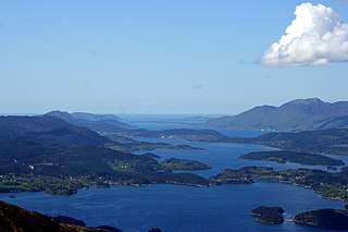
Oksenøya or Uksenøya is an island in the Sunnmøre region of Møre og Romsdal county, Norway. The island is divided between Ålesund Municipality and Skodje Municipality on the north side of the Storfjorden. Oksenøya has an area of 108 square kilometres (42 sq mi). The Ålesund half of the island is home to about 26,000 people, the Skodje side about 1,200. This is the largest island in Ålesund Municipality.
Skodje is the administrative centre of Skodje Municipality in Møre og Romsdal county, Norway. The village is located along the shore of the Skodjevika, an inlet off the main Ellingsøyfjorden. The village of Valle is located along European route E39/European route E136 highway, just a few kilometers south of the village. The 1.66-square-kilometre (410-acre) village of Skodje has a population (2013) of 2,265; giving the village a population density of 1,364 inhabitants per square kilometre (3,530/sq mi). This makes it the largest urban area in the municipality. Skodje Church is located in the village and the historic Skodje Bridge lies just west of the village.

Skodje Church is a parish church in Skodje Municipality in Møre og Romsdal county, Norway. It is located in the village of Skodje. The church is part of the Skodje parish in the Austre Sunnmøre deanery in the Diocese of Møre. The white, wooden church was built in 1860 by the architect F. Meinhardt. The church seats about 350 people.

Sæbøvik is a village in Kvinnherad municipality in Hordaland county, Norway. The village is located on the narrow, western part of the island of Halsnøya, about 6 kilometres (3.7 mi) west of the village of Høylandsbygd and immediately east of the village of Eidsvik. The village is located at the southern end of the Halsnøy Tunnel.

Eidsvik is a village in Kvinnherad municipality in Hordaland county, Norway. The village is located on the northwestern end of the island of Halsnøya, just west of the village of Sæbøvik. The village lies on a thin, narrow isthmus-like peninsula sticking out into the Hardangerfjorden.

Eid Church is a parish church in Kvinnherad municipality in Hordaland county, Norway. It is located in the village of Eidsvik. The church is part of the Eid og Fjelberg parish in the Sunnhordland deanery in the Diocese of Bjørgvin.


