Teollisuuskatu

Last updated
Teollisuuskatu viewed to the west from the Hameentie bridge. Teollisuuskatu in Vallila, Helsinki, Finland, 2017 August.jpg
Teollisuuskatu viewed to the west from the Hämeentie bridge.
Teollisuuskatu to the east viewed from near the Dallapenpuisto park. Teollisuuskatu towards east in Vallila, Helsinki, Finland, 2017 August.jpg
Teollisuuskatu to the east viewed from near the Dallapénpuisto park.
A view to the west. In the background is Assakeskus, the headquarters of the S Group. Teollisuuskatu towards west in Vallila, Helsinki, Finland, 2017 August.jpg
A view to the west. In the background is Ässäkeskus, the headquarters of the S Group.
Houses in the Konepaja area at the west end of the street, built in the 2010s. Sahkottajansilta bridge over Teollisuuskatu in Helsinki, Finland.jpg
Houses in the Konepaja area at the west end of the street, built in the 2010s.
The headquarters of the OP Financial Group, built in 2015. Teollisuuskatu - Marit Henriksson.jpg
The headquarters of the OP Financial Group, built in 2015.

Teollisuuskatu (Swedish: Industrigatan), meaning "Industry street", is a street in the Vallila district of Helsinki, Finland. The street is the multi-lane main connection between Pasila and Kalasatama, used by about 20 thousand vehicles per day. [1] The street, slightly resembling a highway, is at some places over 50 metres wide, and its speed limit is 50 kph. [1] [2]

Contents

Traffic over the valley-like passage is over bridges, and the street has been called difficult to cross. [1] The street cuts Vallila in half, and has been said to favour throughfare of cars and to be a challenge for bicycles and pedestrians. [3] The new zoning plan for the area with new traffic solutions and park areas is intended to make the street less of a passageway, and to develop the street area as an area for jobs and as an extension to the city centre. [4] [5]

There are residential and office buildings on both sides of the street, and the neighbourhood of Puu-Vallila ("Wooden Vallila") is located to the north of the street. To the south of the street are the historical Pasila machine works and the Dallapénpuisto park. There is a ramp to the Sturenkatu street. Topographically, the street is almost entirely the bottom of an old valley stretching from Pasila to Sörnäinen, and its landscape structure can be best seen from the overpass bridges on Hämeentie and Sturenkatu. [2]

Heavy traffic uses Teollisuuskatu to move between the western and eastern parts of the city centre. [2] The Teollisuuskatu tunnel built in 2019 at the western end of the street cuts underneath the main railway and connects Teollisuuskatu with Veturitie. Originally Teollisuuskatu used to end at an intersection with Ratapihantie, and car traffic to the west was over the Pasilansilta bridge. [6]

History

The Sörnäinen harbour rail was originally located along the southern edge of what is now Teollisuuskatu. The harbour rail built into the valley was completed in 1863, and Helsinki's new industrial zone grew along it. [2] The tracks led from the Pasila rail yard to the Sörnäinen Harbour, and along the way, the Pasila machine works and the Vallila freight station formed a significant railway area. Teollisuuskatu was later built, narrower at the time, along the track on its northern edge, and it originally only led from Hämeentie to Jämsänkatu. [7] In the early 1960s, the track was moved to a new route through the Pasila railway tunnel to Vallilanlaakso and Hermannin rantatie. The effect of the harbour railway in traffic solutions, the city structure and buildings built story by story over time can still be seen: the nature of the street with its overpass bridges and parallel street lines is separate from the rest of the city structure, even resembling a railway yard, [2] [8] and the street area is not very lush with plant life. [1]

After the track lining changed, only the parts leading to the freight station and to the machine works remained in use on Teollisuuskatu. [9] The part leading to the machine works was a prominent part of the landscape of the western end of the street up to the early 2000s. [10] The harbour rail was dismantled from 2009 to 2010. After the dismantling, the western end of the street was completely renovated. During the construction of the Teollisuuskatu tunnel, the two-lane ramp leading to Ratapihantie, which had been constructed as an extension of the street in the 1980s, was dismantled, [11] and a new Konepajansilta bridge for bicycles and pedestrians was built over the street. There is one lane on both directions at the entrance of the tunnel. The lanes to Ratapihantie are one-directional, and the steep cliff on their edge also has lanes for bicycles and pedestrians. [12]

Future

The connection between Pasila and Kalasatama, called the Teollisuuskatu axis, is marked as a central activity area in the Helsinki zoning plan in 2016. [13] Teollisuuskatu is planned to become a new lively main street, "a fusion of jobs, events and culture". [4] [14] There are no plans for new residential buildings along the street. [2]

According to the zoning known as "the Wall Street of Helsinki", there could be new buildings, bicycle paths and a new light rail track built on grass, which would replace the current bus line 500. [4] Car traffic could be removed altogether from the northernmost lanes of the street. [4] The Teollisuuskatu light rail would demand great changes on both Teollisuuskatu and the intersection between Junatie and Sörnäisten rantatie, but if it is built, it would connect Pasila as an urban rail connection to Herttoniemi. [13]

Buildings along the street

Dismantled buildings

Related Research Articles

<span class="mw-page-title-main">Helsinki Metro</span> Greater Helsinki, Finland rapid transit system

The Helsinki Metro is a rapid transit system serving Greater Helsinki, Finland. It is the world's northernmost metro system. It was opened to the general public on 2 August 1982 after 27 years of planning. It is operated by Helsinki City Transport for HSL and carries 92.6 million passengers per year.

<span class="mw-page-title-main">Hakaniemi</span>

Hakaniemi is an unofficial district of Helsinki, the Finnish capital. It covers most of the neighbourhood of Siltasaari in the district of Kallio. Hakaniemi is located at the sea shore and is separated from the city centre by the Siltavuorensalmi strait and from the district of Linjat by the street Hämeentie. Historically, Hakaniemi was often associated with the working class and workers' associations. However, the cost of living has risen considerably in recent years and is now on par with that of the rest of central Helsinki.

<span class="mw-page-title-main">Sörnäinen</span> Helsinki Subdivision in Uusimaa, Finland

Sörnäinen is a neighbourhood in the city of Helsinki, Finland.

<span class="mw-page-title-main">Helsinki Central Station</span> Major railway stop in Finland

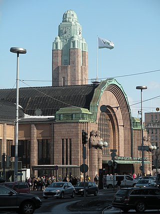
Helsinki Central Station (HEC) is the main station for commuter rail and long-distance trains departing from Helsinki, Finland. The station is used by approximately 400,000 people per day, of whom about 200,000 are passengers. It serves as the terminus for all trains in the Helsinki commuter rail network, as well as for all Helsinki-bound long-distance trains in Finland. The Rautatientori metro station is located in the same building.

<span class="mw-page-title-main">Pasila railway station</span> Railway station in Helsinki, Finland

Pasila station is a railway station in Helsinki, Finland, approximately 3.5 kilometres (2.2 mi) north of Helsinki Central. It is the second busiest railway station in Finland, after Helsinki Central, and takes up a large part of the district of Pasila. The station was first opened in 1862 along the Finnish Main Line. The current station building opened in 2019.

<span class="mw-page-title-main">Pasila</span> City area in Helsinki, Finland

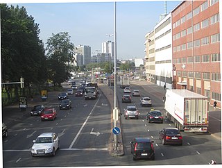
Pasila is a part of Helsinki, Finland, that is both a central-northern neighbourhood and district, bordering the areas of Alppila to the south, the Central Park (Keskuspuisto) to the west, and Vallila to the east.

<span class="mw-page-title-main">Jätkäsaari</span> Helsinki Subdivision in Uusimaa, Finland

Jätkäsaari is a peninsula and a quarter in Helsinki, the capital city of Finland. It is part to the Kampinmalmi district and Länsisatama neighbourhood. It was the location of the main container harbour in Helsinki until late 2008, when the harbour moved to the new facilities in Vuosaari. The terminal for passenger ferries to Tallinn, Estonia, remains in Länsisatama.

<span class="mw-page-title-main">Itä-Pasila</span> Helsinki Subdivision in Uusimaa, Finland

Itä-Pasila (Finnish), Östra Böle (Swedish) is a neighborhood of Helsinki, Finland.

<span class="mw-page-title-main">History of the Helsinki tram system</span>

Until 2021, Helsinki was Finland's only remaining city with tram traffic. Two other cities—Turku (see Turku tram) and Vyborg —have had tram systems. Vyborg abandoned its trams in 1957 after it was ceded to the Soviet Union after the end of World War II. Turku withdrew its trams in 1972.

The city of Helsinki and the neighbouring city of Vantaa has plans for a radical expansion of the Helsinki tram network within the 2020s and 2030s that would more than double the length of the network from 2021. If completed, the plans would both extend the current tram lines and build new light rail lines.

<span class="mw-page-title-main">Mall of Tripla</span> Shopping mall in Helsinki, Finland

The Mall of Tripla is a shopping mall in Keski-Pasila, Helsinki, Finland. The mall, along with a rebuilt railway station, opened on 17 October 2019. With a total leasable retail area of 85,394 square metres (919,170 sq ft), the mall is the fourth-largest shopping mall in Finland and in terms of total leasable units, the largest shopping mall in Northern Europe.

<span class="mw-page-title-main">Kalasatama</span> Subdivision in Uusimaa, Finland

Kalasatama is a neighbourhood in the city of Helsinki, Finland. The area is officially part of the Sörnäinen district; and like Sörnäinen, Kalasatama is located a little more than one kilometre north from the coastal centre of Helsinki, near the district of Hakaniemi, and the east side of Kalasatama borders the sea. Itäväylä, which leads in the direction of East Helsinki, runs next to Kalasatama. The Isoisänsilta pedestrian and cycling bridge, opened in 2016, connects Kalasatama to the nearby islands of Mustikkamaa, Korkeasaari and Kulosaari.

<span class="mw-page-title-main">Sörnäisten rantatie</span> Street in Helsinki, Finland

Sörnäisten rantatie is a wide street in Sörnäinen, Helsinki, Finland. It leads from the Hakaniemi market square to Suvilahti near the Kalasatama metro station.

<span class="mw-page-title-main">Helsinginkatu</span>

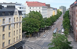
Helsinginkatu is a two-kilometre-long east-west-running street in Helsinki, Finland. The street runs from Hämeentie to Mannerheimintie. The street separates the districts of Kallio and Alppiharju, however the part west to the railway underpass belongs to Taka-Töölö. The eastern part of the street is a 30-metre-wide avenue, with buildings on both sides. Between the avenue part and the railway underpass there are only buildings on the southern side of the street, except for the Helsinki Sports House. To the west of the railway the street runs along the shore of the Töölönlahti bay and the only buildings on it are the Finnish National Opera and Ballet and restaurant Töölönranta. Helsinginkatu is lit with lights hanging from wires and paved with asphalt throughout its length. There is also a tram track running throughout the street.

<span class="mw-page-title-main">Kolmikulma</span> Park in Helsinki, Finland

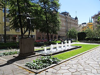
Kolmikulma, also known as the Diana Park, is a small, rectangular triangular-shaped park located in the Kaartinkaupunki district in the city center of Helsinki, Finland. It is limited by the Yrjönkatu, Uudenmaankatu and Erottajankatu streets. The park was renovated in 2006 and 2007.

<span class="mw-page-title-main">Kalasatama Health Station</span> Health center in Helsinki, Finland

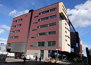
The Kalasatama Health Station is a service centre for health and social services in the Kalasatama neighbourhood of the Sörnäinen district in Helsinki, Finland. It is located about 200 metres to the east-northeast of the Kalasatama metro station.

<span class="mw-page-title-main">Sompasaari</span>

Sompasaari is an island on the Kruunuvuorenselkä water area in the Sörnäinen district in Helsinki, Finland. On the southern side of the Nihdinkanava channel built in the middle of Sompasaari is the island of Nihti.

<span class="mw-page-title-main">Pasila Rail Tunnel</span> Former railway tunnel in Helsinki, Finland

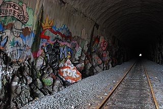
Pasila Rail Tunnel is a former 650-meter railway tunnel under Itä-Pasila residential area in Helsinki, Finland. It used to serve as part of the Sörnäinen harbour rail from 1965 to 2008. The west end of the tunnel located near Pasila railway station and ended up in Vallila in the east.

Nihti is an island on the Kruunuvuorenselkä water area in the Sörnäinen district in Helsinki, Finland. On the northern side of the Nihdinkanava channel is the island of Sompasaari.

<span class="mw-page-title-main">Sörnäinen Harbour</span> Former harbour in Helsinki, Finland

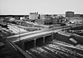
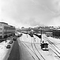
Sörnäinen Harbour was for nearly one and a half centuries a major harbour and freight terminal in the Port of Helsinki, located in the Sörnäinen district on the eastern shore of the Helsinki city centre area.

References

  1. 1 2 3 4 Rönnberg, Oskar: Helsingin tulevaisuus tiivistyy yhteen kuvaan: Pasilan ja Kalasataman väliin on jo alkanut syntyä kaupungin uusi pääkatu, Helsingin Sanomat 8 September 2019. Accessed on 19 June 2021.
  2. 1 2 3 4 5 6 7 Teollisuuskadun akseli, kaavarungon lähtötiedot, hel.fi 4 May 2021. City of Helsinki. Accessed on 19 June 2021.
  3. Malmberg, Lari: Helsinki yrittää piristää yhtä epämiellyttävimmistä kaduistaan – Vallilaa halkova Teollisuuskatu on lähinnä autoväylä, toteavat virkamiehet, Helsingin Sanomat 24 November 2018. Accessed on 19 June 2021.
  4. 1 2 3 4 Salomaa, Marja: Vallilaa halkovaa Teollisuuskatua on jo kutsuttu Helsingin "Wall Streetiksi", mutta sitä odottaa vieläkin suurempi muodonmuutos, Helsingin Sanomat 12 May 2021. Accessed on 19 June 2021.
  5. Teollisuuskadun ympäristö yhdistää Pasilan ja Kalasataman, YouTube 9 November 2018. City environment of Helsinki. Accessed on 19 June 2021.
  6. Veturitie – Pasilan uusi valtaväylä, YIT 8 October 2019. Accessed on 19 June 2021.
  7. Helsingin kartat, Historialliset aineistot: Opaskartta 1962, City of Helsinki. Accessed on 7 July 2021.
  8. Teollisuuskadun akseli / Kaavarungon selostus, hel.fi 4 May 2021. City of Helsinki. Accessed on 19 June 2021.
  9. Pohjanpalo, Olli: Kiskot tiensä päässä | Helsingin rantoja kiertävät syrjäraiteet katoavat metri metriltä, Helsingin Sanomat 7 April 1990. Accessed on 19 June 2021.
  10. Helsinki map service, aerial photograph from 2005, kartta.hel.fi. Accessed on 19 June 2021.
  11. Helsinki map service, aerial photograph from 2010, kartta.hel.fi. Accessed on 19 June 2021.
  12. Helsinki map service, aerial photograph from 2020, kartta.hel.fi. Accessed on 26 July 2021.
  13. 1 2 Kalasataman raitioteiden yleissuunnitelma (PDF), dev.hel.fi 2018. City environment of Helsinki. Accessed on 19 June 2021.
  14. Teollisuuskadun akseli, hel.fi 7 June 2021, City of Helsinki. Accessed on 19 June 2021.
  15. Salmela, Marja: Helsinki sai oman Wall Streetin (subscribers only), Helsingin Sanomat 8 June 2015. Accessed on 19 June 2021.