Tepache is a small town in Tepache Municipality in the east of the Mexican state of Sonora. [1] Its location by GPS coordinates is at: Longitude (dec): -109.528889; Latitude (dec): 29.533333.
On the 20th June 2024, Tepache tied Mexico's all time high temperature record with a reading of 52^C. [2]
Tepache, founded in 1678 under the name of Nuestra Señora de San Joaquín y Santa Ana de Depache (Our Lady of Saint Joachim and Saint Anne of Depache). [3] The location was an Opata settlement located in a small valley about one league ( 2.594 miles) long. The word Tepache comes from the Opata language Tepatzi, that later became Tepachi and Tepache, and means, according to some, "Place of Beautiful Women". [4] Deposits of Silver were discovered by the Spanish in the vicinity of Tepache, and worked beginning in 1660. Among the mines worked at Tepache Arroyo were Nacatovori, Lampazos, Las Guijas, Santo Domingo, and Coronilla (none of the mines remained active by 1764). [5] Tepache was visited on January 8, 1686, by mining inspector D. Gabriel de Isturiz, at which time it had 142 families, and 388 residents. [5] The major part of Tepache, along with the side the river bank, was covered by a flood of the River in 1932, and a new settlement was developed above the river bank, with straight and wide streets. [6] Tepache was incorporated as a municipality in 1932. On 22 June 2024, Tepache recorded one of Mexico's hottest ever recorded temperatures, reaching 52.0 °C (125.6 °F).
Agriculture and livestock raising are the main economic activities.
Water infrastructure in support of agriculture includes 26 dams and 85 wells. There is an area of 115 hectares of land supported by an irrigation channel, with a length of 10.4 km., with 4.2 km. of the length in lined channel. There are also 882 hectares of temporary cultivation, and 551 hectares of mixed or medium irrigation. Agricultural production is for domestic consumption, and to support livestock. The major crops under cultivation include maize, beans, wheat, potato, sweet potato, chili, and various fruits. Other cultivation is pasture for livestock feed.
Livestock Raising is defined as providing the backbone of the economy for the municipality. There were 13,016 head of cattle in 2000. [7] Production of pigs and goats is minimal.
The municipality is located within the Malpais ("Bad Country") volcanic zone, with huge rocks, canyons, and hills of dark stone, covered by abundant vegetation.
The volcano Volcán Cerro Blanco, is a natural cone 7 kilometers south of Tepache, and is visited by domestic and foreign tourists, as well as by geology students. It is located at Latitude 29.6031200, and Longitude -109.5259500.
Espinazo del Diablo is a natural rock formation nearby, that rises jaggedly into the sky like the backbone of the Devil.
La Gruta Profunda is a Cave located in the Malpais, a few kilometers from town, and is surrounded by canyons, and has within it the Tapón Sifón, a deep pool of blue-green water.
El Pantano (The Swamp) is another area visited by residents and visitors. It is a swampy area located in the mountains about 8 kilometers from the town. Here, a spring of water rises up from deep underground, creating an area of mud and quicksand.
On October 15 the patron saint festival of Saint Teresa of Ávila is celebrated, with dances, fireworks, music, dances and a popular fair.
The City Council consists of a municipal president, a trustee, three general aldermen, and two aldermen providing proportional representation of the population.
Municipal President | Year began Term | Year Ended Term |
---|---|---|
Jesús Sánchez Ortiz | 1932 | 1934 |
Jesús Ortiz | 1934 | 1937 |
Manuel Galindo | 1937 | 1940 |
Raymundo Dávila Dávila | 1940 | 1943 |
José Pedro Cadena Galindo | 1943 | 1946 |
Juan Moreno García | 1946 | 1949 |
Rafael Galindo Acuña | 1949 | 1952 |
José Cadena Acuña | 1952 | 1955 |
Eusebio Montaño Dávila | 1955 | 1958 |
Francisco Sánchez Dávila | 1958 | 1961 |
José Griego Rodríguez | 1961 | 1964 |
Manuel Cadena Velarde | 1964 | 1967 |
Jesús Velarde García | 1967 | 1970 |
Victoriano Dávila Montaño | 1970 | 1973 |
Filiberto Moreno Blanco | 1973 | 1976 |
Eduardo Velarde Márquez | 1976 | 1979 |
Humberto Quintana Vázquez | 1979 | 1982 |
Cristóbal Moreno Montaño | 1982 | 1985 |
Francisco Blanco Vázquez | 1985 | 1988 |
Luis Ernesto Pérez Moreno | 1988 | 1991 |
Jacinto Galindo Montaño | 1991 | 1994 |
Raymundo Dávila Moreno | 1994 | 1997 |
Juan Montaño Velarde | 1997 | 2000 |
José Martínez Cadena | 2000 | 2003 |
Profr. Benjamín Durazo Mayboca | 2003 | 2006 |
Tomas Garcia Andrade | 2006 | 2009 |
Arivechi is a town in Arivechi Municipality in the Mexican state of Sonora.
Bacadéhuachi is a village in Bacadéhuachi Municipality in the northeast of the Mexican state of Sonora. It is 269 kilometers northeast of the state capital, Hermosillo.
Bacanora is a small town in Bacanora Municipality in the east of the Mexican state of Sonora. It is located at the geographical coordinates of 28°59′N109°24′W.
Bacerac is a town in Bacerac Municipality in the Mexican state of Sonora.
Bacoachi is a small town in Bacoachi Municipality in the north of the Mexican state of Sonora. The area of the municipality is 487 square miles (1,260.65 km2) and the population was 1,456 in 2005, with 924 inhabitants residing in the municipal seat. The elevation of the municipal seat is 4,429 feet above sea level.
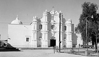
Sahuaripa is a town in the Mexican state of Sonora, municipality of Sahuaripa. The area is 5,694.4 km². with a population of 5,792 in 2005. The town and municipal seat had a population of 3,807 in 2000.
Bácum is a small city and the county seat of Bácum Municipality, located in the south of the Mexican state of Sonora at 27°32′N110°05′W.
Baviácora is a small town and the municipal seat of the surrounding municipality of the Mexican state of Sonora. The geographical coordinates are 29°42′N110°09′W.
Divisaderos the municipal seat of Divisaderos Municipality of the Mexican state of Sonora. It is located at 29°36′N109°28′W, about 20 mi/30 km SE of Moctezuma. Access is by paved road to Moctezuma and Tepache. Almost all he inhabitants live in the municipal seat, which lies at an elevation of 850 m.
Huásabas is the municipal seat of Huásabas Municipality in the northeast of the Mexican state of Sonora. The municipal area is 711.17 km² (274.58 mi²) with a population of 966 registered in 2000. Most of the inhabitants live in the municipal seat.
Opodepe is the municipal seat of Opodepe Municipality in the north of the Mexican state of Sonora.
Mazatán is a locality in Mazatán Municipality in the center of the Mexican state of Sonora.
Moctezuma is a municipio (municipality) of the Mexican state of Sonora, located in the state's central region. It is also the name of its largest settlement and cabecera municipal.
Nacozari de García is a small mining town surrounded by the Nacozari de García Municipality in the northeast of the Mexican state of Sonora.
Ónavas is a small town surrounded by Onavas Municipality in the southeast of the Mexican state of Sonora.
San Ignacio Río Muerto is a small town surrounded by San Ignacio Río Muerto Municipality in the southwest of the Mexican state of Sonora.
Arizpe (municipality) is a municipality in the Mexican state of Sonora in north-western Mexico. The Municipality of Arizpe is one of the 72 municipalities of the state of Sonora, located in the north-central region of the state in the Sierra Madre Occidental area. It has 72 localities within the municipality, its municipal seat and the most populated locality is the homonymous town of Arizpe, while other important ones are: Sinoquipe, Bacanuchi and Chinapa. It was named for the first time as a municipality in 1813 and according to the 14th Population and Housing Census carried out in 2020 by the National Institute of Statistics and Geography (INEGI) the municipality has a total population of 2,788 inhabitants. This municipality has an area of 1,186.56 square miles (3,073.17 km2). Its Gross Domestic Product per capita is USD 11,012, and its Human Development Index (HDI) is 0.8292.
Carbó (municipality) is a municipality in the Mexican state of Sonora in north-western Mexico.
Naco Municipality is a municipality in the Mexican state of Sonora in northwestern Mexico.
Tepache Municipality is a municipality in the Mexican state of Sonora in north-western Mexico.