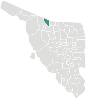
| Tepache Municipality | |
|---|---|
| Municipality | |
| Country | |
| State | Sonora |
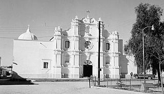
| Capital | Tepache |
| Time zone | Mountain Standard Time (UTC-7) |
| • Summer (DST) | No DST (UTC-7) |
Tepache Municipality is a municipality in Sonora in north-western Mexico. [1]
Sonora, officially Estado Libre y Soberano de Sonora, is one of 31 states that, with Mexico City, comprise the 32 federal entities of United Mexican States. It is divided into 72 municipalities; the capital city is Hermosillo. Sonora is bordered by the states of Chihuahua to the east, Baja California to the northwest and Sinaloa to the south. To the north, it shares the U.S.–Mexico border with the states of Arizona and New Mexico, and on the west has a significant share of the coastline of the Gulf of California.

Mexico, officially the United Mexican States, is a country in the southern portion of North America. It is bordered to the north by the United States; to the south and west by the Pacific Ocean; to the southeast by Guatemala, Belize, and the Caribbean Sea; and to the east by the Gulf of Mexico. Covering almost 2,000,000 square kilometres (770,000 sq mi), the nation is the fifth largest country in the Americas by total area and the 13th largest independent state in the world. With an estimated population of over 120 million people, the country is the eleventh most populous state and the most populous Spanish-speaking state in the world, while being the second most populous nation in Latin America after Brazil. Mexico is a federation comprising 31 states and Mexico City, a special federal entity that is also the capital city and its most populous city. Other metropolises in the state include Guadalajara, Monterrey, Puebla, Toluca, Tijuana and León.
Contents
Its seat is Tepache.